You are here: Home > Network List > XM99 - Rio Grande Seismic Transect Stations List
> Station NM28 NewMexico28 > Earthquake Result Viewer
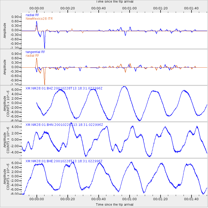
NM28 NewMexico28 - Earthquake Result Viewer
*The percent match for this event was below the threshold and hence no stack was calculated.
| Earthquake location: |
Southeast Of Loyalty Islands |
| Earthquake latitude/longitude: |
-22.0/170.1 |
| Earthquake time(UTC): |
2001/02/28 (059) 13:05:31 GMT |
| Earthquake Depth: |
10 km |
| Earthquake Magnitude: |
5.8 MB, 6.1 MS, 6.2 MW |
| Earthquake Catalog/Contributor: |
WHDF/NEIC |
|
| Network: |
XM Rio Grande Seismic Transect |
| Station: |
NM28 NewMexico28 |
| Lat/Lon: |
34.54 N/106.70 W |
| Elevation: |
1484 m |
|
| Distance: |
96.9 deg |
| Az: |
55.648 deg |
| Baz: |
248.146 deg |
| Ray Param: |
$rayparam |
*The percent match for this event was below the threshold and hence was not used in the summary stack. |
|
| Radial Match: |
95.8843 % |
| Radial Bump: |
400 |
| Transverse Match: |
64.272446 % |
| Transverse Bump: |
400 |
| SOD ConfigId: |
3744 |
| Insert Time: |
2010-02-26 17:31:37.538 +0000 |
| GWidth: |
2.5 |
| Max Bumps: |
400 |
| Tol: |
0.001 |
|
Signal To Noise
| Channel | StoN | STA | LTA |
| XM:NM28:01:BHN:20010228T13:18:31.022996Z | 1.1449912 | 1.8477414E-6 | 1.6137604E-6 |
| XM:NM28:01:BHE:20010228T13:18:31.022996Z | 1.3714163 | 6.359036E-6 | 4.6368386E-6 |
| XM:NM28:01:BHZ:20010228T13:18:31.022996Z | 0.78478104 | 3.1851323E-6 | 4.0586256E-6 |
| Arrivals |
| Ps | |
| PpPs | |
| PsPs/PpSs | |


