You are here: Home > Network List > XM99 - Rio Grande Seismic Transect Stations List
> Station TX01 Texas01 > Earthquake Result Viewer
TX01 Texas01 - Earthquake Result Viewer
| Earthquake location: |
South Of Panama |
| Earthquake latitude/longitude: |
6.0/-82.7 |
| Earthquake time(UTC): |
2000/12/12 (347) 05:26:45 GMT |
| Earthquake Depth: |
10 km |
| Earthquake Magnitude: |
5.8 MB, 5.7 MS, 6.3 ME, 6.1 MW |
| Earthquake Catalog/Contributor: |
WHDF/NEIC |
|
| Network: |
XM Rio Grande Seismic Transect |
| Station: |
TX01 Texas01 |
| Lat/Lon: |
31.42 N/103.11 W |
| Elevation: |
750 m |
|
| Distance: |
31.7 deg |
| Az: |
325.406 deg |
| Baz: |
138.66 deg |
| Ray Param: |
0.0789646 |
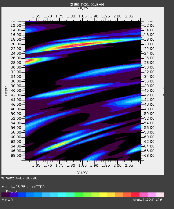
| Estimated Moho Depth: |
26.75 km |
| Estimated Crust Vp/Vs: |
1.60 |
| Assumed Crust Vp: |
6.121 km/s |
| Estimated Crust Vs: |
3.825 km/s |
| Estimated Crust Poisson's Ratio: |
0.18 |
|
| Radial Match: |
87.88798 % |
| Radial Bump: |
400 |
| Transverse Match: |
63.963318 % |
| Transverse Bump: |
400 |
| SOD ConfigId: |
27569 |
| Insert Time: |
2010-02-26 17:32:36.685 +0000 |
| GWidth: |
2.5 |
| Max Bumps: |
400 |
| Tol: |
0.001 |
|

Signal To Noise
| Channel | StoN | STA | LTA |
| XM:TX01:01:BHN:20001212T05:32:38.981992Z | 1.7134261 | 4.436161E-7 | 2.5890589E-7 |
| XM:TX01:01:BHE:20001212T05:32:38.981992Z | 0.6334991 | 2.852855E-7 | 4.5033292E-7 |
| XM:TX01:01:BHZ:20001212T05:32:38.981992Z | 2.6933765 | 5.992175E-7 | 2.2247818E-7 |
| Arrivals |
| Ps | 2.8 SECOND |
| PpPs | 10 SECOND |
| PsPs/PpSs | 13 SECOND |


