
Station XM TX01 - Texas01
Network: XM99 - Rio Grande Seismic Transect
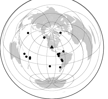
Nearby stations (2 deg radius)
| Station | Name | (Lat, Lon) | Start / End | Elevation |
| TX01 | Texas01 | (31.42, -103.11) | 1999-09-11 / 2001-12-31 | 750 m |
| Crust2 Type: | Q1,orogen/39km no ice, Appalachians, North Andes |
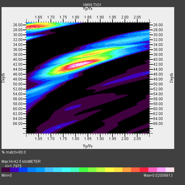
| Thickness Estimate: | 42 km |
| Thickness StdDev: | 6.9 km |
| Vp/Vs Estimate: | 1.80 |
| Vp/Vs StdDev: | 0.09 |
| Vs Estimate: | 3.405 km/s |
| Poisson's Ratio: | 0.28 |
| Peak Value: | 0.02 |
| Assumed Vp: | 6.121 km/s |
| Ps Weight: | 0.33333334 |
| PpPs Weight: | 0.33333334 |
| PsPs Weight: | 0.33333328 |
| Residual Complexity: | 0.697 |
| Nearby stations H: | +- |
| (2.0 deg) Vp/Vs: | +- |
6 with match > 90% ( 33.333332 %) and 16 with match > 80% ( 88.888885 %) out of 18.
Download stack as xyz text file.
Azimuth Distribution of Events:
Prior Results for this Station
| Study | Thickness | Vp/Vs | Vp | Vs | Poissons Ratio | Extra |
| EARS | 42 km | 1.80 | 6.121 km/s | 3.405 km/s | 0.28 | |
| Crust2.0 | 39 km | 1.76 | 6.121 km/s | 3.485 km/s | 0.26 | Q1,orogen/39km no ice, Appalachians, North Andes |
| Wilson | 44 km | 1.75 | 6.31 km/s | 3.606 km/s | 0.26 | |
| Global Maxima | 42 km | 1.80 | 6.121 km/s | 3.405 km/s | 0.28 | amp=0.02008613 |
| Local Maxima 1 | 27 km | 1.64 | 6.121 km/s | 3.726 km/s | 0.21 | amp=0.019232994 |
| Local Maxima 2 | 38 km | 1.85 | 6.121 km/s | 3.313 km/s | 0.29 | amp=0.011508335 |
| Local Maxima 3 | 40 km | 1.88 | 6.121 km/s | 3.256 km/s | 0.30 | amp=0.010287466 |
| Local Maxima 4 | 26 km | 1.61 | 6.121 km/s | 3.802 km/s | 0.19 | amp=0.009284428 |
| Predicted Arrivals for vertical incidence (zero ray parameter) | |
| Ps | 5.54 SECOND |
| PpPs | 19.43 SECOND |
| PsPs/PpSs | 24.96 SECOND |
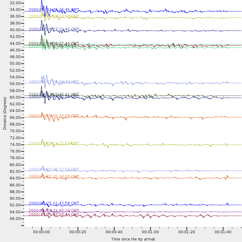
Events Processed for this Station
Download zip of receiver functions as SAC
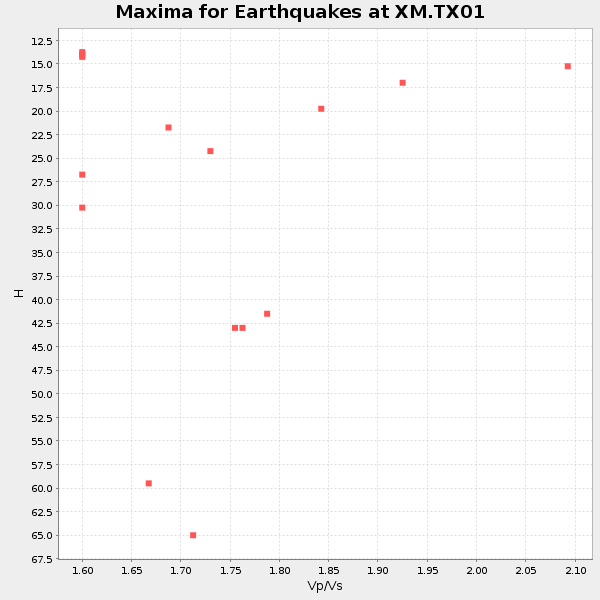
Plot maxima for each earthquake.
Events Used in the Stack
(16 events)| Radial Match | Distance | Baz | FERegion | Time | Lat/Lon | Depth | Magnitude |
| 97.69214 | 96.6 deg | 301.027 deg | Volcano Islands, Japan Region | 2000/03/28 11:00:22 GMT | (22.3, 143.7) | 126 km | 6.8 MB, 7.6 MS, 7.6 MW, 7.6 MW |
| 94.51833 | 83.3 deg | 245.374 deg | Tonga Islands | 2000/09/26 06:17:52 GMT | (-17.2, -173.9) | 56 km | 6.1 MB, 6.1 MS, 6.4 MW, 6.1 ME |
| 94.406166 | 38.0 deg | 141.549 deg | Near Coast Of Ecuador | 2000/09/28 23:23:43 GMT | (-0.2, -80.6) | 23 km | 5.8 MB, 6.0 MS, 6.6 MW, 6.4 MW |
| 91.94706 | 42.5 deg | 109.27 deg | Windward Islands | 2000/10/04 14:37:44 GMT | (11.1, -62.6) | 110 km | 5.6 MB, 5.4 MS, 6.1 MW, 5.9 MD |
| 91.80782 | 43.5 deg | 322.128 deg | Kodiak Island Region, Alaska | 1999/12/06 23:12:33 GMT | (57.4, -154.5) | 66 km | 6.8 MB, 7.0 MW, 7.0 ML |
| 91.757 | 59.7 deg | 142.258 deg | Northern Chile | 1999/11/30 04:01:53 GMT | (-18.9, -69.2) | 128 km | 6.2 MB, 6.6 MW, 6.5 MW |
| 87.88798 | 31.7 deg | 138.66 deg | South Of Panama | 2000/12/12 05:26:45 GMT | (6.0, -82.7) | 10 km | 5.8 MB, 5.7 MS, 6.3 ME, 6.1 MW |
| 86.86525 | 94.3 deg | 249.878 deg | Vanuatu Islands Region | 2000/02/25 01:43:58 GMT | (-19.5, 173.8) | 33 km | 6.1 MB, 7.1 MS, 7.1 MW, 7.0 MW |
| 86.10667 | 59.1 deg | 30.677 deg | Iceland | 2000/06/17 15:40:41 GMT | (64.0, -20.5) | 10 km | 5.7 MB, 6.6 MS, 6.8 MW, 6.5 MW |
| 84.06707 | 33.9 deg | 130.466 deg | Panama-Colombia Border Region | 2000/11/08 06:59:58 GMT | (7.0, -77.8) | 17 km | 6.0 MB, 6.4 MS, 6.5 MW, 6.2 ML |
| 83.9968 | 85.7 deg | 242.63 deg | Tonga Islands | 2000/01/02 15:16:32 GMT | (-20.8, -174.2) | 33 km | 5.5 MB, 5.8 MS, 5.8 MW, 5.8 MW |
| 83.98095 | 74.9 deg | 157.397 deg | Off Coast Of Central Chile | 2000/12/20 11:23:54 GMT | (-39.0, -74.7) | 11 km | 6.1 MB, 6.2 MS, 6.4 MW, 6.0 ME |
| 83.896515 | 55.0 deg | 141.424 deg | Central Peru | 1999/11/27 02:31:49 GMT | (-14.5, -71.3) | 126 km | 5.8 MB, 5.9 MW, 5.9 MW |
| 83.55561 | 97.9 deg | 256.809 deg | Vanuatu Islands | 2000/10/04 16:58:44 GMT | (-15.4, 166.9) | 23 km | 6.1 MB, 6.9 MS, 6.8 MW, 6.5 ME |
| 82.698784 | 66.0 deg | 185.907 deg | Southern East Pacific Rise | 2000/10/25 05:26:38 GMT | (-34.6, -109.6) | 10 km | 5.6 MB, 5.7 MS, 6.0 MW, 6.0 MW |
| 82.5682 | 42.8 deg | 321.908 deg | Kodiak Island Region, Alaska | 2001/01/10 16:02:44 GMT | (57.1, -153.2) | 33 km | 6.2 MB, 6.8 MS, 7.1 MW, 6.8 ML |
Losers
(2 events)| Radial Match | Distance | Baz | FERegion | Time | Lat/Lon | Depth | Magnitude | Reason |
| 81.8226 | 92.3 deg | 312.794 deg | Near S. Coast Of Honshu, Japan | 2000/07/01 07:01:55 GMT | (34.2, 139.1) | 10 km | 6.0 MB, 6.1 MS, 6.2 MW, 6.2 MW | |
| 80.501396 | 72.9 deg | 321.708 deg | Northwest Of Kuril Islands | 2001/02/07 15:16:15 GMT | (52.8, 153.8) | 427 km | 5.6 MB, 5.8 MW, 5.7 MW |
