You are here: Home > Network List > XM99 - Rio Grande Seismic Transect Stations List
> Station TX01 Texas01 > Earthquake Result Viewer
TX01 Texas01 - Earthquake Result Viewer
| Earthquake location: |
Windward Islands |
| Earthquake latitude/longitude: |
11.1/-62.6 |
| Earthquake time(UTC): |
2000/10/04 (278) 14:37:44 GMT |
| Earthquake Depth: |
110 km |
| Earthquake Magnitude: |
5.6 MB, 5.4 MS, 6.1 MW, 5.9 MD |
| Earthquake Catalog/Contributor: |
WHDF/NEIC |
|
| Network: |
XM Rio Grande Seismic Transect |
| Station: |
TX01 Texas01 |
| Lat/Lon: |
31.42 N/103.11 W |
| Elevation: |
750 m |
|
| Distance: |
42.5 deg |
| Az: |
304.69 deg |
| Baz: |
109.27 deg |
| Ray Param: |
0.07274384 |
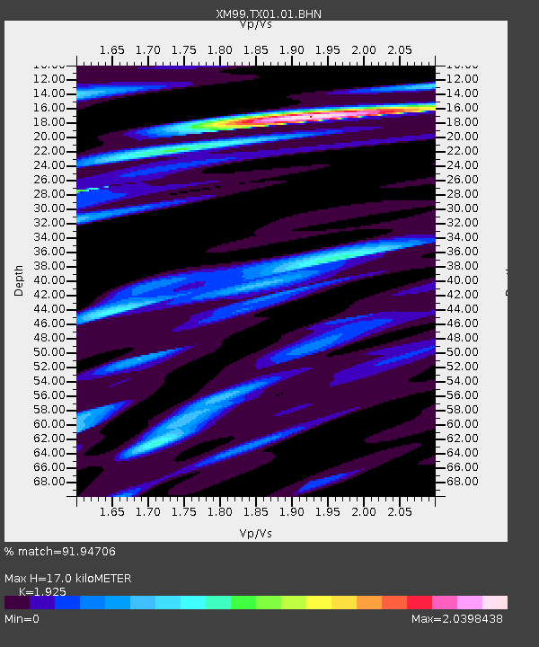
| Estimated Moho Depth: |
17.0 km |
| Estimated Crust Vp/Vs: |
1.92 |
| Assumed Crust Vp: |
6.121 km/s |
| Estimated Crust Vs: |
3.179 km/s |
| Estimated Crust Poisson's Ratio: |
0.32 |
|
| Radial Match: |
91.94706 % |
| Radial Bump: |
400 |
| Transverse Match: |
86.43174 % |
| Transverse Bump: |
400 |
| SOD ConfigId: |
16820 |
| Insert Time: |
2010-02-26 17:32:41.213 +0000 |
| GWidth: |
2.5 |
| Max Bumps: |
400 |
| Tol: |
0.001 |
|

Signal To Noise
| Channel | StoN | STA | LTA |
| XM:TX01:01:BHN:20001004T14:44:58.303015Z | 2.155681 | 3.0693528E-7 | 1.4238438E-7 |
| XM:TX01:01:BHE:20001004T14:44:58.303015Z | 7.3972483 | 1.3719354E-6 | 1.8546564E-7 |
| XM:TX01:01:BHZ:20001004T14:44:58.303015Z | 8.020014 | 2.0863113E-6 | 2.6013814E-7 |
| Arrivals |
| Ps | 2.7 SECOND |
| PpPs | 7.7 SECOND |
| PsPs/PpSs | 10 SECOND |


