You are here: Home > Network List > XM99 - Rio Grande Seismic Transect Stations List
> Station TX01 Texas01 > Earthquake Result Viewer
TX01 Texas01 - Earthquake Result Viewer

| Earthquake location: |
Vanuatu Islands Region |
| Earthquake latitude/longitude: |
-19.5/173.8 |
| Earthquake time(UTC): |
2000/02/25 (056) 01:43:58 GMT |
| Earthquake Depth: |
33 km |
| Earthquake Magnitude: |
6.1 MB, 7.1 MS, 7.1 MW, 7.0 MW |
| Earthquake Catalog/Contributor: |
WHDF/NEIC |
|
| Network: |
XM Rio Grande Seismic Transect |
| Station: |
TX01 Texas01 |
| Lat/Lon: |
31.42 N/103.11 W |
| Elevation: |
750 m |
|
| Distance: |
94.3 deg |
| Az: |
58.328 deg |
| Baz: |
249.878 deg |
| Ray Param: |
0.041060083 |
| Estimated Moho Depth: |
21.75 km |
| Estimated Crust Vp/Vs: |
1.69 |
| Assumed Crust Vp: |
6.121 km/s |
| Estimated Crust Vs: |
3.627 km/s |
| Estimated Crust Poisson's Ratio: |
0.23 |
|
| Radial Match: |
86.86525 % |
| Radial Bump: |
400 |
| Transverse Match: |
58.505264 % |
| Transverse Bump: |
400 |
| SOD ConfigId: |
27569 |
| Insert Time: |
2010-02-26 17:32:47.151 +0000 |
| GWidth: |
2.5 |
| Max Bumps: |
400 |
| Tol: |
0.001 |
|
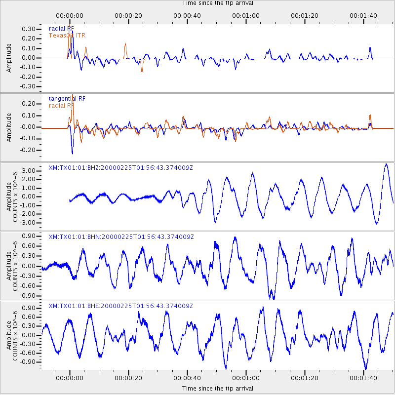
Signal To Noise
| Channel | StoN | STA | LTA |
| XM:TX01:01:BHN:20000225T01:56:43.374009Z | 1.4940726 | 2.7692496E-7 | 1.8534908E-7 |
| XM:TX01:01:BHE:20000225T01:56:43.374009Z | 2.3877974 | 4.5555055E-7 | 1.9078274E-7 |
| XM:TX01:01:BHZ:20000225T01:56:43.374009Z | 1.3374077 | 4.189293E-7 | 3.1323978E-7 |
| Arrivals |
| Ps | 2.5 SECOND |
| PpPs | 9.4 SECOND |
| PsPs/PpSs | 12 SECOND |


