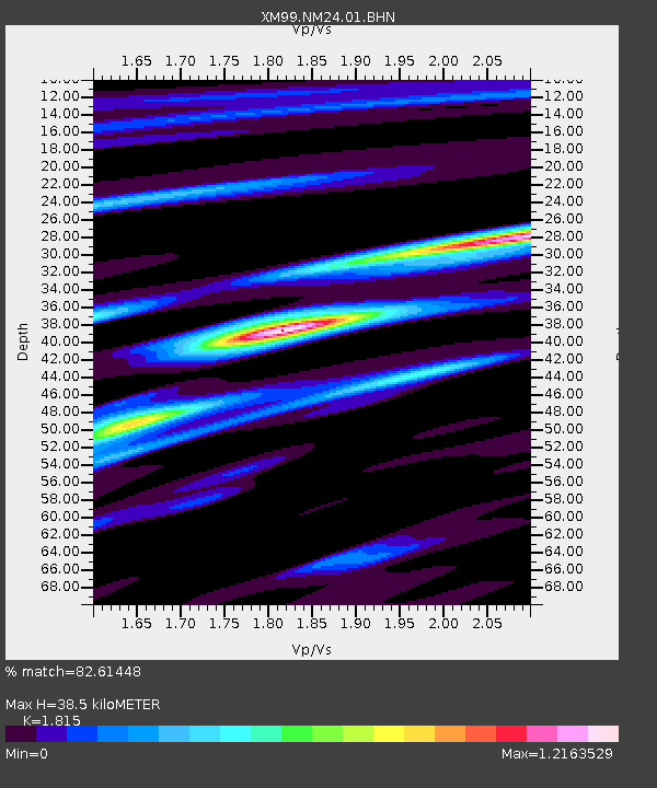
NM24 NewMexico24 - Earthquake Result Viewer

Earthquake location: Tonga Islands
Earthquake latitude/longitude: -17.3/-174.0
Earthquake time(UTC): 2000/01/26 (026) 13:26:50 GMT
Earthquake Depth: 33 km
Earthquake Magnitude: 5.9 MB, 6.0 MS, 6.4 MW, 6.3 MW
Earthquake Catalog/Contributor: WHDF/NEIC
Network: XM Rio Grande Seismic Transect
Station: NM24 NewMexico24
Lat/Lon: 34.05 N/106.12 W
Elevation: 1874 m
Distance: 82.3 deg
Az: 50.918 deg
Baz: 243.284 deg
Ray Param: 0.046949476
Estimated Moho Depth: 38.5 km
Estimated Crust Vp/Vs: 1.82
Assumed Crust Vp: 6.502 km/s
Estimated Crust Vs: 3.582 km/s
Estimated Crust Poisson's Ratio: 0.28
Radial Match: 82.61448 %
Radial Bump: 384
Transverse Match: 65.362976 %
Transverse Bump: 400
SOD ConfigId: 27569
Insert Time: 2010-02-26 17:33:47.383 +0000
GWidth: 2.5
Max Bumps: 400
Tol: 0.001

Signal To Noise

ChannelStoNSTALTA
XM:NM24:01:BHN:20000126T13:38:37.02002Z1.19401383.186186E-72.6684665E-7
XM:NM24:01:BHE:20000126T13:38:37.02002Z0.582976641.592995E-72.7325194E-7
XM:NM24:01:BHZ:20000126T13:38:37.02002Z0.33693688.211346E-82.437058E-7
Arrivals
Ps5.0 SECOND
PpPs16 SECOND
PsPs/PpSs21 SECOND