
Station XM NM24 - NewMexico24
Network: XM99 - Rio Grande Seismic Transect
Nearby stations (2 deg radius)
| Station | Name | (Lat, Lon) | Start / End | Elevation |
| NM24 | NewMexico24 | (34.05, -106.12) | 1999-10-02 / 2001-12-31 | 1874 m |
| Crust2 Type: | X2,Rift, Rio Grande, Baikal, 0.5km sediments |
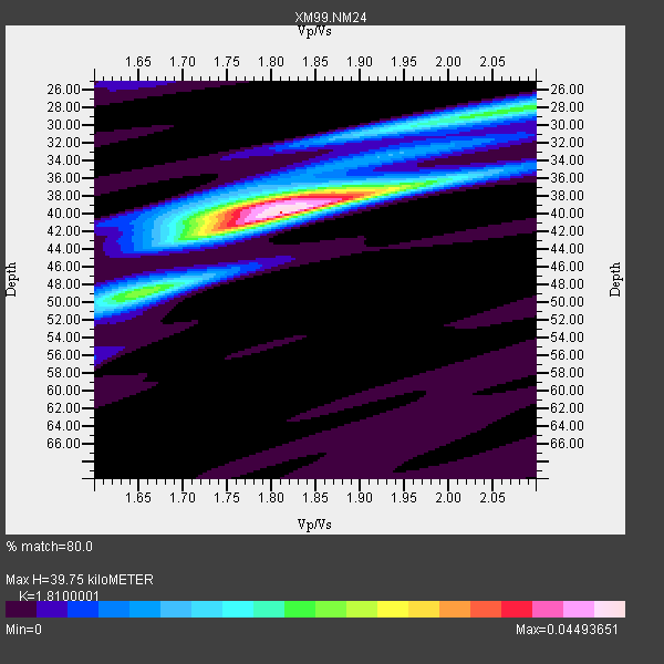
| Thickness Estimate: | 40 km |
| Thickness StdDev: | 2.1 km |
| Vp/Vs Estimate: | 1.81 |
| Vp/Vs StdDev: | 0.04 |
| Vs Estimate: | 3.592 km/s |
| Poisson's Ratio: | 0.28 |
| Peak Value: | 0.04 |
| Assumed Vp: | 6.502 km/s |
| Ps Weight: | 0.33333334 |
| PpPs Weight: | 0.33333334 |
| PsPs Weight: | 0.33333328 |
| Residual Complexity: | 0.555 |
| Nearby stations H: | +- |
| (2.0 deg) Vp/Vs: | +- |
5 with match > 90% ( 27.777779 %) and 18 with match > 80% ( 100.0 %) out of 18.
Download stack as xyz text file.
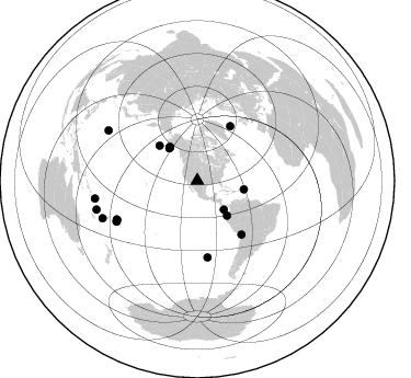
Azimuth Distribution of Events:
Prior Results for this Station
| Study | Thickness | Vp/Vs | Vp | Vs | Poissons Ratio | Extra |
| EARS | 40 km | 1.81 | 6.502 km/s | 3.592 km/s | 0.28 | |
| Crust2.0 | 33 km | 1.77 | 6.502 km/s | 3.68 km/s | 0.26 | X2,Rift, Rio Grande, Baikal, 0.5km sediments |
| Wilson | 38 km | 1.78 | 6.19 km/s | 3.478 km/s | 0.27 | |
| Global Maxima | 40 km | 1.81 | 6.502 km/s | 3.592 km/s | 0.28 | amp=0.04493651 |
| Local Maxima 1 | 39 km | 1.80 | 6.502 km/s | 3.617 km/s | 0.28 | amp=0.028046168 |
| Local Maxima 2 | 28 km | 2.07 | 6.502 km/s | 3.145 km/s | 0.35 | amp=0.020516928 |
| Local Maxima 3 | 49 km | 1.64 | 6.502 km/s | 3.964 km/s | 0.20 | amp=0.015189244 |
| Local Maxima 4 | 31 km | 1.90 | 6.502 km/s | 3.426 km/s | 0.31 | amp=0.008249193 |
| Predicted Arrivals for vertical incidence (zero ray parameter) | |
| Ps | 4.95 SECOND |
| PpPs | 17.18 SECOND |
| PsPs/PpSs | 22.13 SECOND |
Events Processed for this Station
Download zip of receiver functions as SAC
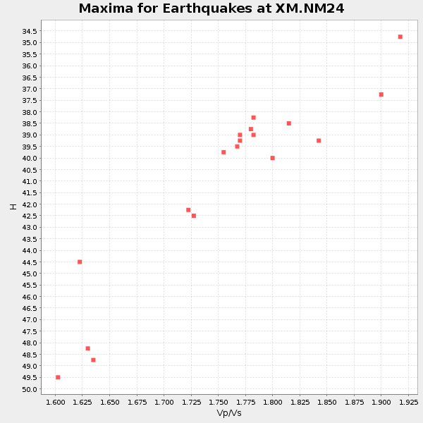
Plot maxima for each earthquake.
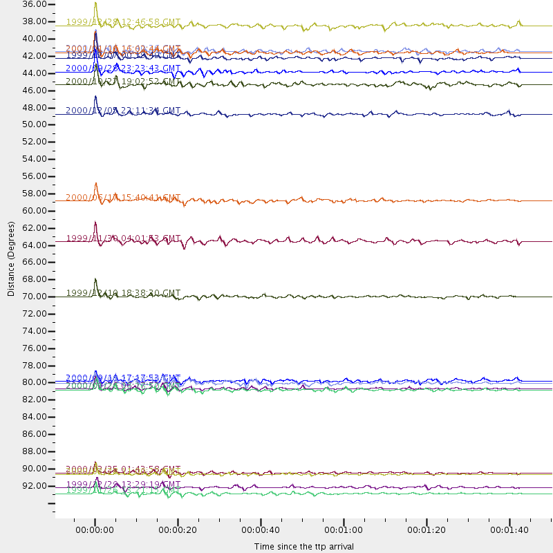
Events Used in the Stack
(18 events)| Radial Match | Distance | Baz | FERegion | Time | Lat/Lon | Depth | Magnitude |
| 97.99976 | 93.1 deg | 299.488 deg | Volcano Islands, Japan Region | 2000/03/28 11:00:22 GMT | (22.3, 143.7) | 126 km | 6.8 MB, 7.6 MS, 7.6 MW, 7.6 MW |
| 96.198425 | 95.5 deg | 254.038 deg | Vanuatu Islands | 1999/11/26 13:21:15 GMT | (-16.4, 168.2) | 33 km | 6.4 MB, 7.3 MS, 7.5 MW, 7.3 MW |
| 95.43565 | 82.2 deg | 243.311 deg | Tonga Islands | 2000/09/26 06:17:52 GMT | (-17.2, -173.9) | 56 km | 6.1 MB, 6.1 MS, 6.4 MW, 6.1 ME |
| 94.477005 | 41.7 deg | 139.566 deg | Near Coast Of Ecuador | 2000/09/28 23:23:43 GMT | (-0.2, -80.6) | 23 km | 5.8 MB, 6.0 MS, 6.6 MW, 6.4 MW |
| 92.803474 | 39.1 deg | 320.685 deg | Kodiak Island Region, Alaska | 2001/01/10 16:02:44 GMT | (57.1, -153.2) | 33 km | 6.2 MB, 6.8 MS, 7.1 MW, 6.8 ML |
| 87.9123 | 58.1 deg | 31.206 deg | Iceland | 2000/06/17 15:40:41 GMT | (64.0, -20.5) | 10 km | 5.7 MB, 6.6 MS, 6.8 MW, 6.5 MW |
| 85.77507 | 63.3 deg | 140.445 deg | Northern Chile | 1999/11/30 04:01:53 GMT | (-18.9, -69.2) | 128 km | 6.2 MB, 6.6 MW, 6.5 MW |
| 85.33045 | 39.9 deg | 320.828 deg | Kodiak Island Region, Alaska | 1999/12/07 00:19:49 GMT | (57.4, -154.5) | 41 km | 6.5 MB, 6.1 MS, 6.4 MW, 6.3 ML |
| 85.23869 | 92.9 deg | 248.465 deg | Vanuatu Islands Region | 2000/02/25 01:43:58 GMT | (-19.5, 173.8) | 33 km | 6.1 MB, 7.1 MS, 7.1 MW, 7.0 MW |
| 84.58455 | 47.0 deg | 312.742 deg | Fox Islands, Aleutian Islands | 2000/12/05 22:11:34 GMT | (52.6, -167.8) | 33 km | 5.6 MB, 5.6 MS, 5.9 MW, 5.4 ML |
| 84.491104 | 81.2 deg | 244.182 deg | Tonga Islands | 2000/09/11 17:17:53 GMT | (-15.9, -173.7) | 115 km | 6.0 MB, 6.3 MW, 6.3 MW |
| 83.67492 | 70.4 deg | 172.448 deg | West Chile Rise | 1999/12/10 18:38:30 GMT | (-36.2, -97.3) | 10 km | 5.7 MB, 6.2 MS, 6.5 MW, 6.5 MW |
| 83.62448 | 81.4 deg | 244.335 deg | Tonga Islands | 1999/12/07 21:29:49 GMT | (-15.9, -174.0) | 138 km | 6.2 MB, 6.4 MW, 6.4 MW |
| 82.61448 | 82.3 deg | 243.284 deg | Tonga Islands | 2000/01/26 13:26:50 GMT | (-17.3, -174.0) | 33 km | 5.9 MB, 6.0 MS, 6.4 MW, 6.3 MW |
| 82.33152 | 43.3 deg | 100.664 deg | Leeward Islands | 2000/10/27 19:02:52 GMT | (17.6, -61.2) | 38 km | 5.4 MB, 5.3 MS, 5.8 MW, 5.6 MW |
| 81.79934 | 94.8 deg | 260.206 deg | Santa Cruz Islands | 1999/12/29 13:29:19 GMT | (-10.9, 165.4) | 33 km | 5.6 MB, 6.8 MS, 6.8 MW, 6.3 MW |
| 81.77786 | 39.0 deg | 319.204 deg | Kodiak Island Region, Alaska | 2000/11/06 11:40:26 GMT | (56.2, -153.5) | 20 km | 5.5 MB, 5.6 MS, 6.0 MW, 5.5 ML |
| 80.894135 | 35.7 deg | 137.2 deg | South Of Panama | 1999/12/28 12:46:58 GMT | (5.6, -82.6) | 10 km | 5.4 MB, 5.5 MS, 5.9 MW, 5.5 ML |
Losers
(0 events)| Radial Match | Distance | Baz | FERegion | Time | Lat/Lon | Depth | Magnitude | Reason |
