You are here: Home > Network List > XM99 - Rio Grande Seismic Transect Stations List
> Station NM24 NewMexico24 > Earthquake Result Viewer
NM24 NewMexico24 - Earthquake Result Viewer
| Earthquake location: |
Tonga Islands |
| Earthquake latitude/longitude: |
-15.9/-174.0 |
| Earthquake time(UTC): |
1999/12/07 (341) 21:29:49 GMT |
| Earthquake Depth: |
138 km |
| Earthquake Magnitude: |
6.2 MB, 6.4 MW, 6.4 MW |
| Earthquake Catalog/Contributor: |
WHDF/NEIC |
|
| Network: |
XM Rio Grande Seismic Transect |
| Station: |
NM24 NewMexico24 |
| Lat/Lon: |
34.05 N/106.12 W |
| Elevation: |
1874 m |
|
| Distance: |
81.4 deg |
| Az: |
51.062 deg |
| Baz: |
244.335 deg |
| Ray Param: |
0.047275405 |
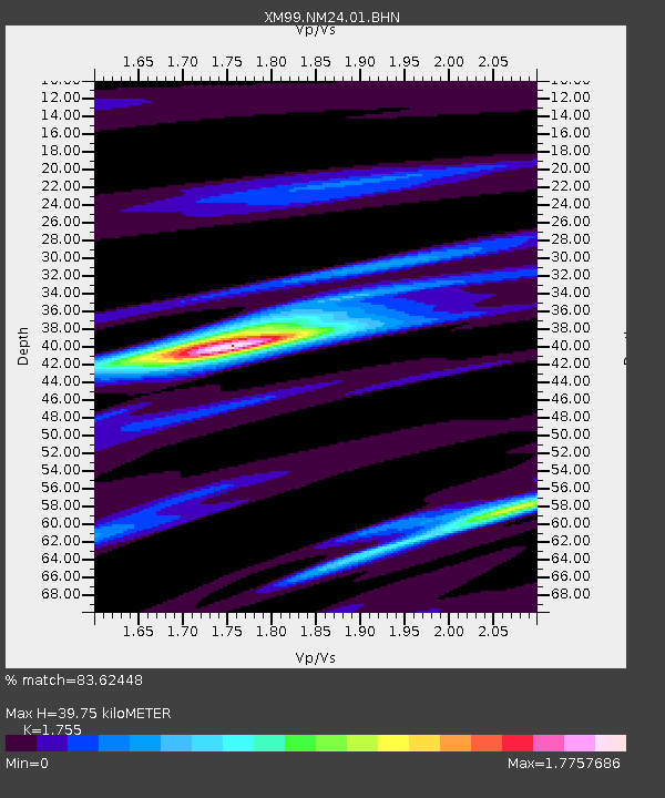
| Estimated Moho Depth: |
39.75 km |
| Estimated Crust Vp/Vs: |
1.75 |
| Assumed Crust Vp: |
6.502 km/s |
| Estimated Crust Vs: |
3.705 km/s |
| Estimated Crust Poisson's Ratio: |
0.26 |
|
| Radial Match: |
83.62448 % |
| Radial Bump: |
400 |
| Transverse Match: |
63.019165 % |
| Transverse Bump: |
400 |
| SOD ConfigId: |
27569 |
| Insert Time: |
2010-02-26 17:34:00.642 +0000 |
| GWidth: |
2.5 |
| Max Bumps: |
400 |
| Tol: |
0.001 |
|

Signal To Noise
| Channel | StoN | STA | LTA |
| XM:NM24:01:BHN:19991207T21:41:19.788005Z | 2.064102 | 3.4365945E-7 | 1.6649346E-7 |
| XM:NM24:01:BHE:19991207T21:41:19.788005Z | 2.1510394 | 3.4848355E-7 | 1.6200705E-7 |
| XM:NM24:01:BHZ:19991207T21:41:19.788005Z | 11.415938 | 1.6432583E-6 | 1.4394422E-7 |
| Arrivals |
| Ps | 4.7 SECOND |
| PpPs | 16 SECOND |
| PsPs/PpSs | 21 SECOND |


