You are here: Home > Network List > XM99 - Rio Grande Seismic Transect Stations List
> Station TX03 Texas03 > Earthquake Result Viewer
TX03 Texas03 - Earthquake Result Viewer
| Earthquake location: |
Tonga Islands |
| Earthquake latitude/longitude: |
-17.3/-174.0 |
| Earthquake time(UTC): |
2000/01/26 (026) 13:26:50 GMT |
| Earthquake Depth: |
33 km |
| Earthquake Magnitude: |
5.9 MB, 6.0 MS, 6.4 MW, 6.3 MW |
| Earthquake Catalog/Contributor: |
WHDF/NEIC |
|
| Network: |
XM Rio Grande Seismic Transect |
| Station: |
TX03 Texas03 |
| Lat/Lon: |
31.62 N/103.32 W |
| Elevation: |
831 m |
|
| Distance: |
83.4 deg |
| Az: |
54.143 deg |
| Baz: |
245.196 deg |
| Ray Param: |
0.046203107 |
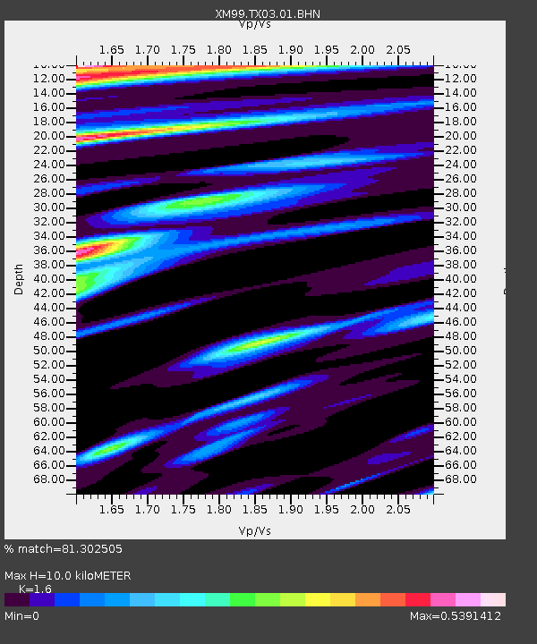
| Estimated Moho Depth: |
10.0 km |
| Estimated Crust Vp/Vs: |
1.60 |
| Assumed Crust Vp: |
6.121 km/s |
| Estimated Crust Vs: |
3.825 km/s |
| Estimated Crust Poisson's Ratio: |
0.18 |
|
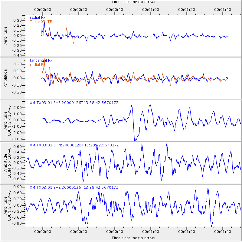
| Radial Match: |
81.302505 % |
| Radial Bump: |
392 |
| Transverse Match: |
61.39397 % |
| Transverse Bump: |
400 |
| SOD ConfigId: |
27569 |
| Insert Time: |
2010-02-26 17:34:05.037 +0000 |
| GWidth: |
2.5 |
| Max Bumps: |
400 |
| Tol: |
0.001 |
|
Signal To Noise
| Channel | StoN | STA | LTA |
| XM:TX03:01:BHN:20000126T13:38:42.567017Z | 0.4888197 | 8.589346E-8 | 1.7571605E-7 |
| XM:TX03:01:BHE:20000126T13:38:42.567017Z | 1.7787609 | 2.4153164E-7 | 1.3578645E-7 |
| XM:TX03:01:BHZ:20000126T13:38:42.567017Z | 1.6012999 | 3.0129408E-7 | 1.8815594E-7 |
| Arrivals |
| Ps | 1.0 SECOND |
| PpPs | 4.1 SECOND |
| PsPs/PpSs | 5.1 SECOND |


