
Station XM TX03 - Texas03
Network: XM99 - Rio Grande Seismic Transect
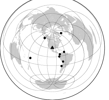
Nearby stations (2 deg radius)
| Station | Name | (Lat, Lon) | Start / End | Elevation |
| TX03 | Texas03 | (31.62, -103.32) | 1999-09-01 / 2001-12-31 | 831 m |
| Crust2 Type: | Q1,orogen/39km no ice, Appalachians, North Andes |
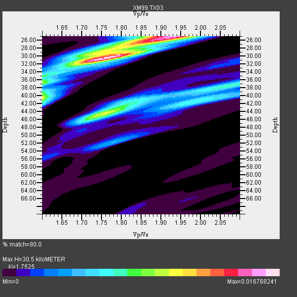
| Thickness Estimate: | 30 km |
| Thickness StdDev: | 5.9 km |
| Vp/Vs Estimate: | 1.75 |
| Vp/Vs StdDev: | 0.13 |
| Vs Estimate: | 3.492 km/s |
| Poisson's Ratio: | 0.26 |
| Peak Value: | 0.02 |
| Assumed Vp: | 6.121 km/s |
| Ps Weight: | 0.33333334 |
| PpPs Weight: | 0.33333334 |
| PsPs Weight: | 0.33333328 |
| Residual Complexity: | 0.714 |
| Nearby stations H: | +- |
| (2.0 deg) Vp/Vs: | +- |
4 with match > 90% ( 36.363636 %) and 10 with match > 80% ( 90.90909 %) out of 11.
Download stack as xyz text file.
Azimuth Distribution of Events:
Prior Results for this Station
| Study | Thickness | Vp/Vs | Vp | Vs | Poissons Ratio | Extra |
| EARS | 30 km | 1.75 | 6.121 km/s | 3.492 km/s | 0.26 | |
| Crust2.0 | 39 km | 1.76 | 6.121 km/s | 3.485 km/s | 0.26 | Q1,orogen/39km no ice, Appalachians, North Andes |
| Wilson | 44 km | 1.75 | 6.29 km/s | 3.594 km/s | 0.26 | |
| Global Maxima | 30 km | 1.75 | 6.121 km/s | 3.492 km/s | 0.26 | amp=0.016768241 |
| Local Maxima 1 | 25 km | 1.93 | 6.121 km/s | 3.167 km/s | 0.32 | amp=0.013130903 |
| Local Maxima 2 | 44 km | 1.76 | 6.121 km/s | 3.478 km/s | 0.26 | amp=0.010232604 |
| Local Maxima 3 | 40 km | 1.60 | 6.121 km/s | 3.825 km/s | 0.18 | amp=0.009300588 |
| Local Maxima 4 | 38 km | 2.07 | 6.121 km/s | 2.957 km/s | 0.35 | amp=0.006790352 |
| Predicted Arrivals for vertical incidence (zero ray parameter) | |
| Ps | 3.75 SECOND |
| PpPs | 13.72 SECOND |
| PsPs/PpSs | 17.47 SECOND |
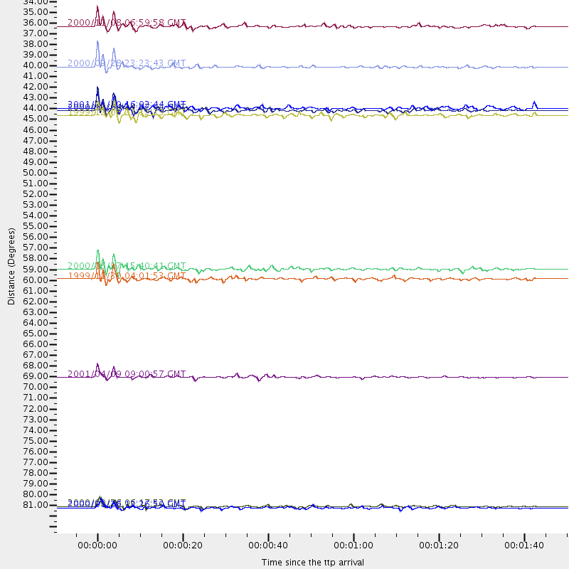
Events Processed for this Station
Download zip of receiver functions as SAC
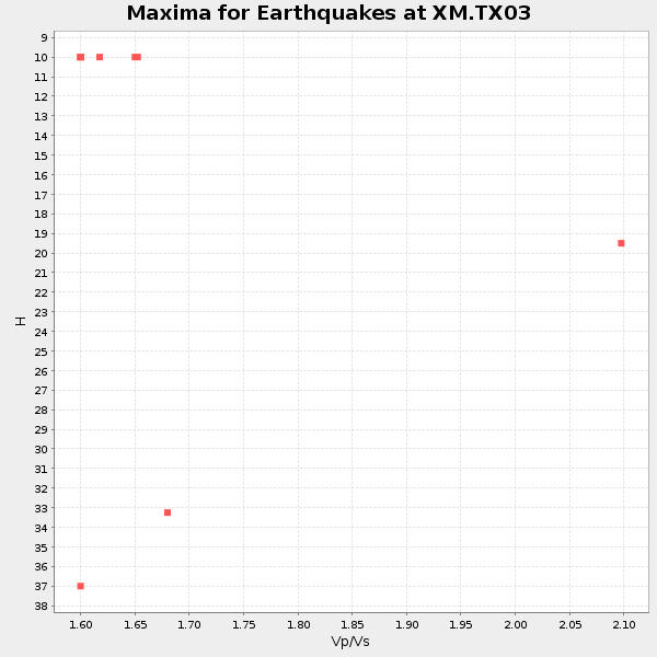
Plot maxima for each earthquake.
Events Used in the Stack
(10 events)| Radial Match | Distance | Baz | FERegion | Time | Lat/Lon | Depth | Magnitude |
| 94.405464 | 43.3 deg | 322.04 deg | Kodiak Island Region, Alaska | 1999/12/06 23:12:33 GMT | (57.4, -154.5) | 66 km | 6.8 MB, 7.0 MW, 7.0 ML |
| 92.853516 | 38.3 deg | 141.408 deg | Near Coast Of Ecuador | 2000/09/28 23:23:43 GMT | (-0.2, -80.6) | 23 km | 5.8 MB, 6.0 MS, 6.6 MW, 6.4 MW |
| 92.81105 | 83.2 deg | 245.23 deg | Tonga Islands | 2000/09/26 06:17:52 GMT | (-17.2, -173.9) | 56 km | 6.1 MB, 6.1 MS, 6.4 MW, 6.1 ME |
| 92.20327 | 42.8 deg | 109.294 deg | Windward Islands | 2000/10/04 14:37:44 GMT | (11.1, -62.6) | 110 km | 5.6 MB, 5.4 MS, 6.1 MW, 5.9 MD |
| 89.084885 | 70.0 deg | 153.153 deg | Off Coast Of Central Chile | 2001/04/09 09:00:57 GMT | (-32.7, -73.1) | 11 km | 6.1 MB, 6.3 MS, 6.7 MW, 6.3 ME |
| 87.83409 | 34.1 deg | 130.398 deg | Panama-Colombia Border Region | 2000/11/08 06:59:58 GMT | (7.0, -77.8) | 17 km | 6.0 MB, 6.4 MS, 6.5 MW, 6.2 ML |
| 86.78189 | 59.0 deg | 30.72 deg | Iceland | 2000/06/17 15:40:41 GMT | (64.0, -20.5) | 10 km | 5.7 MB, 6.6 MS, 6.8 MW, 6.5 MW |
| 86.53597 | 60.0 deg | 142.13 deg | Northern Chile | 1999/11/30 04:01:53 GMT | (-18.9, -69.2) | 128 km | 6.2 MB, 6.6 MW, 6.5 MW |
| 82.10235 | 42.5 deg | 321.82 deg | Kodiak Island Region, Alaska | 2001/01/10 16:02:44 GMT | (57.1, -153.2) | 33 km | 6.2 MB, 6.8 MS, 7.1 MW, 6.8 ML |
| 81.302505 | 83.4 deg | 245.196 deg | Tonga Islands | 2000/01/26 13:26:50 GMT | (-17.3, -174.0) | 33 km | 5.9 MB, 6.0 MS, 6.4 MW, 6.3 MW |
Losers
(1 events)| Radial Match | Distance | Baz | FERegion | Time | Lat/Lon | Depth | Magnitude | Reason |
| 82.90464 | 90.4 deg | 323.013 deg | E. Russia-N.E. China Border Reg. | 2000/02/13 02:57:08 GMT | (42.9, 131.6) | 514 km | 5.4 MB, 6.0 MW, 6.0 MW |
