You are here: Home > Network List > XM99 - Rio Grande Seismic Transect Stations List
> Station TX03 Texas03 > Earthquake Result Viewer
TX03 Texas03 - Earthquake Result Viewer

| Earthquake location: |
Iceland |
| Earthquake latitude/longitude: |
64.0/-20.5 |
| Earthquake time(UTC): |
2000/06/17 (169) 15:40:41 GMT |
| Earthquake Depth: |
10 km |
| Earthquake Magnitude: |
5.7 MB, 6.6 MS, 6.8 MW, 6.5 MW |
| Earthquake Catalog/Contributor: |
WHDF/NEIC |
|
| Network: |
XM Rio Grande Seismic Transect |
| Station: |
TX03 Texas03 |
| Lat/Lon: |
31.62 N/103.32 W |
| Elevation: |
831 m |
|
| Distance: |
59.0 deg |
| Az: |
279.048 deg |
| Baz: |
30.72 deg |
| Ray Param: |
0.062483814 |
| Estimated Moho Depth: |
10.0 km |
| Estimated Crust Vp/Vs: |
1.60 |
| Assumed Crust Vp: |
6.121 km/s |
| Estimated Crust Vs: |
3.825 km/s |
| Estimated Crust Poisson's Ratio: |
0.18 |
|
| Radial Match: |
86.78189 % |
| Radial Bump: |
400 |
| Transverse Match: |
69.38329 % |
| Transverse Bump: |
400 |
| SOD ConfigId: |
27569 |
| Insert Time: |
2010-02-26 17:34:07.635 +0000 |
| GWidth: |
2.5 |
| Max Bumps: |
400 |
| Tol: |
0.001 |
|
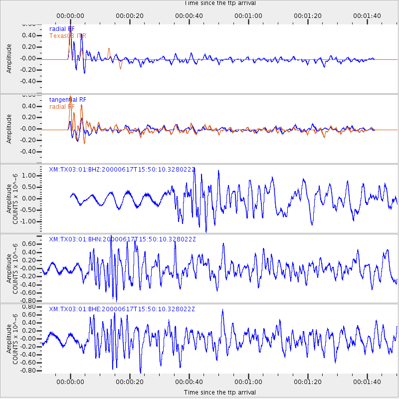
Signal To Noise
| Channel | StoN | STA | LTA |
| XM:TX03:01:BHN:20000617T15:50:10.328022Z | 1.1430728 | 1.323474E-7 | 1.1578211E-7 |
| XM:TX03:01:BHE:20000617T15:50:10.328022Z | 1.2575155 | 1.4679166E-7 | 1.1673148E-7 |
| XM:TX03:01:BHZ:20000617T15:50:10.328022Z | 1.4454966 | 2.916401E-7 | 2.0175771E-7 |
| Arrivals |
| Ps | 1.0 SECOND |
| PpPs | 4.0 SECOND |
| PsPs/PpSs | 5.1 SECOND |


