You are here: Home > Network List > XM99 - Rio Grande Seismic Transect Stations List
> Station TX03 Texas03 > Earthquake Result Viewer
TX03 Texas03 - Earthquake Result Viewer
| Earthquake location: |
Tonga Islands |
| Earthquake latitude/longitude: |
-17.2/-173.9 |
| Earthquake time(UTC): |
2000/09/26 (270) 06:17:52 GMT |
| Earthquake Depth: |
56 km |
| Earthquake Magnitude: |
6.1 MB, 6.1 MS, 6.4 MW, 6.1 ME |
| Earthquake Catalog/Contributor: |
WHDF/NEIC |
|
| Network: |
XM Rio Grande Seismic Transect |
| Station: |
TX03 Texas03 |
| Lat/Lon: |
31.62 N/103.32 W |
| Elevation: |
831 m |
|
| Distance: |
83.2 deg |
| Az: |
54.124 deg |
| Baz: |
245.23 deg |
| Ray Param: |
0.046224706 |
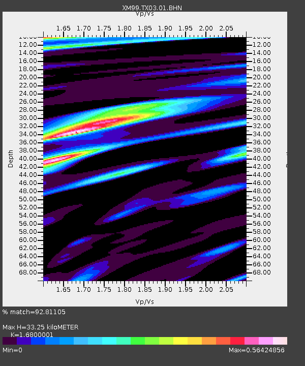
| Estimated Moho Depth: |
33.25 km |
| Estimated Crust Vp/Vs: |
1.68 |
| Assumed Crust Vp: |
6.121 km/s |
| Estimated Crust Vs: |
3.643 km/s |
| Estimated Crust Poisson's Ratio: |
0.23 |
|
| Radial Match: |
92.81105 % |
| Radial Bump: |
400 |
| Transverse Match: |
87.26316 % |
| Transverse Bump: |
400 |
| SOD ConfigId: |
16820 |
| Insert Time: |
2010-02-26 17:34:11.353 +0000 |
| GWidth: |
2.5 |
| Max Bumps: |
400 |
| Tol: |
0.001 |
|

Signal To Noise
| Channel | StoN | STA | LTA |
| XM:TX03:01:BHN:20000926T06:29:41.725002Z | 2.5475326 | 1.9681964E-7 | 7.725893E-8 |
| XM:TX03:01:BHE:20000926T06:29:41.725002Z | 4.7678347 | 3.4204578E-7 | 7.1740274E-8 |
| XM:TX03:01:BHZ:20000926T06:29:41.725002Z | 14.985292 | 1.7125435E-6 | 1.1428162E-7 |
| Arrivals |
| Ps | 3.8 SECOND |
| PpPs | 14 SECOND |
| PsPs/PpSs | 18 SECOND |


