You are here: Home > Network List > XK99 - CDROM (Colorado) Stations List
> Station N00 North 00 > Earthquake Result Viewer
N00 North 00 - Earthquake Result Viewer
| Earthquake location: |
Kermadec Islands Region |
| Earthquake latitude/longitude: |
-28.2/-176.6 |
| Earthquake time(UTC): |
2000/01/20 (020) 00:59:23 GMT |
| Earthquake Depth: |
33 km |
| Earthquake Magnitude: |
5.4 MB, 5.5 MS, 5.7 MW, 5.7 MW |
| Earthquake Catalog/Contributor: |
WHDF/NEIC |
|
| Network: |
XK CDROM (Colorado) |
| Station: |
N00 North 00 |
| Lat/Lon: |
42.46 N/107.70 W |
| Elevation: |
1945 m |
|
| Distance: |
94.6 deg |
| Az: |
43.828 deg |
| Baz: |
235.665 deg |
| Ray Param: |
0.040977806 |
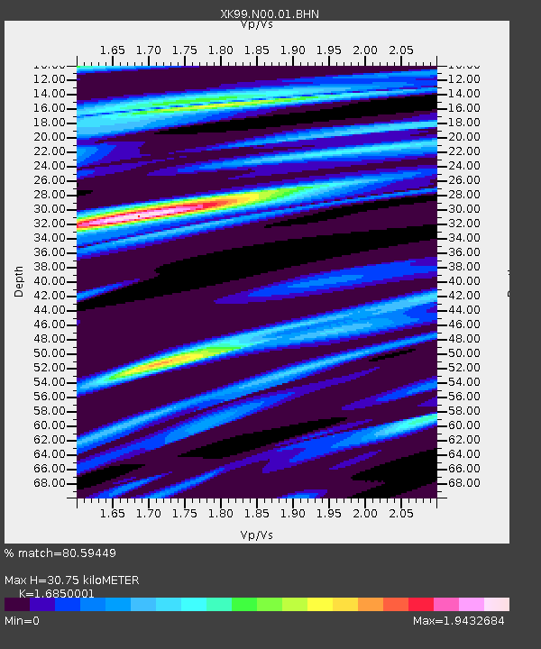
| Estimated Moho Depth: |
30.75 km |
| Estimated Crust Vp/Vs: |
1.69 |
| Assumed Crust Vp: |
6.178 km/s |
| Estimated Crust Vs: |
3.667 km/s |
| Estimated Crust Poisson's Ratio: |
0.23 |
|
| Radial Match: |
80.59449 % |
| Radial Bump: |
400 |
| Transverse Match: |
34.75348 % |
| Transverse Bump: |
400 |
| SOD ConfigId: |
16820 |
| Insert Time: |
2010-03-09 22:37:36.743 +0000 |
| GWidth: |
2.5 |
| Max Bumps: |
400 |
| Tol: |
0.001 |
|

Signal To Noise
| Channel | StoN | STA | LTA |
| XK:N00:01:BHN:20000120T01:12:10.006021Z | 0.54642415 | 2.540966E-7 | 4.6501714E-7 |
| XK:N00:01:BHE:20000120T01:12:10.006021Z | 1.2680091 | 6.0573996E-7 | 4.777095E-7 |
| XK:N00:01:BHZ:20000120T01:12:10.006021Z | 0.90626955 | 3.1291327E-7 | 3.4527616E-7 |
| Arrivals |
| Ps | 3.5 SECOND |
| PpPs | 13 SECOND |
| PsPs/PpSs | 17 SECOND |


