
Station XK N00 - North 00
Network: XK99 - CDROM (Colorado)
Nearby stations (2 deg radius)
| Station | Name | (Lat, Lon) | Start / End | Elevation |
| N00 | North 00 | (42.46, -107.70) | 1999-06-09 / 2000-12-31 | 1945 m |
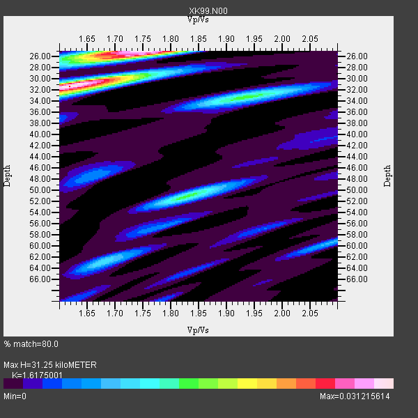
| Crust2 Type: | PH,orogen/46km, Orogen, 3.5 km seds. |
| Thickness Estimate: | 31 km |
| Thickness StdDev: | 6.8 km |
| Vp/Vs Estimate: | 1.62 |
| Vp/Vs StdDev: | 0.09 |
| Vs Estimate: | 3.82 km/s |
| Poisson's Ratio: | 0.19 |
| Peak Value: | 0.03 |
| Assumed Vp: | 6.178 km/s |
| Ps Weight: | 0.33333334 |
| PpPs Weight: | 0.33333334 |
| PsPs Weight: | 0.33333328 |
| Residual Complexity: | 0.760 |
| Nearby stations H: | +- |
| (2.0 deg) Vp/Vs: | +- |
2 with match > 90% ( 11.764706 %) and 17 with match > 80% ( 100.0 %) out of 17.
Download stack as xyz text file.
Azimuth Distribution of Events:

Prior Results for this Station
| Study | Thickness | Vp/Vs | Vp | Vs | Poissons Ratio | Extra |
| EARS | 31 km | 1.62 | 6.178 km/s | 3.82 km/s | 0.19 | |
| Crust2.0 | 46 km | 1.77 | 6.178 km/s | 3.498 km/s | 0.26 | PH,orogen/46km, Orogen, 3.5 km seds. |
| Global Maxima | 31 km | 1.62 | 6.178 km/s | 3.82 km/s | 0.19 | amp=0.031215614 |
| Local Maxima 1 | 25 km | 1.75 | 6.178 km/s | 3.525 km/s | 0.26 | amp=0.029135626 |
| Local Maxima 2 | 33 km | 1.93 | 6.178 km/s | 3.197 km/s | 0.32 | amp=0.014961278 |
| Local Maxima 3 | 51 km | 1.83 | 6.178 km/s | 3.381 km/s | 0.29 | amp=0.014856824 |
| Local Maxima 4 | 25 km | 1.70 | 6.178 km/s | 3.64 km/s | 0.23 | amp=0.00923111 |
| Predicted Arrivals for vertical incidence (zero ray parameter) | |
| Ps | 3.12 SECOND |
| PpPs | 13.24 SECOND |
| PsPs/PpSs | 16.36 SECOND |
Events Processed for this Station
Download zip of receiver functions as SAC
Plot maxima for each earthquake.
Events Used in the Stack
(17 events)| Radial Match | Distance | Baz | FERegion | Time | Lat/Lon | Depth | Magnitude |
| 93.67927 | 75.9 deg | 141.406 deg | Jujuy Province, Argentina | 2000/05/12 18:43:18 GMT | (-23.5, -66.5) | 225 km | 6.2 MB, 7.2 MW, 7.1 MW |
| 92.586365 | 87.9 deg | 298.573 deg | Volcano Islands, Japan Region | 2000/03/28 11:00:22 GMT | (22.3, 143.7) | 126 km | 6.8 MB, 7.6 MS, 7.6 MW, 7.6 MW |
| 89.76629 | 47.2 deg | 306.462 deg | Andreanof Islands, Aleutian Is. | 2000/04/21 04:35:17 GMT | (51.4, -178.1) | 33 km | 6.0 MB, 5.7 MS, 6.2 ML, 6.0 MW |
| 89.64232 | 88.7 deg | 30.85 deg | Turkey | 1999/08/17 00:01:39 GMT | (40.7, 29.9) | 17 km | 6.3 MB, 7.8 MS, 7.7 ME, 7.6 MW |
| 87.763664 | 85.0 deg | 241.827 deg | Tonga Islands | 2000/01/08 16:47:20 GMT | (-16.9, -174.2) | 183 km | 6.5 MB, 6.6 MS, 7.2 MW, 7.0 ME |
| 86.0897 | 88.8 deg | 292.604 deg | Mariana Islands Region | 2000/05/02 15:03:36 GMT | (17.4, 147.5) | 55 km | 5.8 MB, 5.9 MW, 5.9 MW |
| 84.76308 | 62.4 deg | 313.53 deg | Kuril Islands | 1999/08/06 00:32:41 GMT | (49.9, 156.3) | 58 km | 5.5 MB, 5.5 MS, 5.9 MW, 5.8 MW |
| 84.3341 | 31.4 deg | 142.151 deg | Honduras | 1999/07/11 14:14:16 GMT | (15.8, -88.3) | 10 km | 6.0 MB, 6.6 MS, 6.7 MW, 6.3 ME |
| 83.58182 | 63.2 deg | 313.168 deg | Kuril Islands | 1999/07/07 18:52:57 GMT | (49.2, 155.6) | 33 km | 6.0 MB, 5.6 MS, 6.1 MW, 5.8 ME |
| 82.07382 | 85.1 deg | 241.418 deg | Tonga Islands | 2000/01/26 13:26:50 GMT | (-17.3, -174.0) | 33 km | 5.9 MB, 6.0 MS, 6.4 MW, 6.3 MW |
| 81.65106 | 32.4 deg | 316.895 deg | Southern Alaska | 2000/05/19 20:34:26 GMT | (59.2, -153.1) | 80 km | 5.6 MB, 5.9 MW, 5.9 MW |
| 81.053795 | 51.3 deg | 139.979 deg | Ecuador | 1999/08/28 12:40:06 GMT | (-1.3, -77.5) | 196 km | 5.9 MB, 6.3 MW, 6.2 MW |
| 80.61944 | 32.9 deg | 313.31 deg | Kodiak Island Region, Alaska | 1999/12/07 00:19:49 GMT | (57.4, -154.5) | 41 km | 6.5 MB, 6.1 MS, 6.4 MW, 6.3 ML |
| 80.59449 | 94.6 deg | 235.665 deg | Kermadec Islands Region | 2000/01/20 00:59:23 GMT | (-28.2, -176.6) | 33 km | 5.4 MB, 5.5 MS, 5.7 MW, 5.7 MW |
| 80.39804 | 73.9 deg | 144.267 deg | Near Coast Of Northern Chile | 2000/01/08 11:59:21 GMT | (-23.2, -70.1) | 36 km | 5.8 MB, 5.9 MS, 6.4 MW, 6.1 ME |
| 80.26156 | 87.8 deg | 155.485 deg | Off Coast Of Southern Chile | 1999/08/22 09:35:39 GMT | (-40.5, -74.8) | 33 km | 6.2 MB, 5.8 MS, 6.4 MW, 6.2 MW |
| 80.16871 | 93.3 deg | 291.879 deg | Mariana Islands | 2000/02/26 08:11:48 GMT | (13.8, 144.8) | 132 km | 6.0 MB, 5.4 MS, 6.2 MW, 6.2 MW |
Losers
(0 events)| Radial Match | Distance | Baz | FERegion | Time | Lat/Lon | Depth | Magnitude | Reason |
