You are here: Home > Network List > XM99 - Rio Grande Seismic Transect Stations List
> Station TX02 Texas02 > Earthquake Result Viewer
TX02 Texas02 - Earthquake Result Viewer
| Earthquake location: |
Vanuatu Islands Region |
| Earthquake latitude/longitude: |
-19.5/173.8 |
| Earthquake time(UTC): |
2000/02/25 (056) 01:43:58 GMT |
| Earthquake Depth: |
33 km |
| Earthquake Magnitude: |
6.1 MB, 7.1 MS, 7.1 MW, 7.0 MW |
| Earthquake Catalog/Contributor: |
WHDF/NEIC |
|
| Network: |
XM Rio Grande Seismic Transect |
| Station: |
TX02 Texas02 |
| Lat/Lon: |
31.51 N/103.20 W |
| Elevation: |
765 m |
|
| Distance: |
94.3 deg |
| Az: |
58.214 deg |
| Baz: |
249.835 deg |
| Ray Param: |
0.041071337 |
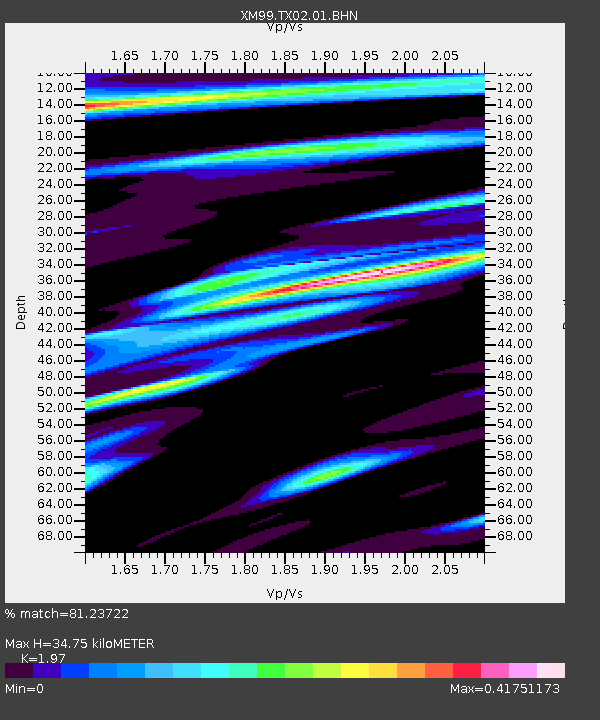
| Estimated Moho Depth: |
34.75 km |
| Estimated Crust Vp/Vs: |
1.97 |
| Assumed Crust Vp: |
6.121 km/s |
| Estimated Crust Vs: |
3.107 km/s |
| Estimated Crust Poisson's Ratio: |
0.33 |
|
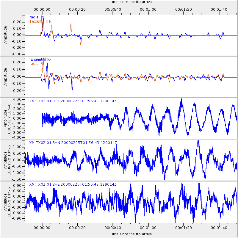
| Radial Match: |
81.23722 % |
| Radial Bump: |
400 |
| Transverse Match: |
82.519684 % |
| Transverse Bump: |
400 |
| SOD ConfigId: |
27569 |
| Insert Time: |
2010-02-26 17:34:55.695 +0000 |
| GWidth: |
2.5 |
| Max Bumps: |
400 |
| Tol: |
0.001 |
|
Signal To Noise
| Channel | StoN | STA | LTA |
| XM:TX02:01:BHN:20000225T01:56:43.129014Z | 0.6904835 | 2.469748E-7 | 3.5768386E-7 |
| XM:TX02:01:BHE:20000225T01:56:43.129014Z | 0.9542856 | 2.7321946E-7 | 2.8630785E-7 |
| XM:TX02:01:BHZ:20000225T01:56:43.129014Z | 0.91165954 | 5.5620916E-7 | 6.101062E-7 |
| Arrivals |
| Ps | 5.6 SECOND |
| PpPs | 17 SECOND |
| PsPs/PpSs | 22 SECOND |


