You are here: Home > Network List > XM99 - Rio Grande Seismic Transect Stations List
> Station TX02 Texas02 > Earthquake Result Viewer
TX02 Texas02 - Earthquake Result Viewer
| Earthquake location: |
Fiji Islands Region |
| Earthquake latitude/longitude: |
-14.5/-177.6 |
| Earthquake time(UTC): |
2000/01/17 (017) 21:18:04 GMT |
| Earthquake Depth: |
33 km |
| Earthquake Magnitude: |
5.6 MB, 5.7 MS, 5.9 MW, 5.8 MW |
| Earthquake Catalog/Contributor: |
WHDF/NEIC |
|
| Network: |
XM Rio Grande Seismic Transect |
| Station: |
TX02 Texas02 |
| Lat/Lon: |
31.51 N/103.20 W |
| Elevation: |
765 m |
|
| Distance: |
84.7 deg |
| Az: |
55.707 deg |
| Baz: |
249.529 deg |
| Ray Param: |
0.04527834 |
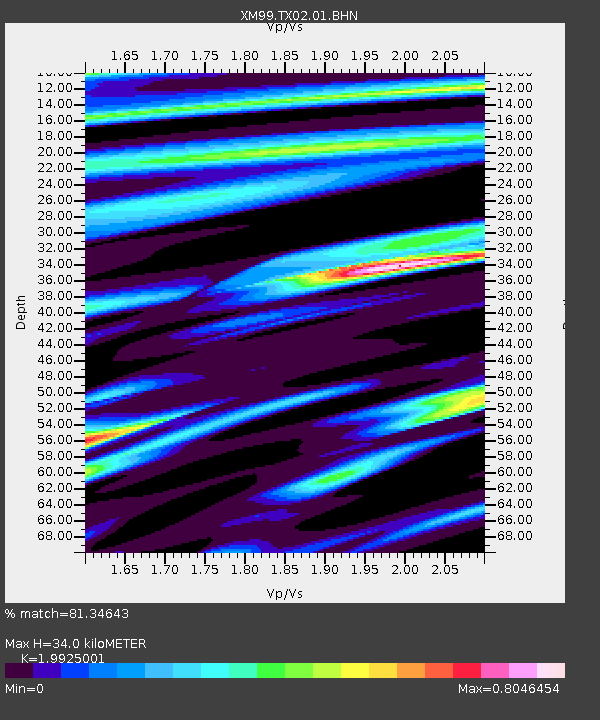
| Estimated Moho Depth: |
34.0 km |
| Estimated Crust Vp/Vs: |
1.99 |
| Assumed Crust Vp: |
6.121 km/s |
| Estimated Crust Vs: |
3.072 km/s |
| Estimated Crust Poisson's Ratio: |
0.33 |
|
| Radial Match: |
81.34643 % |
| Radial Bump: |
400 |
| Transverse Match: |
68.076225 % |
| Transverse Bump: |
400 |
| SOD ConfigId: |
27569 |
| Insert Time: |
2010-02-26 17:34:57.596 +0000 |
| GWidth: |
2.5 |
| Max Bumps: |
400 |
| Tol: |
0.001 |
|
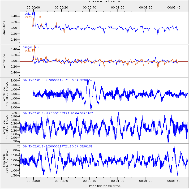
Signal To Noise
| Channel | StoN | STA | LTA |
| XM:TX02:01:BHN:20000117T21:30:04.089016Z | 0.84459645 | 2.9818648E-7 | 3.5305203E-7 |
| XM:TX02:01:BHE:20000117T21:30:04.089016Z | 1.3597463 | 4.1073966E-7 | 3.0207082E-7 |
| XM:TX02:01:BHZ:20000117T21:30:04.089016Z | 1.3453308 | 6.513569E-7 | 4.8416115E-7 |
| Arrivals |
| Ps | 5.6 SECOND |
| PpPs | 16 SECOND |
| PsPs/PpSs | 22 SECOND |


