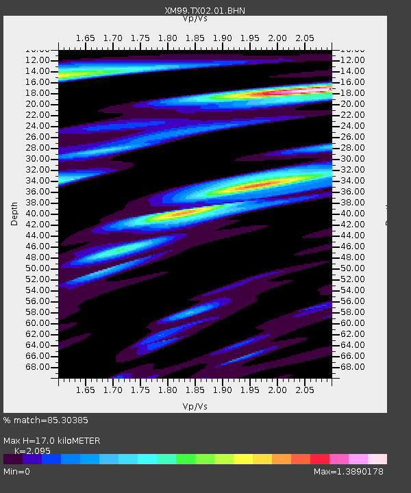
TX02 Texas02 - Earthquake Result Viewer
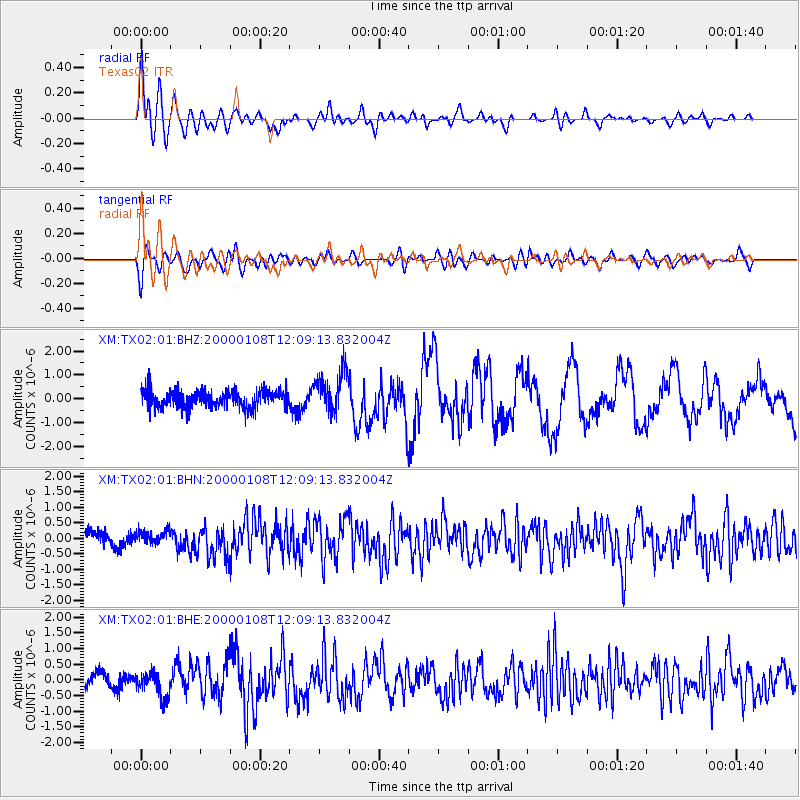
Earthquake location: Near Coast Of Northern Chile
Earthquake latitude/longitude: -23.2/-70.1
Earthquake time(UTC): 2000/01/08 (008) 11:59:21 GMT
Earthquake Depth: 36 km
Earthquake Magnitude: 5.8 MB, 5.9 MS, 6.4 MW, 6.1 ME
Earthquake Catalog/Contributor: WHDF/NEIC
Network: XM Rio Grande Seismic Transect
Station: TX02 Texas02
Lat/Lon: 31.51 N/103.20 W
Elevation: 765 m
Distance: 62.9 deg
Az: 328.43 deg
Baz: 145.657 deg
Ray Param: 0.05984469
Estimated Moho Depth: 17.0 km
Estimated Crust Vp/Vs: 2.10
Assumed Crust Vp: 6.121 km/s
Estimated Crust Vs: 2.921 km/s
Estimated Crust Poisson's Ratio: 0.35
Radial Match: 85.30385 %
Radial Bump: 400
Transverse Match: 72.80675 %
Transverse Bump: 400
SOD ConfigId: 27569
Insert Time: 2010-02-26 17:34:58.530 +0000
GWidth: 2.5
Max Bumps: 400
Tol: 0.001

Signal To Noise

ChannelStoNSTALTA
XM:TX02:01:BHN:20000108T12:09:13.832004Z0.84299852.1731374E-72.5778664E-7
XM:TX02:01:BHE:20000108T12:09:13.832004Z1.5561214.0095676E-72.5766425E-7
XM:TX02:01:BHZ:20000108T12:09:13.832004Z2.40123728.76332E-73.6495018E-7
Arrivals
Ps3.1 SECOND
PpPs8.3 SECOND
PsPs/PpSs11 SECOND