You are here: Home > Network List > XK99 - CDROM (Colorado) Stations List
> Station N04 North 04 > Earthquake Result Viewer
N04 North 04 - Earthquake Result Viewer
| Earthquake location: |
Tonga Islands |
| Earthquake latitude/longitude: |
-16.9/-174.2 |
| Earthquake time(UTC): |
2000/01/08 (008) 16:47:20 GMT |
| Earthquake Depth: |
183 km |
| Earthquake Magnitude: |
6.5 MB, 6.6 MS, 7.2 MW, 7.0 ME |
| Earthquake Catalog/Contributor: |
WHDF/NEIC |
|
| Network: |
XK CDROM (Colorado) |
| Station: |
N04 North 04 |
| Lat/Lon: |
41.98 N/107.43 W |
| Elevation: |
2002 m |
|
| Distance: |
84.9 deg |
| Az: |
43.476 deg |
| Baz: |
242.05 deg |
| Ray Param: |
0.044688333 |
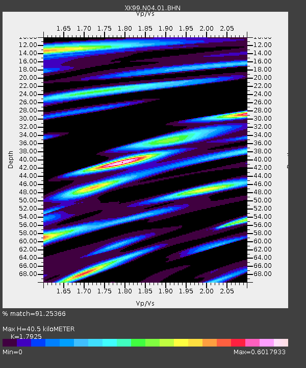
| Estimated Moho Depth: |
40.5 km |
| Estimated Crust Vp/Vs: |
1.79 |
| Assumed Crust Vp: |
6.159 km/s |
| Estimated Crust Vs: |
3.436 km/s |
| Estimated Crust Poisson's Ratio: |
0.27 |
|
| Radial Match: |
91.25366 % |
| Radial Bump: |
400 |
| Transverse Match: |
79.48096 % |
| Transverse Bump: |
400 |
| SOD ConfigId: |
287362 |
| Insert Time: |
2010-03-09 22:38:26.252 +0000 |
| GWidth: |
2.5 |
| Max Bumps: |
400 |
| Tol: |
0.001 |
|

Signal To Noise
| Channel | StoN | STA | LTA |
| XK:N04:01:BHN:20000108T16:59:03.803022Z | 2.623847 | 8.0007896E-7 | 3.0492592E-7 |
| XK:N04:01:BHE:20000108T16:59:03.803022Z | 2.8512814 | 1.3933242E-6 | 4.88666E-7 |
| XK:N04:01:BHZ:20000108T16:59:03.803022Z | 12.034832 | 5.6683493E-6 | 4.7099527E-7 |
| Arrivals |
| Ps | 5.3 SECOND |
| PpPs | 18 SECOND |
| PsPs/PpSs | 23 SECOND |


