
Station XK N04 - North 04
Network: XK99 - CDROM (Colorado)
Nearby stations (2 deg radius)
| Station | Name | (Lat, Lon) | Start / End | Elevation |
| N04 | North 04 | (41.98, -107.43) | 1999-06-06 / 2000-12-31 | 2002 m |
| Crust2 Type: | P1,orogen/46km, Urals, Tethian Orogen, 2 km seds. |
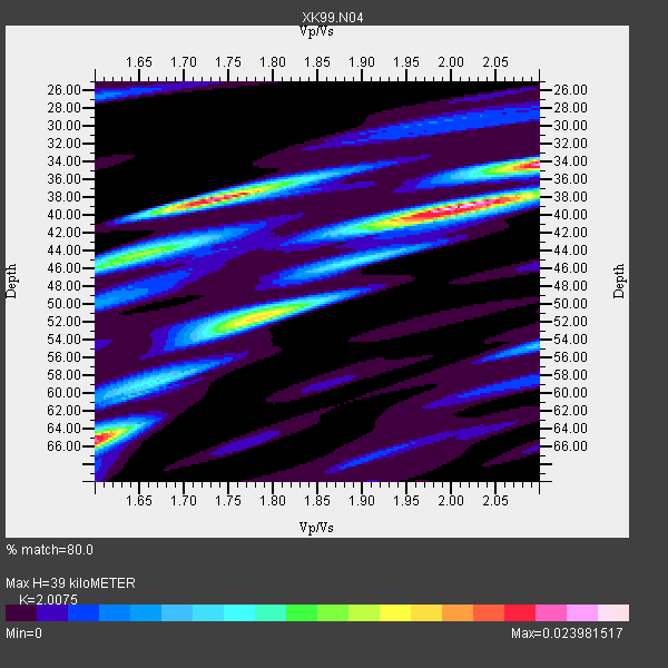
| Thickness Estimate: | 39 km |
| Thickness StdDev: | 9.5 km |
| Vp/Vs Estimate: | 2.01 |
| Vp/Vs StdDev: | 0.17 |
| Vs Estimate: | 3.068 km/s |
| Poisson's Ratio: | 0.33 |
| Peak Value: | 0.02 |
| Assumed Vp: | 6.159 km/s |
| Ps Weight: | 0.33333334 |
| PpPs Weight: | 0.33333334 |
| PsPs Weight: | 0.33333328 |
| Residual Complexity: | 0.705 |
| Nearby stations H: | +- |
| (2.0 deg) Vp/Vs: | +- |
4 with match > 90% ( 57.142857 %) and 7 with match > 80% ( 100.0 %) out of 7.
Download stack as xyz text file.
Azimuth Distribution of Events:

Prior Results for this Station
| Study | Thickness | Vp/Vs | Vp | Vs | Poissons Ratio | Extra |
| EARS | 39 km | 2.01 | 6.159 km/s | 3.068 km/s | 0.33 | |
| Crust2.0 | 46 km | 1.76 | 6.159 km/s | 3.507 km/s | 0.26 | P1,orogen/46km, Urals, Tethian Orogen, 2 km seds. |
| Global Maxima | 39 km | 2.01 | 6.159 km/s | 3.068 km/s | 0.33 | amp=0.023981517 |
| Local Maxima 1 | 38 km | 1.74 | 6.159 km/s | 3.545 km/s | 0.25 | amp=0.021075241 |
| Local Maxima 2 | 65 km | 1.60 | 6.159 km/s | 3.843 km/s | 0.18 | amp=0.016460992 |
| Local Maxima 3 | 34 km | 2.10 | 6.159 km/s | 2.936 km/s | 0.35 | amp=0.0155355865 |
| Local Maxima 4 | 52 km | 1.78 | 6.159 km/s | 3.46 km/s | 0.27 | amp=0.014912658 |
| Predicted Arrivals for vertical incidence (zero ray parameter) | |
| Ps | 6.38 SECOND |
| PpPs | 19.05 SECOND |
| PsPs/PpSs | 25.43 SECOND |
Events Processed for this Station
Download zip of receiver functions as SAC
Plot maxima for each earthquake.
Events Used in the Stack
(7 events)| Radial Match | Distance | Baz | FERegion | Time | Lat/Lon | Depth | Magnitude |
| 96.35347 | 88.3 deg | 298.761 deg | Volcano Islands, Japan Region | 2000/03/28 11:00:22 GMT | (22.3, 143.7) | 126 km | 6.8 MB, 7.6 MS, 7.6 MW, 7.6 MW |
| 94.290215 | 33.4 deg | 313.907 deg | Kodiak Island Region, Alaska | 1999/12/06 23:12:33 GMT | (57.4, -154.5) | 66 km | 6.8 MB, 7.0 MW, 7.0 ML |
| 92.132965 | 47.6 deg | 306.885 deg | Andreanof Islands, Aleutian Is. | 2000/04/21 04:35:17 GMT | (51.4, -178.1) | 33 km | 6.0 MB, 5.7 MS, 6.2 ML, 6.0 MW |
| 91.25366 | 84.9 deg | 242.05 deg | Tonga Islands | 2000/01/08 16:47:20 GMT | (-16.9, -174.2) | 183 km | 6.5 MB, 6.6 MS, 7.2 MW, 7.0 ME |
| 88.96638 | 33.4 deg | 313.812 deg | Kodiak Island Region, Alaska | 1999/12/07 00:19:49 GMT | (57.4, -154.5) | 41 km | 6.5 MB, 6.1 MS, 6.4 MW, 6.3 ML |
| 86.008644 | 96.7 deg | 254.079 deg | Vanuatu Islands | 1999/11/26 13:21:15 GMT | (-16.4, 168.2) | 33 km | 6.4 MB, 7.3 MS, 7.5 MW, 7.3 MW |
| 81.000374 | 94.0 deg | 248.339 deg | Fiji Islands Region | 2000/01/09 21:54:40 GMT | (-18.8, 174.4) | 33 km | 5.6 MB, 6.4 MS, 6.4 MW, 6.3 MW |
Losers
(0 events)| Radial Match | Distance | Baz | FERegion | Time | Lat/Lon | Depth | Magnitude | Reason |
