You are here: Home > Network List > XK99 - CDROM (Colorado) Stations List
> Station N08 North 08 > Earthquake Result Viewer
N08 North 08 - Earthquake Result Viewer
| Earthquake location: |
Kuril Islands |
| Earthquake latitude/longitude: |
49.9/156.3 |
| Earthquake time(UTC): |
1999/08/06 (218) 00:32:41 GMT |
| Earthquake Depth: |
58 km |
| Earthquake Magnitude: |
5.5 MB, 5.5 MS, 5.9 MW, 5.8 MW |
| Earthquake Catalog/Contributor: |
WHDF/NEIC |
|
| Network: |
XK CDROM (Colorado) |
| Station: |
N08 North 08 |
| Lat/Lon: |
41.62 N/107.28 W |
| Elevation: |
2150 m |
|
| Distance: |
63.2 deg |
| Az: |
56.558 deg |
| Baz: |
314.009 deg |
| Ray Param: |
0.059582848 |
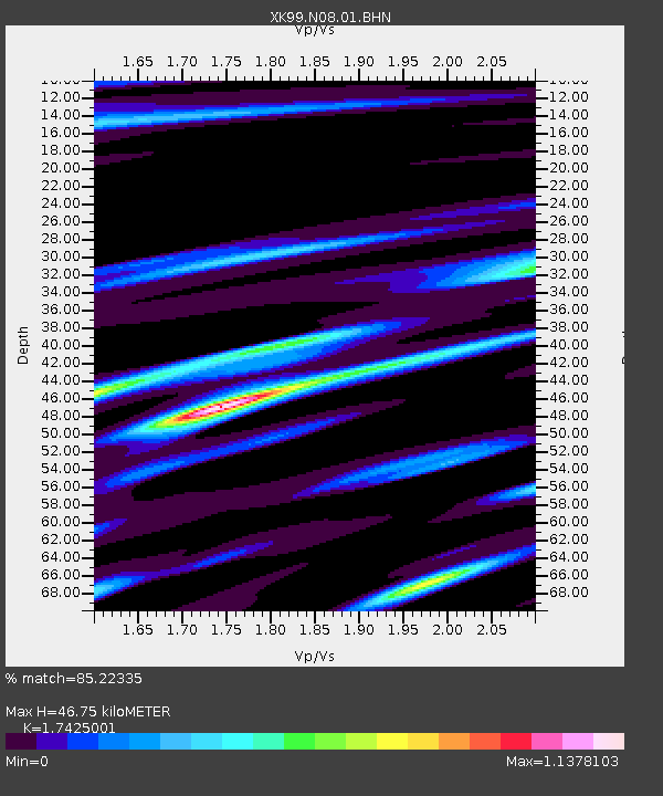
| Estimated Moho Depth: |
46.75 km |
| Estimated Crust Vp/Vs: |
1.74 |
| Assumed Crust Vp: |
6.159 km/s |
| Estimated Crust Vs: |
3.534 km/s |
| Estimated Crust Poisson's Ratio: |
0.25 |
|
| Radial Match: |
85.22335 % |
| Radial Bump: |
333 |
| Transverse Match: |
71.05961 % |
| Transverse Bump: |
392 |
| SOD ConfigId: |
287362 |
| Insert Time: |
2010-03-09 22:39:18.600 +0000 |
| GWidth: |
2.5 |
| Max Bumps: |
400 |
| Tol: |
0.001 |
|

Signal To Noise
| Channel | StoN | STA | LTA |
| XK:N08:01:BHN:19990806T00:42:33.310027Z | 0.9733063 | 1.0515803E-7 | 1.0804207E-7 |
| XK:N08:01:BHE:19990806T00:42:33.310027Z | 1.0856029 | 1.5008273E-7 | 1.3824828E-7 |
| XK:N08:01:BHZ:19990806T00:42:33.310027Z | 4.077301 | 3.8643196E-7 | 9.477641E-8 |
| Arrivals |
| Ps | 5.9 SECOND |
| PpPs | 20 SECOND |
| PsPs/PpSs | 26 SECOND |


