
Station XK N08 - North 08
Network: XK99 - CDROM (Colorado)
Nearby stations (2 deg radius)
| Station | Name | (Lat, Lon) | Start / End | Elevation |
| N08 | North 08 | (41.62, -107.28) | 1999-06-07 / 2000-12-31 | 2150 m |
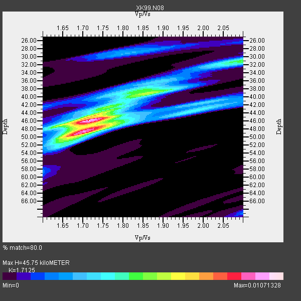
| Crust2 Type: | P1,orogen/46km, Urals, Tethian Orogen, 2 km seds. |
| Thickness Estimate: | 46 km |
| Thickness StdDev: | 4.1 km |
| Vp/Vs Estimate: | 1.71 |
| Vp/Vs StdDev: | 0.08 |
| Vs Estimate: | 3.596 km/s |
| Poisson's Ratio: | 0.24 |
| Peak Value: | 0.01 |
| Assumed Vp: | 6.159 km/s |
| Ps Weight: | 0.33333334 |
| PpPs Weight: | 0.33333334 |
| PsPs Weight: | 0.33333328 |
| Residual Complexity: | 0.640 |
| Nearby stations H: | +- |
| (2.0 deg) Vp/Vs: | +- |
5 with match > 90% ( 35.714287 %) and 14 with match > 80% ( 100.0 %) out of 14.
Download stack as xyz text file.
Azimuth Distribution of Events:

Prior Results for this Station
| Study | Thickness | Vp/Vs | Vp | Vs | Poissons Ratio | Extra |
| EARS | 46 km | 1.71 | 6.159 km/s | 3.596 km/s | 0.24 | |
| Crust2.0 | 46 km | 1.76 | 6.159 km/s | 3.507 km/s | 0.26 | P1,orogen/46km, Urals, Tethian Orogen, 2 km seds. |
| Global Maxima | 46 km | 1.71 | 6.159 km/s | 3.596 km/s | 0.24 | amp=0.01071328 |
| Local Maxima 1 | 48 km | 1.72 | 6.159 km/s | 3.591 km/s | 0.24 | amp=0.007839193 |
| Local Maxima 2 | 31 km | 2.10 | 6.159 km/s | 2.936 km/s | 0.35 | amp=0.00490302 |
| Local Maxima 3 | 38 km | 1.88 | 6.159 km/s | 3.28 km/s | 0.30 | amp=0.0037869718 |
| Local Maxima 4 | 43 km | 1.99 | 6.159 km/s | 3.091 km/s | 0.33 | amp=0.0036099367 |
| Predicted Arrivals for vertical incidence (zero ray parameter) | |
| Ps | 5.29 SECOND |
| PpPs | 20.15 SECOND |
| PsPs/PpSs | 25.44 SECOND |
Events Processed for this Station
Download zip of receiver functions as SAC
Plot maxima for each earthquake.
Events Used in the Stack
(14 events)| Radial Match | Distance | Baz | FERegion | Time | Lat/Lon | Depth | Magnitude |
| 97.38202 | 88.6 deg | 298.871 deg | Volcano Islands, Japan Region | 2000/03/28 11:00:22 GMT | (22.3, 143.7) | 126 km | 6.8 MB, 7.6 MS, 7.6 MW, 7.6 MW |
| 94.8542 | 75.1 deg | 141.615 deg | Jujuy Province, Argentina | 2000/05/12 18:43:18 GMT | (-23.5, -66.5) | 225 km | 6.2 MB, 7.2 MW, 7.1 MW |
| 94.41644 | 33.7 deg | 314.276 deg | Kodiak Island Region, Alaska | 1999/12/06 23:12:33 GMT | (57.4, -154.5) | 66 km | 6.8 MB, 7.0 MW, 7.0 ML |
| 92.99276 | 33.7 deg | 314.182 deg | Kodiak Island Region, Alaska | 1999/12/07 00:19:49 GMT | (57.4, -154.5) | 41 km | 6.5 MB, 6.1 MS, 6.4 MW, 6.3 ML |
| 91.95644 | 84.9 deg | 242.186 deg | Tonga Islands | 2000/01/08 16:47:20 GMT | (-16.9, -174.2) | 183 km | 6.5 MB, 6.6 MS, 7.2 MW, 7.0 ME |
| 89.68714 | 80.7 deg | 141.403 deg | Santiago Del Estero Prov., Arg. | 2000/04/23 09:27:23 GMT | (-28.3, -63.0) | 608 km | 6.6 MB, 7.0 MW, 7.0 MW |
| 86.63965 | 94.8 deg | 248.251 deg | Vanuatu Islands Region | 2000/02/25 01:43:58 GMT | (-19.5, 173.8) | 33 km | 6.1 MB, 7.1 MS, 7.1 MW, 7.0 MW |
| 86.31192 | 33.3 deg | 317.698 deg | Southern Alaska | 2000/05/19 20:34:26 GMT | (59.2, -153.1) | 80 km | 5.6 MB, 5.9 MW, 5.9 MW |
| 85.22335 | 63.2 deg | 314.009 deg | Kuril Islands | 1999/08/06 00:32:41 GMT | (49.9, 156.3) | 58 km | 5.5 MB, 5.5 MS, 5.9 MW, 5.8 MW |
| 83.87893 | 30.5 deg | 141.985 deg | Honduras | 1999/07/11 14:14:16 GMT | (15.8, -88.3) | 10 km | 6.0 MB, 6.6 MS, 6.7 MW, 6.3 ME |
| 82.60064 | 55.8 deg | 316.108 deg | Komandorskiye Ostrova Region | 1999/11/26 00:29:00 GMT | (55.1, 165.4) | 33 km | 5.6 MB, 5.8 MS |
| 82.14498 | 47.9 deg | 307.183 deg | Andreanof Islands, Aleutian Is. | 2000/04/21 04:35:17 GMT | (51.4, -178.1) | 33 km | 6.0 MB, 5.7 MS, 6.2 ML, 6.0 MW |
| 81.698235 | 95.4 deg | 236.247 deg | Kermadec Islands Region | 1999/07/19 02:17:03 GMT | (-28.6, -177.6) | 39 km | 6.3 MB, 6.2 MS, 6.4 MW, 6.3 ME |
| 80.80705 | 64.0 deg | 313.643 deg | Kuril Islands | 1999/07/07 18:52:57 GMT | (49.2, 155.6) | 33 km | 6.0 MB, 5.6 MS, 6.1 MW, 5.8 ME |
Losers
(0 events)| Radial Match | Distance | Baz | FERegion | Time | Lat/Lon | Depth | Magnitude | Reason |
