You are here: Home > Network List > XK99 - CDROM (Colorado) Stations List
> Station N08 North 08 > Earthquake Result Viewer
N08 North 08 - Earthquake Result Viewer
| Earthquake location: |
Kermadec Islands Region |
| Earthquake latitude/longitude: |
-28.6/-177.6 |
| Earthquake time(UTC): |
1999/07/19 (200) 02:17:03 GMT |
| Earthquake Depth: |
39 km |
| Earthquake Magnitude: |
6.3 MB, 6.2 MS, 6.4 MW, 6.3 ME |
| Earthquake Catalog/Contributor: |
WHDF/NEIC |
|
| Network: |
XK CDROM (Colorado) |
| Station: |
N08 North 08 |
| Lat/Lon: |
41.62 N/107.28 W |
| Elevation: |
2150 m |
|
| Distance: |
95.4 deg |
| Az: |
45.162 deg |
| Baz: |
236.247 deg |
| Ray Param: |
0.04078156 |
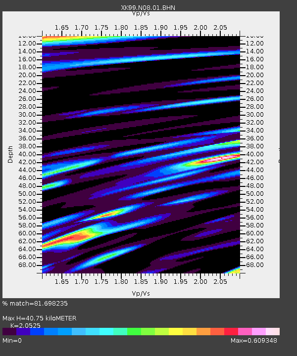
| Estimated Moho Depth: |
40.75 km |
| Estimated Crust Vp/Vs: |
2.05 |
| Assumed Crust Vp: |
6.159 km/s |
| Estimated Crust Vs: |
3.001 km/s |
| Estimated Crust Poisson's Ratio: |
0.34 |
|
| Radial Match: |
81.698235 % |
| Radial Bump: |
400 |
| Transverse Match: |
75.45372 % |
| Transverse Bump: |
400 |
| SOD ConfigId: |
287362 |
| Insert Time: |
2010-03-09 22:39:19.863 +0000 |
| GWidth: |
2.5 |
| Max Bumps: |
400 |
| Tol: |
0.001 |
|

Signal To Noise
| Channel | StoN | STA | LTA |
| XK:N08:01:BHN:19990719T02:29:52.459011Z | 2.1677823 | 1.0571271E-7 | 4.876537E-8 |
| XK:N08:01:BHE:19990719T02:29:52.459011Z | 3.9181113 | 2.446132E-7 | 6.2431404E-8 |
| XK:N08:01:BHZ:19990719T02:29:52.459011Z | 11.487064 | 7.708002E-7 | 6.710158E-8 |
| Arrivals |
| Ps | 7.1 SECOND |
| PpPs | 20 SECOND |
| PsPs/PpSs | 27 SECOND |


