You are here: Home > Network List > XK99 - CDROM (Colorado) Stations List
> Station N08 North 08 > Earthquake Result Viewer
N08 North 08 - Earthquake Result Viewer
| Earthquake location: |
Komandorskiye Ostrova Region |
| Earthquake latitude/longitude: |
55.1/165.4 |
| Earthquake time(UTC): |
1999/11/26 (330) 00:29:00 GMT |
| Earthquake Depth: |
33 km |
| Earthquake Magnitude: |
5.6 MB, 5.8 MS |
| Earthquake Catalog/Contributor: |
WHDF/NEIC |
|
| Network: |
XK CDROM (Colorado) |
| Station: |
N08 North 08 |
| Lat/Lon: |
41.62 N/107.28 W |
| Elevation: |
2150 m |
|
| Distance: |
55.8 deg |
| Az: |
64.845 deg |
| Baz: |
316.108 deg |
| Ray Param: |
0.064476214 |
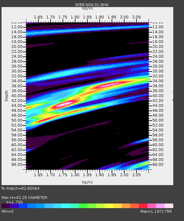
| Estimated Moho Depth: |
43.25 km |
| Estimated Crust Vp/Vs: |
1.75 |
| Assumed Crust Vp: |
6.159 km/s |
| Estimated Crust Vs: |
3.509 km/s |
| Estimated Crust Poisson's Ratio: |
0.26 |
|
| Radial Match: |
82.60064 % |
| Radial Bump: |
400 |
| Transverse Match: |
70.63482 % |
| Transverse Bump: |
400 |
| SOD ConfigId: |
287362 |
| Insert Time: |
2010-03-09 22:39:28.695 +0000 |
| GWidth: |
2.5 |
| Max Bumps: |
400 |
| Tol: |
0.001 |
|

Signal To Noise
| Channel | StoN | STA | LTA |
| XK:N08:01:BHN:19991126T00:38:03.702007Z | 0.8717015 | 1.7760323E-7 | 2.0374318E-7 |
| XK:N08:01:BHE:19991126T00:38:03.702007Z | 1.7047019 | 3.9347606E-7 | 2.3081809E-7 |
| XK:N08:01:BHZ:19991126T00:38:03.702007Z | 2.1206934 | 3.6334495E-7 | 1.713331E-7 |
| Arrivals |
| Ps | 5.6 SECOND |
| PpPs | 18 SECOND |
| PsPs/PpSs | 24 SECOND |


