You are here: Home > Network List > XM99 - Rio Grande Seismic Transect Stations List
> Station TX05 Texas05 > Earthquake Result Viewer
TX05 Texas05 - Earthquake Result Viewer

| Earthquake location: |
Sea Of Japan |
| Earthquake latitude/longitude: |
36.8/135.5 |
| Earthquake time(UTC): |
2000/06/06 (158) 21:16:42 GMT |
| Earthquake Depth: |
10 km |
| Earthquake Magnitude: |
5.7 MB, 5.3 MS, 5.9 MW, 5.8 MW |
| Earthquake Catalog/Contributor: |
WHDF/NEIC |
|
| Network: |
XM Rio Grande Seismic Transect |
| Station: |
TX05 Texas05 |
| Lat/Lon: |
31.88 N/103.61 W |
| Elevation: |
873 m |
|
| Distance: |
92.1 deg |
| Az: |
46.911 deg |
| Baz: |
316.469 deg |
| Ray Param: |
0.04150493 |
| Estimated Moho Depth: |
10.0 km |
| Estimated Crust Vp/Vs: |
1.60 |
| Assumed Crust Vp: |
6.121 km/s |
| Estimated Crust Vs: |
3.825 km/s |
| Estimated Crust Poisson's Ratio: |
0.18 |
|
| Radial Match: |
99.97725 % |
| Radial Bump: |
5 |
| Transverse Match: |
99.93219 % |
| Transverse Bump: |
8 |
| SOD ConfigId: |
16820 |
| Insert Time: |
2010-02-26 17:35:05.112 +0000 |
| GWidth: |
2.5 |
| Max Bumps: |
400 |
| Tol: |
0.001 |
|
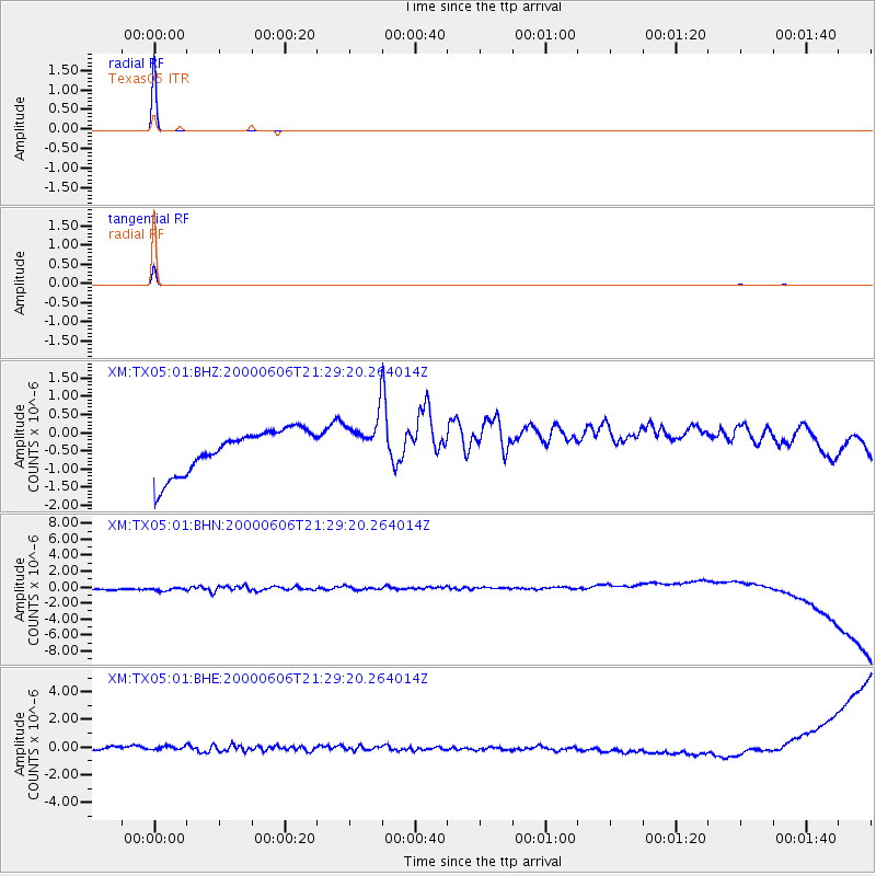
Signal To Noise
| Channel | StoN | STA | LTA |
| XM:TX05:01:BHN:20000606T21:29:20.264014Z | 1.0391575 | 7.764241E-7 | 7.471669E-7 |
| XM:TX05:01:BHE:20000606T21:29:20.264014Z | 0.9766699 | 3.9522502E-7 | 4.0466588E-7 |
| XM:TX05:01:BHZ:20000606T21:29:20.264014Z | 1.1208938 | 6.6420256E-7 | 5.9256513E-7 |
| Arrivals |
| Ps | 1.0 SECOND |
| PpPs | 4.2 SECOND |
| PsPs/PpSs | 5.2 SECOND |


