
Station XM TX05 - Texas05
Network: XM99 - Rio Grande Seismic Transect
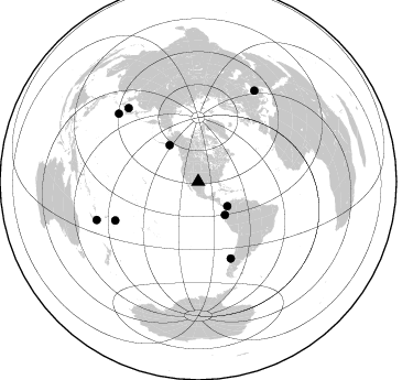
Nearby stations (2 deg radius)
| Station | Name | (Lat, Lon) | Start / End | Elevation |
| TX05 | Texas05 | (31.88, -103.61) | 1999-09-11 / 2001-12-31 | 873 m |
| Crust2 Type: | Q1,orogen/39km no ice, Appalachians, North Andes |
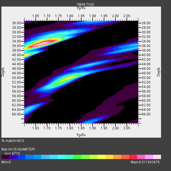
| Thickness Estimate: | 35 km |
| Thickness StdDev: | 2.5 km |
| Vp/Vs Estimate: | 1.68 |
| Vp/Vs StdDev: | 0.04 |
| Vs Estimate: | 3.649 km/s |
| Poisson's Ratio: | 0.22 |
| Peak Value: | 0.01 |
| Assumed Vp: | 6.121 km/s |
| Ps Weight: | 0.33333334 |
| PpPs Weight: | 0.33333334 |
| PsPs Weight: | 0.33333328 |
| Residual Complexity: | 0.661 |
| Nearby stations H: | +- |
| (2.0 deg) Vp/Vs: | +- |
5 with match > 90% ( 50.0 %) and 9 with match > 80% ( 90.0 %) out of 10.
Download stack as xyz text file.
Azimuth Distribution of Events:
Prior Results for this Station
| Study | Thickness | Vp/Vs | Vp | Vs | Poissons Ratio | Extra |
| EARS | 35 km | 1.68 | 6.121 km/s | 3.649 km/s | 0.22 | |
| Crust2.0 | 39 km | 1.76 | 6.121 km/s | 3.485 km/s | 0.26 | Q1,orogen/39km no ice, Appalachians, North Andes |
| Wilson | 44 km | 1.75 | 6.27 km/s | 3.583 km/s | 0.26 | |
| Global Maxima | 35 km | 1.68 | 6.121 km/s | 3.649 km/s | 0.22 | amp=0.011943476 |
| Local Maxima 1 | 50 km | 1.79 | 6.121 km/s | 3.419 km/s | 0.27 | amp=0.0074378643 |
| Local Maxima 2 | 33 km | 1.71 | 6.121 km/s | 3.584 km/s | 0.24 | amp=0.0057665166 |
| Local Maxima 3 | 53 km | 1.73 | 6.121 km/s | 3.533 km/s | 0.25 | amp=0.0044725295 |
| Local Maxima 4 | 40 km | 1.60 | 6.121 km/s | 3.819 km/s | 0.18 | amp=0.004439534 |
| Predicted Arrivals for vertical incidence (zero ray parameter) | |
| Ps | 3.87 SECOND |
| PpPs | 15.31 SECOND |
| PsPs/PpSs | 19.19 SECOND |
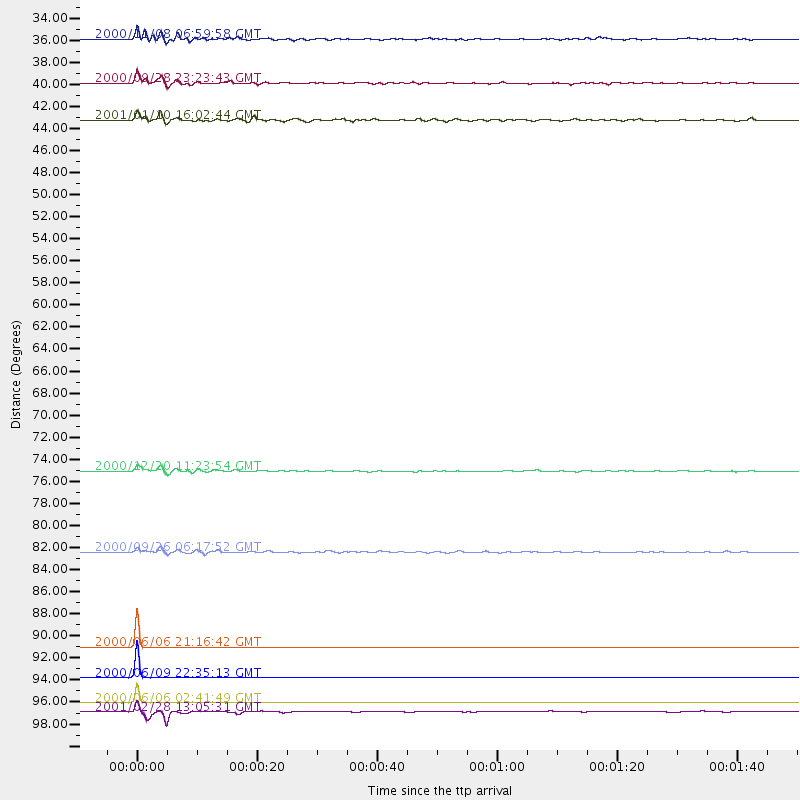
Events Processed for this Station
Download zip of receiver functions as SAC
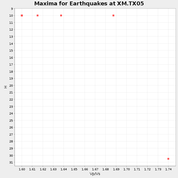
Plot maxima for each earthquake.
Events Used in the Stack
(9 events)| Radial Match | Distance | Baz | FERegion | Time | Lat/Lon | Depth | Magnitude |
| 99.98009 | 97.4 deg | 31.791 deg | Turkey | 2000/06/06 02:41:49 GMT | (40.7, 33.0) | 10 km | 5.5 MB, 6.1 MS, 6.1 MW, 6.0 MW |
| 99.97725 | 92.1 deg | 316.469 deg | Sea Of Japan | 2000/06/06 21:16:42 GMT | (36.8, 135.5) | 10 km | 5.7 MB, 5.3 MS, 5.9 MW, 5.8 MW |
| 99.89527 | 95.0 deg | 310.523 deg | Southeast Of Honshu, Japan | 2000/06/09 22:35:13 GMT | (30.5, 137.7) | 473 km | 5.4 MB, 5.9 MW, 5.8 MW |
| 96.50436 | 98.3 deg | 249.378 deg | Southeast Of Loyalty Islands | 2001/02/28 13:05:31 GMT | (-22.0, 170.1) | 10 km | 5.8 MB, 6.1 MS, 6.2 MW |
| 92.51245 | 38.6 deg | 141.222 deg | Near Coast Of Ecuador | 2000/09/28 23:23:43 GMT | (-0.2, -80.6) | 23 km | 5.8 MB, 6.0 MS, 6.6 MW, 6.4 MW |
| 87.64106 | 83.1 deg | 245.042 deg | Tonga Islands | 2000/09/26 06:17:52 GMT | (-17.2, -173.9) | 56 km | 6.1 MB, 6.1 MS, 6.4 MW, 6.1 ME |
| 84.72845 | 34.5 deg | 130.304 deg | Panama-Colombia Border Region | 2000/11/08 06:59:58 GMT | (7.0, -77.8) | 17 km | 6.0 MB, 6.4 MS, 6.5 MW, 6.2 ML |
| 82.616974 | 42.2 deg | 321.707 deg | Kodiak Island Region, Alaska | 2001/01/10 16:02:44 GMT | (57.1, -153.2) | 33 km | 6.2 MB, 6.8 MS, 7.1 MW, 6.8 ML |
| 81.52364 | 75.5 deg | 157.077 deg | Off Coast Of Central Chile | 2000/12/20 11:23:54 GMT | (-39.0, -74.7) | 11 km | 6.1 MB, 6.2 MS, 6.4 MW, 6.0 ME |
Losers
(1 events)| Radial Match | Distance | Baz | FERegion | Time | Lat/Lon | Depth | Magnitude | Reason |
| 85.5554 | 86.0 deg | 246.006 deg | Fiji Islands Region | 2001/04/28 04:49:53 GMT | (-18.1, -176.9) | 352 km | 6.2 MB, 6.8 MW, 6.8 MW |
