You are here: Home > Network List > XM99 - Rio Grande Seismic Transect Stations List
> Station TX05 Texas05 > Earthquake Result Viewer
TX05 Texas05 - Earthquake Result Viewer
| Earthquake location: |
Near Coast Of Ecuador |
| Earthquake latitude/longitude: |
-0.2/-80.6 |
| Earthquake time(UTC): |
2000/09/28 (272) 23:23:43 GMT |
| Earthquake Depth: |
23 km |
| Earthquake Magnitude: |
5.8 MB, 6.0 MS, 6.6 MW, 6.4 MW |
| Earthquake Catalog/Contributor: |
WHDF/NEIC |
|
| Network: |
XM Rio Grande Seismic Transect |
| Station: |
TX05 Texas05 |
| Lat/Lon: |
31.88 N/103.61 W |
| Elevation: |
873 m |
|
| Distance: |
38.6 deg |
| Az: |
327.803 deg |
| Baz: |
141.222 deg |
| Ray Param: |
0.07540743 |
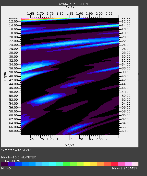
| Estimated Moho Depth: |
10.0 km |
| Estimated Crust Vp/Vs: |
1.69 |
| Assumed Crust Vp: |
6.121 km/s |
| Estimated Crust Vs: |
3.627 km/s |
| Estimated Crust Poisson's Ratio: |
0.23 |
|
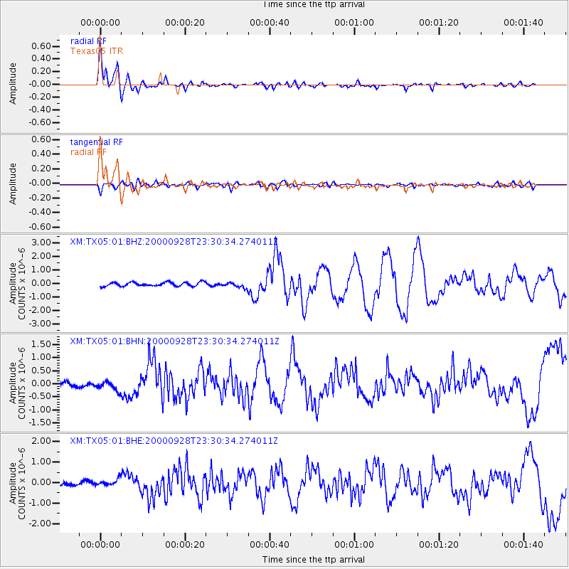
| Radial Match: |
92.51245 % |
| Radial Bump: |
400 |
| Transverse Match: |
74.1672 % |
| Transverse Bump: |
400 |
| SOD ConfigId: |
3744 |
| Insert Time: |
2010-02-26 17:35:07.576 +0000 |
| GWidth: |
2.5 |
| Max Bumps: |
400 |
| Tol: |
0.001 |
|
Signal To Noise
| Channel | StoN | STA | LTA |
| XM:TX05:01:BHN:20000928T23:30:34.274011Z | 1.2155259 | 1.7804462E-7 | 1.4647539E-7 |
| XM:TX05:01:BHE:20000928T23:30:34.274011Z | 1.636995 | 1.7234902E-7 | 1.0528378E-7 |
| XM:TX05:01:BHZ:20000928T23:30:34.274011Z | 1.3828762 | 1.9793777E-7 | 1.4313484E-7 |
| Arrivals |
| Ps | 1.2 SECOND |
| PpPs | 4.1 SECOND |
| PsPs/PpSs | 5.3 SECOND |


