You are here: Home > Network List > XM99 - Rio Grande Seismic Transect Stations List
> Station TX05 Texas05 > Earthquake Result Viewer
TX05 Texas05 - Earthquake Result Viewer
| Earthquake location: |
Tonga Islands |
| Earthquake latitude/longitude: |
-17.2/-173.9 |
| Earthquake time(UTC): |
2000/09/26 (270) 06:17:52 GMT |
| Earthquake Depth: |
56 km |
| Earthquake Magnitude: |
6.1 MB, 6.1 MS, 6.4 MW, 6.1 ME |
| Earthquake Catalog/Contributor: |
WHDF/NEIC |
|
| Network: |
XM Rio Grande Seismic Transect |
| Station: |
TX05 Texas05 |
| Lat/Lon: |
31.88 N/103.61 W |
| Elevation: |
873 m |
|
| Distance: |
83.1 deg |
| Az: |
53.79 deg |
| Baz: |
245.042 deg |
| Ray Param: |
0.046304587 |
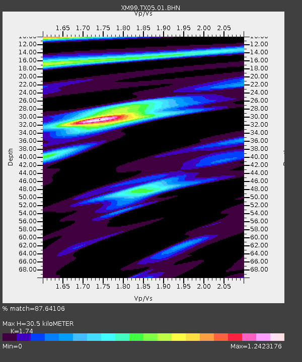
| Estimated Moho Depth: |
30.5 km |
| Estimated Crust Vp/Vs: |
1.74 |
| Assumed Crust Vp: |
6.121 km/s |
| Estimated Crust Vs: |
3.518 km/s |
| Estimated Crust Poisson's Ratio: |
0.25 |
|
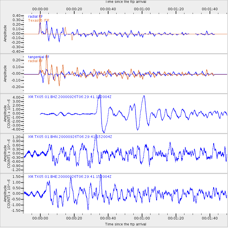
| Radial Match: |
87.64106 % |
| Radial Bump: |
400 |
| Transverse Match: |
87.71003 % |
| Transverse Bump: |
400 |
| SOD ConfigId: |
16820 |
| Insert Time: |
2010-02-26 17:35:10.429 +0000 |
| GWidth: |
2.5 |
| Max Bumps: |
400 |
| Tol: |
0.001 |
|
Signal To Noise
| Channel | StoN | STA | LTA |
| XM:TX05:01:BHN:20000926T06:29:41.152004Z | 0.95377374 | 1.1206118E-7 | 1.1749241E-7 |
| XM:TX05:01:BHE:20000926T06:29:41.152004Z | 3.646601 | 4.559026E-7 | 1.2502126E-7 |
| XM:TX05:01:BHZ:20000926T06:29:41.152004Z | 9.673929 | 1.7301293E-6 | 1.7884453E-7 |
| Arrivals |
| Ps | 3.8 SECOND |
| PpPs | 13 SECOND |
| PsPs/PpSs | 17 SECOND |


