You are here: Home > Network List > XK99 - CDROM (Colorado) Stations List
> Station N14A North 14A > Earthquake Result Viewer
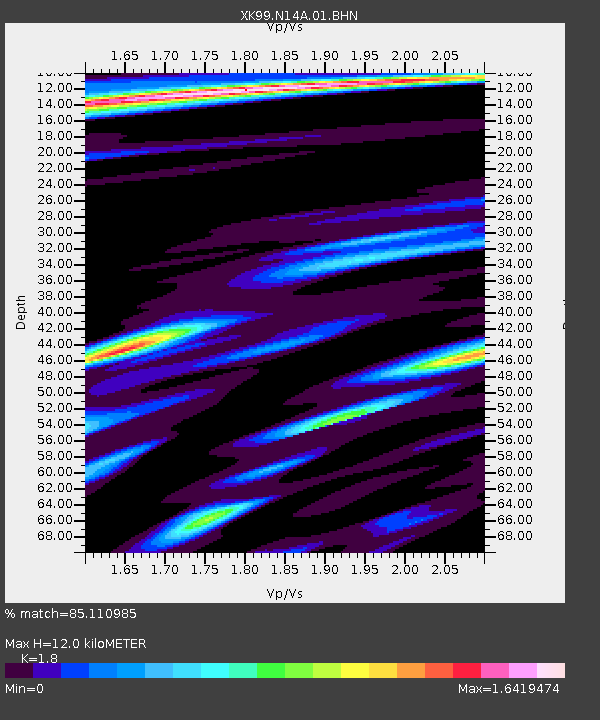
N14A North 14A - Earthquake Result Viewer
| Earthquake location: |
Southern Bolivia |
| Earthquake latitude/longitude: |
-20.9/-67.3 |
| Earthquake time(UTC): |
1999/09/15 (258) 03:01:24 GMT |
| Earthquake Depth: |
218 km |
| Earthquake Magnitude: |
6.0 MB, 6.4 MW, 6.4 MW |
| Earthquake Catalog/Contributor: |
WHDF/NEIC |
|
| Network: |
XK CDROM (Colorado) |
| Station: |
N14A North 14A |
| Lat/Lon: |
41.08 N/107.18 W |
| Elevation: |
2182 m |
|
| Distance: |
72.0 deg |
| Az: |
329.332 deg |
| Baz: |
140.898 deg |
| Ray Param: |
0.05337341 |
| Estimated Moho Depth: |
12.0 km |
| Estimated Crust Vp/Vs: |
1.80 |
| Assumed Crust Vp: |
6.159 km/s |
| Estimated Crust Vs: |
3.421 km/s |
| Estimated Crust Poisson's Ratio: |
0.28 |
|
| Radial Match: |
85.110985 % |
| Radial Bump: |
366 |
| Transverse Match: |
71.72368 % |
| Transverse Bump: |
400 |
| SOD ConfigId: |
287362 |
| Insert Time: |
2010-03-09 22:41:09.206 +0000 |
| GWidth: |
2.5 |
| Max Bumps: |
400 |
| Tol: |
0.001 |
|

Signal To Noise
| Channel | StoN | STA | LTA |
| XK:N14A:01:BHN:19990915T03:11:52.970005Z | 1.4440695 | 3.6505665E-7 | 2.5279715E-7 |
| XK:N14A:01:BHE:19990915T03:11:52.970005Z | 0.8166687 | 1.6014353E-7 | 1.9609364E-7 |
| XK:N14A:01:BHZ:19990915T03:11:52.970005Z | 9.263177 | 1.4058469E-6 | 1.5176725E-7 |
| Arrivals |
| Ps | 1.6 SECOND |
| PpPs | 5.3 SECOND |
| PsPs/PpSs | 6.9 SECOND |


