
Station XK N14A - North 14A
Network: XK99 - CDROM (Colorado)
Nearby stations (2 deg radius)
| Station | Name | (Lat, Lon) | Start / End | Elevation |
| N14A | North 14A | (41.08, -107.18) | 1999-07-22 / 2000-12-31 | 2.2 km |
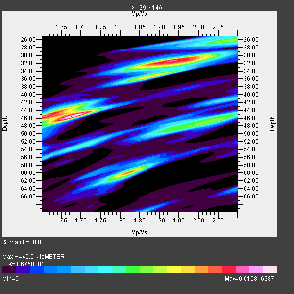
| Crust2 Type: | P1,orogen/46km, Urals, Tethian Orogen, 2 km seds. |
| Thickness Estimate: | 46 km |
| Thickness StdDev: | 7.2 km |
| Vp/Vs Estimate: | 1.68 |
| Vp/Vs StdDev: | 0.14 |
| Vs Estimate: | 3.677 km/s |
| Poisson's Ratio: | 0.22 |
| Peak Value: | 0.02 |
| Assumed Vp: | 6.159 km/s |
| Ps Weight: | 0.33333334 |
| PpPs Weight: | 0.33333334 |
| PsPs Weight: | 0.33333328 |
| Residual Complexity: | 0.864 |
| Nearby stations H: | 46 km +- 0.7 km |
| (2.0 deg) Vp/Vs: | 1.64 +- 0.06 |
1 with match > 90% ( 14.285714 %) and 7 with match > 80% ( 100.0 %) out of 7.
Download stack as xyz text file.
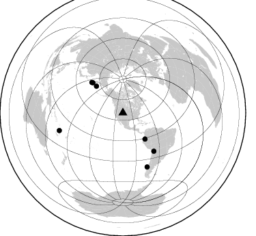
Azimuth Distribution of Events:
Prior Results for this Station
| Study | Thickness | Vp/Vs | Vp | Vs | Poissons Ratio | Extra |
| EARS | 46 km | 1.68 | 6.159 km/s | 3.677 km/s | 0.22 | |
| Crust2.0 | 46 km | 1.76 | 6.159 km/s | 3.507 km/s | 0.26 | P1,orogen/46km, Urals, Tethian Orogen, 2 km seds. |
| Global Maxima | 46 km | 1.68 | 6.159 km/s | 3.677 km/s | 0.22 | amp=0.015816987 |
| Local Maxima 1 | 32 km | 1.92 | 6.159 km/s | 3.203 km/s | 0.31 | amp=0.01358273 |
| Local Maxima 2 | 60 km | 1.82 | 6.159 km/s | 3.384 km/s | 0.28 | amp=0.012248598 |
| Local Maxima 3 | 45 km | 1.61 | 6.159 km/s | 3.819 km/s | 0.19 | amp=0.0120558 |
| Local Maxima 4 | 35 km | 1.90 | 6.159 km/s | 3.246 km/s | 0.31 | amp=0.0077376314 |
| Predicted Arrivals for vertical incidence (zero ray parameter) | |
| Ps | 4.99 SECOND |
| PpPs | 19.76 SECOND |
| PsPs/PpSs | 24.75 SECOND |
Events Processed for this Station
Download zip of receiver functions as SAC
Plot maxima for each earthquake.
Events Used in the Stack
(7 events)| Radial Match | Distance | Baz | FERegion | Time | Lat/Lon | Depth | Magnitude |
| 90.35986 | 86.4 deg | 155.816 deg | Off Coast Of Southern Chile | 1999/08/22 09:35:39 GMT | (-40.5, -74.8) | 33 km | 6.2 MB, 5.8 MS, 6.4 MW, 6.2 MW |
| 89.50252 | 62.3 deg | 314.954 deg | Near East Coast Of Kamchatka | 1999/09/18 21:28:33 GMT | (51.2, 157.6) | 60 km | 5.9 MB, 5.6 MS, 6.2 MW, 6.0 MW |
| 88.57527 | 55.0 deg | 314.961 deg | Komandorskiye Ostrova Region | 1999/09/28 05:00:42 GMT | (54.6, 168.3) | 33 km | 5.4 MB, 6.1 MS, 6.1 MW, 6.1 MW |
| 86.884705 | 63.7 deg | 314.242 deg | Kuril Islands | 1999/08/06 00:32:41 GMT | (49.9, 156.3) | 58 km | 5.5 MB, 5.5 MS, 5.9 MW, 5.8 MW |
| 85.89561 | 50.0 deg | 139.835 deg | Ecuador | 1999/08/28 12:40:06 GMT | (-1.3, -77.5) | 196 km | 5.9 MB, 6.3 MW, 6.2 MW |
| 85.110985 | 72.0 deg | 140.898 deg | Southern Bolivia | 1999/09/15 03:01:24 GMT | (-20.9, -67.3) | 218 km | 6.0 MB, 6.4 MW, 6.4 MW |
| 83.92215 | 96.6 deg | 254.479 deg | Vanuatu Islands | 1999/08/22 12:40:45 GMT | (-16.1, 168.0) | 33 km | 6.3 MB, 6.2 MS, 6.5 MW, 6.5 MW |
Losers
(0 events)| Radial Match | Distance | Baz | FERegion | Time | Lat/Lon | Depth | Magnitude | Reason |
