You are here: Home > Network List > XK99 - CDROM (Colorado) Stations List
> Station N15A North 15 A > Earthquake Result Viewer
N15A North 15 A - Earthquake Result Viewer
| Earthquake location: |
Vanuatu Islands Region |
| Earthquake latitude/longitude: |
-19.5/173.8 |
| Earthquake time(UTC): |
2000/02/25 (056) 01:43:58 GMT |
| Earthquake Depth: |
33 km |
| Earthquake Magnitude: |
6.1 MB, 7.1 MS, 7.1 MW, 7.0 MW |
| Earthquake Catalog/Contributor: |
WHDF/NEIC |
|
| Network: |
XK CDROM (Colorado) |
| Station: |
N15A North 15 A |
| Lat/Lon: |
41.00 N/107.03 W |
| Elevation: |
2243 m |
|
| Distance: |
94.7 deg |
| Az: |
48.24 deg |
| Baz: |
248.36 deg |
| Ray Param: |
0.040950697 |
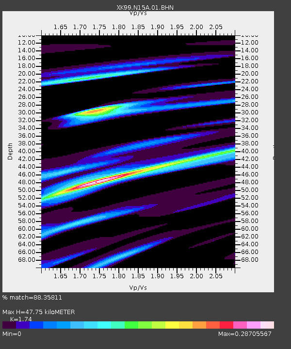
| Estimated Moho Depth: |
47.75 km |
| Estimated Crust Vp/Vs: |
1.74 |
| Assumed Crust Vp: |
6.159 km/s |
| Estimated Crust Vs: |
3.539 km/s |
| Estimated Crust Poisson's Ratio: |
0.25 |
|
| Radial Match: |
88.35811 % |
| Radial Bump: |
400 |
| Transverse Match: |
76.76615 % |
| Transverse Bump: |
400 |
| SOD ConfigId: |
3744 |
| Insert Time: |
2010-03-09 22:41:37.851 +0000 |
| GWidth: |
2.5 |
| Max Bumps: |
400 |
| Tol: |
0.001 |
|

Signal To Noise
| Channel | StoN | STA | LTA |
| XK:N15A:01:BHN:20000225T01:56:45.340012Z | 1.1590523 | 2.010525E-7 | 1.7346284E-7 |
| XK:N15A:01:BHE:20000225T01:56:45.340012Z | 1.3611417 | 2.5436742E-7 | 1.8687798E-7 |
| XK:N15A:01:BHZ:20000225T01:56:45.340012Z | 1.1123888 | 2.8702559E-7 | 2.5802632E-7 |
| Arrivals |
| Ps | 5.8 SECOND |
| PpPs | 21 SECOND |
| PsPs/PpSs | 27 SECOND |


