
Station XK N15A - North 15 A
Network: XK99 - CDROM (Colorado)
Nearby stations (2 deg radius)

| Station | Name | (Lat, Lon) | Start / End | Elevation |
| N15A | North 15 A | (41.00, -107.03) | 1999-08-08 / 2000-12-31 | 2243 m |
| Crust2 Type: | P1,orogen/46km, Urals, Tethian Orogen, 2 km seds. |
| Thickness Estimate: | 51 km |
| Thickness StdDev: | 4.0 km |
| Vp/Vs Estimate: | 1.70 |
| Vp/Vs StdDev: | 0.12 |
| Vs Estimate: | 3.623 km/s |
| Poisson's Ratio: | 0.24 |
| Peak Value: | 0.02 |
| Assumed Vp: | 6.159 km/s |
| Ps Weight: | 0.33333334 |
| PpPs Weight: | 0.33333334 |
| PsPs Weight: | 0.33333328 |
| Residual Complexity: | 0.766 |
| Nearby stations H: | +- |
| (2.0 deg) Vp/Vs: | +- |
7 with match > 90% ( 58.333332 %) and 12 with match > 80% ( 100.0 %) out of 12.
Download stack as xyz text file.
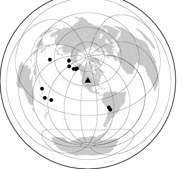
Azimuth Distribution of Events:
Prior Results for this Station
| Study | Thickness | Vp/Vs | Vp | Vs | Poissons Ratio | Extra |
| EARS | 51 km | 1.70 | 6.159 km/s | 3.623 km/s | 0.24 | |
| Crust2.0 | 46 km | 1.76 | 6.159 km/s | 3.507 km/s | 0.26 | P1,orogen/46km, Urals, Tethian Orogen, 2 km seds. |
| Global Maxima | 51 km | 1.70 | 6.159 km/s | 3.623 km/s | 0.24 | amp=0.020925112 |
| Local Maxima 1 | 44 km | 1.89 | 6.159 km/s | 3.25 km/s | 0.31 | amp=0.019004427 |
| Local Maxima 2 | 40 km | 2.10 | 6.159 km/s | 2.94 km/s | 0.35 | amp=0.011529473 |
| Local Maxima 3 | 52 km | 1.73 | 6.159 km/s | 3.57 km/s | 0.25 | amp=0.00889798 |
| Local Maxima 4 | 33 km | 1.70 | 6.159 km/s | 3.623 km/s | 0.24 | amp=0.007345778 |
| Predicted Arrivals for vertical incidence (zero ray parameter) | |
| Ps | 5.80 SECOND |
| PpPs | 22.36 SECOND |
| PsPs/PpSs | 28.16 SECOND |
Events Processed for this Station
Download zip of receiver functions as SAC
Plot maxima for each earthquake.
Events Used in the Stack
(12 events)| Radial Match | Distance | Baz | FERegion | Time | Lat/Lon | Depth | Magnitude |
| 97.97033 | 89.1 deg | 299.044 deg | Volcano Islands, Japan Region | 2000/03/28 11:00:22 GMT | (22.3, 143.7) | 126 km | 6.8 MB, 7.6 MS, 7.6 MW, 7.6 MW |
| 96.75985 | 34.3 deg | 314.905 deg | Kodiak Island Region, Alaska | 1999/12/06 23:12:33 GMT | (57.4, -154.5) | 66 km | 6.8 MB, 7.0 MW, 7.0 ML |
| 95.88788 | 74.5 deg | 141.713 deg | Jujuy Province, Argentina | 2000/05/12 18:43:18 GMT | (-23.5, -66.5) | 225 km | 6.2 MB, 7.2 MW, 7.1 MW |
| 95.06908 | 84.8 deg | 242.408 deg | Tonga Islands | 2000/01/08 16:47:20 GMT | (-16.9, -174.2) | 183 km | 6.5 MB, 6.6 MS, 7.2 MW, 7.0 ME |
| 93.71948 | 37.9 deg | 309.888 deg | Alaska Peninsula | 1999/10/13 01:33:40 GMT | (54.7, -161.2) | 30 km | 6.0 MB, 6.2 MS, 6.5 MW, 6.0 ML |
| 92.34741 | 48.5 deg | 307.689 deg | Andreanof Islands, Aleutian Is. | 2000/04/21 04:35:17 GMT | (51.4, -178.1) | 33 km | 6.0 MB, 5.7 MS, 6.2 ML, 6.0 MW |
| 90.24939 | 33.9 deg | 318.282 deg | Southern Alaska | 2000/05/19 20:34:26 GMT | (59.2, -153.1) | 80 km | 5.6 MB, 5.9 MW, 5.9 MW |
| 88.58721 | 34.3 deg | 314.811 deg | Kodiak Island Region, Alaska | 1999/12/07 00:19:49 GMT | (57.4, -154.5) | 41 km | 6.5 MB, 6.1 MS, 6.4 MW, 6.3 ML |
| 88.35811 | 94.7 deg | 248.36 deg | Vanuatu Islands Region | 2000/02/25 01:43:58 GMT | (-19.5, 173.8) | 33 km | 6.1 MB, 7.1 MS, 7.1 MW, 7.0 MW |
| 81.978775 | 69.2 deg | 141.567 deg | Northern Chile | 1999/11/30 04:01:53 GMT | (-18.9, -69.2) | 128 km | 6.2 MB, 6.6 MW, 6.5 MW |
| 81.81053 | 95.2 deg | 260.265 deg | Santa Cruz Islands | 1999/12/29 13:29:19 GMT | (-10.9, 165.4) | 33 km | 5.6 MB, 6.8 MS, 6.8 MW, 6.3 MW |
| 81.40474 | 56.4 deg | 316.47 deg | Komandorskiye Ostrova Region | 1999/11/26 00:29:00 GMT | (55.1, 165.4) | 33 km | 5.6 MB, 5.8 MS |
Losers
(0 events)| Radial Match | Distance | Baz | FERegion | Time | Lat/Lon | Depth | Magnitude | Reason |
