You are here: Home > Network List > GS - US Geological Survey Networks Stations List
> Station NE01 NE01 Arnold Nebraska > Earthquake Result Viewer
NE01 NE01 Arnold Nebraska - Earthquake Result Viewer
| Earthquake location: |
Near Coast Of Venezuela |
| Earthquake latitude/longitude: |
10.9/-62.9 |
| Earthquake time(UTC): |
2018/08/21 (233) 21:31:46 GMT |
| Earthquake Depth: |
154 km |
| Earthquake Magnitude: |
7.3 Mww |
| Earthquake Catalog/Contributor: |
NEIC PDE/us |
|
| Network: |
GS US Geological Survey Networks |
| Station: |
NE01 NE01 Arnold Nebraska |
| Lat/Lon: |
41.42 N/100.19 W |
| Elevation: |
829 m |
|
| Distance: |
44.7 deg |
| Az: |
319.59 deg |
| Baz: |
122.149 deg |
| Ray Param: |
0.07118587 |
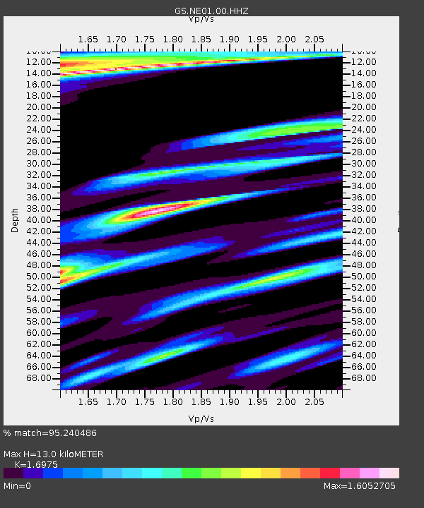
| Estimated Moho Depth: |
13.0 km |
| Estimated Crust Vp/Vs: |
1.70 |
| Assumed Crust Vp: |
6.483 km/s |
| Estimated Crust Vs: |
3.819 km/s |
| Estimated Crust Poisson's Ratio: |
0.23 |
|
| Radial Match: |
95.240486 % |
| Radial Bump: |
388 |
| Transverse Match: |
81.80913 % |
| Transverse Bump: |
400 |
| SOD ConfigId: |
2825771 |
| Insert Time: |
2018-09-04 21:46:05.146 +0000 |
| GWidth: |
2.5 |
| Max Bumps: |
400 |
| Tol: |
0.001 |
|

Signal To Noise
| Channel | StoN | STA | LTA |
| GS:NE01:00:HHZ:20180821T21:39:13.068993Z | 7.264184 | 1.2238037E-5 | 1.6847091E-6 |
| GS:NE01:00:HH1:20180821T21:39:13.068993Z | 2.4330919 | 3.7545642E-6 | 1.5431247E-6 |
| GS:NE01:00:HH2:20180821T21:39:13.068993Z | 3.399163 | 6.173256E-6 | 1.8161107E-6 |
| Arrivals |
| Ps | 1.5 SECOND |
| PpPs | 5.1 SECOND |
| PsPs/PpSs | 6.6 SECOND |


