
Station GS NE01 - NE01 Arnold Nebraska
Network: GS - US Geological Survey Networks
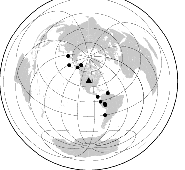
Nearby stations (2 deg radius)
| Station | Name | (Lat, Lon) | Start / End | Elevation |
| NE01 | NE01 Arnold Nebraska | (41.42, -100.19) | 2018-07-18 / 2599-12-31 | 829 m |
| Crust2 Type: | D5,thick Platform 2 km seds. |
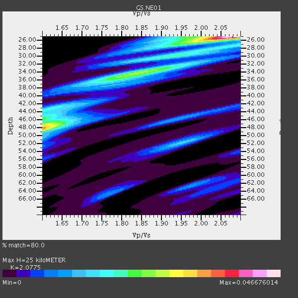
| Thickness Estimate: | 25 km |
| Thickness StdDev: | 9.5 km |
| Vp/Vs Estimate: | 2.08 |
| Vp/Vs StdDev: | 0.21 |
| Vs Estimate: | 3.12 km/s |
| Poisson's Ratio: | 0.35 |
| Peak Value: | 0.05 |
| Assumed Vp: | 6.483 km/s |
| Ps Weight: | 0.33333334 |
| PpPs Weight: | 0.33333334 |
| PsPs Weight: | 0.33333328 |
| Residual Complexity: | 0.737 |
| Nearby stations H: | +- |
| (2.0 deg) Vp/Vs: | +- |
3 with match > 90% ( 7.894737 %) and 11 with match > 80% ( 28.947369 %) out of 38.
Download stack as xyz text file.
Azimuth Distribution of Events:
Prior Results for this Station
| Study | Thickness | Vp/Vs | Vp | Vs | Poissons Ratio | Extra |
| EARS | 25 km | 2.08 | 6.483 km/s | 3.12 km/s | 0.35 | |
| Crust2.0 | 46 km | 1.78 | 6.483 km/s | 3.648 km/s | 0.27 | D5,thick Platform 2 km seds. |
| Global Maxima | 25 km | 2.08 | 6.483 km/s | 3.12 km/s | 0.35 | amp=0.046676014 |
| Local Maxima 1 | 48 km | 1.60 | 6.483 km/s | 4.052 km/s | 0.18 | amp=0.033004705 |
| Local Maxima 2 | 34 km | 1.85 | 6.483 km/s | 3.514 km/s | 0.29 | amp=0.025075918 |
| Local Maxima 3 | 25 km | 1.96 | 6.483 km/s | 3.307 km/s | 0.32 | amp=0.015071522 |
| Local Maxima 4 | 52 km | 1.95 | 6.483 km/s | 3.32 km/s | 0.32 | amp=0.014553955 |
| Predicted Arrivals for vertical incidence (zero ray parameter) | |
| Ps | 4.16 SECOND |
| PpPs | 11.87 SECOND |
| PsPs/PpSs | 16.02 SECOND |
Events Processed for this Station
Download zip of receiver functions as SAC
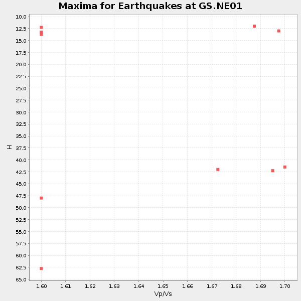
Plot maxima for each earthquake.
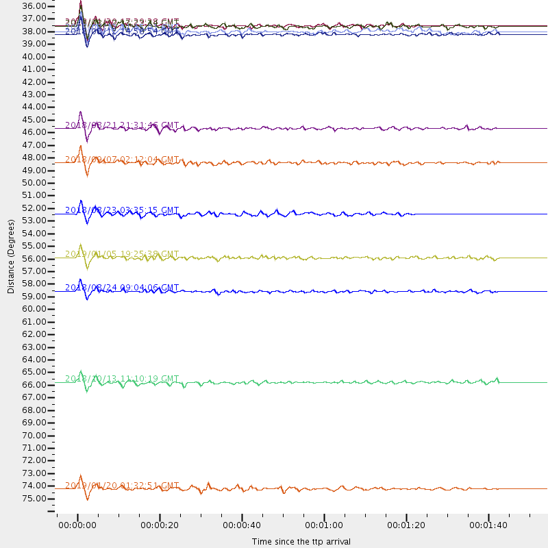
Events Used in the Stack
(11 events)| Radial Match | Distance | Baz | FERegion | Time | Lat/Lon | Depth | Magnitude |
| 95.240486 | 44.7 deg | 122.149 deg | Near Coast Of Venezuela | 2018/08/21 21:31:46 GMT | (10.9, -62.9) | 154 km | 7.3 Mww |
| 93.78569 | 75.9 deg | 154.53 deg | Near Coast Of Central Chile | 2019/01/20 01:32:51 GMT | (-30.1, -71.4) | 53 km | 6.7 mww |
| 91.94122 | 35.7 deg | 320.943 deg | Southern Alaska | 2018/11/30 17:29:28 GMT | (61.3, -149.9) | 43 km | 6.6 ml |
| 89.70747 | 55.9 deg | 145.055 deg | Western Brazil | 2019/01/05 19:25:38 GMT | (-8.1, -71.6) | 575 km | 6.8 Mww |
| 88.94461 | 36.5 deg | 335.291 deg | Northern Alaska | 2018/08/12 14:58:54 GMT | (69.6, -145.3) | 2.2 km | 6.3 ml |
| 88.60489 | 47.7 deg | 150.604 deg | Ecuador | 2018/09/07 02:12:04 GMT | (-2.3, -78.9) | 94 km | 6.2 Mww |
| 86.85666 | 66.7 deg | 320.463 deg | Northwest Of Kuril Islands | 2018/10/13 11:10:19 GMT | (52.7, 153.7) | 397 km | 6.7 Mi |
| 86.57208 | 58.8 deg | 145.739 deg | Peru-Brazil Border Region | 2018/08/24 09:04:06 GMT | (-11.0, -70.8) | 609 km | 7.1 Mww |
| 83.61033 | 52.1 deg | 309.279 deg | Andreanof Islands, Aleutian Is. | 2018/08/23 03:35:15 GMT | (51.5, -177.9) | 44 km | 6.0 Ml |
| 83.31179 | 36.2 deg | 335.482 deg | Northern Alaska | 2018/08/12 21:15:01 GMT | (69.5, -144.4) | 1.7 km | 6.0 Mww |
| 81.03514 | 35.8 deg | 150.356 deg | Costa Rica | 2018/08/17 23:22:24 GMT | (8.8, -83.2) | 15 km | 6.1 Mww |
Losers
(27 events)| Radial Match | Distance | Baz | FERegion | Time | Lat/Lon | Depth | Magnitude | Reason |
| 77.19385 | 67.0 deg | 144.331 deg | Central Bolivia | 2019/03/15 05:03:50 GMT | (-17.9, -65.9) | 358 km | 6.3 Mww | |
| 74.165054 | 92.3 deg | 249.429 deg | Fiji Islands Region | 2018/08/19 04:28:58 GMT | (-17.0, -178.0) | 416 km | 6.8 mww | |
| 73.12305 | 61.0 deg | 320.03 deg | Near East Coast Of Kamchatka | 2018/11/14 21:21:50 GMT | (55.6, 162.0) | 50 km | 6.1 Mww | |
| 72.73175 | 95.0 deg | 250.169 deg | Fiji Islands | 2018/09/06 15:56:41 GMT | (-18.3, 179.3) | 657 km | 5.7 mb | |
| 70.68801 | 42.5 deg | 143.256 deg | Colombia | 2019/03/23 19:21:16 GMT | (4.6, -76.3) | 113 km | 6.1 Mww | |
| 67.70918 | 83.8 deg | 315.158 deg | Near East Coast Of Honshu, Japan | 2018/07/31 08:42:20 GMT | (37.2, 141.2) | 10 km | 5.4 Mww | |
| 67.66653 | 52.3 deg | 309.16 deg | Andreanof Islands, Aleutian Is. | 2018/08/17 04:35:29 GMT | (51.3, -178.2) | 25 km | 5.8 Ml | |
| 67.27194 | 67.1 deg | 148.297 deg | Northern Chile | 2018/11/01 22:19:51 GMT | (-19.6, -69.3) | 102 km | 6.2 Mww | |
| 66.96304 | 98.0 deg | 316.362 deg | Ryukyu Islands, Japan | 2018/09/15 00:08:20 GMT | (26.7, 129.6) | 5.9 km | 5.6 Mww | |
| 65.41174 | 77.2 deg | 315.177 deg | Off Coast Of Hokkaido, Japan | 2019/03/02 03:22:52 GMT | (41.9, 146.9) | 10 km | 6.0 Mww | |
| 63.54592 | 50.3 deg | 105.453 deg | North Atlantic Ocean | 2018/11/27 19:34:46 GMT | (15.6, -49.9) | 10 km | 5.5 Mww | |
| 62.99967 | 93.3 deg | 249.017 deg | Fiji Islands Region | 2018/09/06 05:13:39 GMT | (-18.0, -178.5) | 531 km | 5.5 Mww | |
| 62.946476 | 59.9 deg | 319.002 deg | Komandorskiye Ostrova Region | 2018/12/24 12:41:19 GMT | (55.4, 164.4) | 10 km | 6.1 Mww | |
| 62.021454 | 36.4 deg | 335.364 deg | Northern Alaska | 2018/08/12 16:02:09 GMT | (69.5, -145.0) | 1.0 km | 5.1 Mww | |
| 60.639477 | 93.4 deg | 248.685 deg | Fiji Islands Region | 2018/08/19 02:18:52 GMT | (-18.3, -178.4) | 618 km | 5.7 mb | |
| 60.146557 | 93.8 deg | 249.477 deg | Fiji Islands Region | 2019/01/28 16:00:16 GMT | (-18.0, -179.3) | 621 km | 5.5 Mww | |
| 55.057148 | 38.3 deg | 141.608 deg | Panama-Colombia Border Region | 2018/08/18 19:39:07 GMT | (8.8, -77.3) | 10 km | 5.6 Mww | |
| 54.85306 | 52.5 deg | 308.76 deg | Andreanof Islands, Aleutian Is. | 2019/01/05 18:47:11 GMT | (51.0, -178.2) | 35 km | 6.0 Mi | |
| 53.058178 | 93.3 deg | 249.209 deg | Fiji Islands Region | 2019/03/10 08:12:25 GMT | (-17.8, -178.7) | 567 km | 6.2 Mww | |
| 49.76484 | 93.3 deg | 248.447 deg | Fiji Islands Region | 2018/09/30 10:52:23 GMT | (-18.4, -178.1) | 551 km | 6.6 mww | |
| 49.64508 | 47.9 deg | 308.482 deg | Fox Islands, Aleutian Islands | 2018/08/25 16:50:04 GMT | (52.3, -171.2) | 35 km | 5.5 Ml | |
| 46.04214 | 78.9 deg | 317.445 deg | Hokkaido, Japan Region | 2018/12/29 19:08:30 GMT | (42.3, 143.2) | 58 km | 5.5 mb | |
| 45.18547 | 44.1 deg | 143.45 deg | Colombia | 2019/01/28 21:07:10 GMT | (3.1, -75.7) | 15 km | 5.5 Mww | |
| 45.086727 | 98.2 deg | 240.493 deg | Kermadec Islands Region | 2019/03/15 17:53:33 GMT | (-27.6, -176.3) | 10 km | 5.5 Mww | |
| 42.93531 | 35.7 deg | 320.701 deg | Southern Alaska | 2018/11/30 17:35:37 GMT | (61.2, -149.9) | 39 km | 5.8 Ml | |
| 39.025265 | 94.2 deg | 297.358 deg | Mariana Islands Region | 2018/10/26 09:05:39 GMT | (17.4, 147.9) | 10 km | 5.7 mww | |
| 38.61317 | 49.6 deg | 74.881 deg | Northern Mid-Atlantic Ridge | 2019/02/14 19:57:05 GMT | (35.4, -36.1) | 10 km | 6.1 Mww |

