You are here: Home > Network List > XM99 - Rio Grande Seismic Transect Stations List
> Station MB05 Magmabody05 > Earthquake Result Viewer
MB05 Magmabody05 - Earthquake Result Viewer
| Earthquake location: |
South Of Fiji Islands |
| Earthquake latitude/longitude: |
-24.4/179.0 |
| Earthquake time(UTC): |
2000/03/18 (078) 23:22:52 GMT |
| Earthquake Depth: |
552 km |
| Earthquake Magnitude: |
5.1 MB, 5.5 MW |
| Earthquake Catalog/Contributor: |
WHDF/NEIC |
|
| Network: |
XM Rio Grande Seismic Transect |
| Station: |
MB05 Magmabody05 |
| Lat/Lon: |
34.66 N/108.01 W |
| Elevation: |
2143 m |
|
| Distance: |
90.7 deg |
| Az: |
52.032 deg |
| Baz: |
240.72 deg |
| Ray Param: |
0.04138871 |
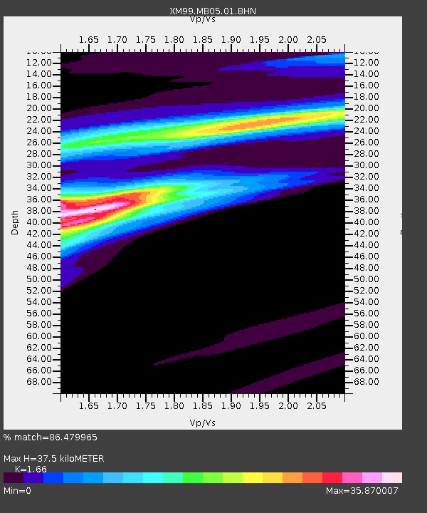
| Estimated Moho Depth: |
37.5 km |
| Estimated Crust Vp/Vs: |
1.66 |
| Assumed Crust Vp: |
6.496 km/s |
| Estimated Crust Vs: |
3.913 km/s |
| Estimated Crust Poisson's Ratio: |
0.22 |
|
| Radial Match: |
86.479965 % |
| Radial Bump: |
349 |
| Transverse Match: |
84.85711 % |
| Transverse Bump: |
320 |
| SOD ConfigId: |
16820 |
| Insert Time: |
2010-02-26 17:35:15.607 +0000 |
| GWidth: |
2.5 |
| Max Bumps: |
400 |
| Tol: |
0.001 |
|
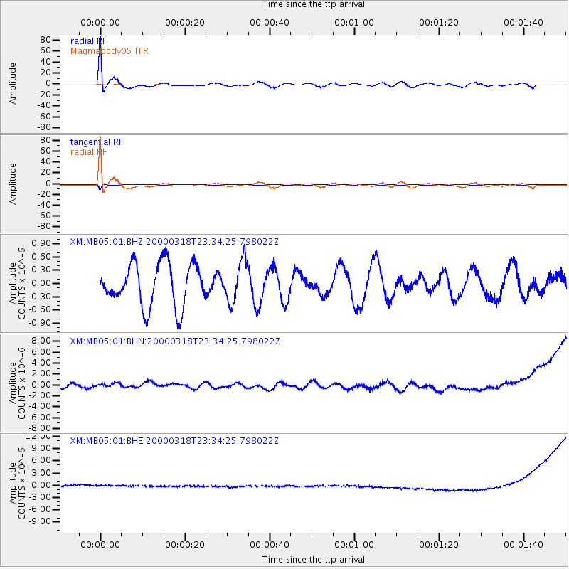
Signal To Noise
| Channel | StoN | STA | LTA |
| XM:MB05:01:BHN:20000318T23:34:25.798022Z | 1.2558903 | 6.556958E-7 | 5.2209646E-7 |
| XM:MB05:01:BHE:20000318T23:34:25.798022Z | 0.9971118 | 9.656718E-7 | 9.68469E-7 |
| XM:MB05:01:BHZ:20000318T23:34:25.798022Z | 0.9772747 | 4.6664556E-7 | 4.774968E-7 |
| Arrivals |
| Ps | 3.9 SECOND |
| PpPs | 15 SECOND |
| PsPs/PpSs | 19 SECOND |


