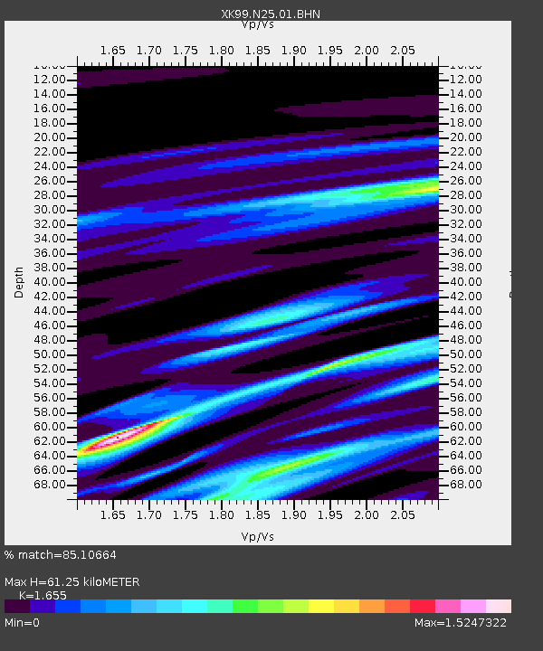
N25 North 25 - Earthquake Result Viewer

Earthquake location: Kodiak Island Region, Alaska
Earthquake latitude/longitude: 57.4/-154.5
Earthquake time(UTC): 1999/12/07 (341) 00:19:49 GMT
Earthquake Depth: 41 km
Earthquake Magnitude: 6.5 MB, 6.1 MS, 6.4 MW, 6.3 ML
Earthquake Catalog/Contributor: WHDF/NEIC
Network: XK CDROM (Colorado)
Station: N25 North 25
Lat/Lon: 40.13 N/106.70 W
Elevation: 2554 m
Distance: 35.1 deg
Az: 98.493 deg
Baz: 315.652 deg
Ray Param: 0.07733351
Estimated Moho Depth: 61.25 km
Estimated Crust Vp/Vs: 1.65
Assumed Crust Vp: 6.159 km/s
Estimated Crust Vs: 3.721 km/s
Estimated Crust Poisson's Ratio: 0.21
Radial Match: 85.10664 %
Radial Bump: 400
Transverse Match: 62.785355 %
Transverse Bump: 400
SOD ConfigId: 287362
Insert Time: 2010-03-09 22:43:39.019 +0000
GWidth: 2.5
Max Bumps: 400
Tol: 0.001

Signal To Noise

ChannelStoNSTALTA
XK:N25:01:BHN:19991207T00:26:08.386001Z1.06640248.2011087E-77.6904445E-7
XK:N25:01:BHE:19991207T00:26:08.386001Z1.6792591.7570113E-61.0463016E-6
XK:N25:01:BHZ:19991207T00:26:08.386001Z3.18515782.2047384E-66.9219124E-7
Arrivals
Ps7.0 SECOND
PpPs25 SECOND
PsPs/PpSs32 SECOND