
Station XK N25 - North 25
Network: XK99 - CDROM (Colorado)
Nearby stations (2 deg radius)
| Station | Name | (Lat, Lon) | Start / End | Elevation |
| N25 | North 25 | (40.13, -106.70) | 1999-06-11 / 2000-12-31 | 2554 m |
| Crust2 Type: | P1,orogen/46km, Urals, Tethian Orogen, 2 km seds. |
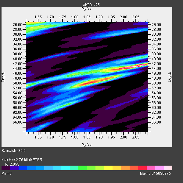
| Thickness Estimate: | 43 km |
| Thickness StdDev: | 9.6 km |
| Vp/Vs Estimate: | 2.06 |
| Vp/Vs StdDev: | 0.16 |
| Vs Estimate: | 2.997 km/s |
| Poisson's Ratio: | 0.34 |
| Peak Value: | 0.02 |
| Assumed Vp: | 6.159 km/s |
| Ps Weight: | 0.33333334 |
| PpPs Weight: | 0.33333334 |
| PsPs Weight: | 0.33333328 |
| Residual Complexity: | 0.771 |
| Nearby stations H: | +- |
| (2.0 deg) Vp/Vs: | +- |
5 with match > 90% ( 38.46154 %) and 13 with match > 80% ( 100.0 %) out of 13.
Download stack as xyz text file.
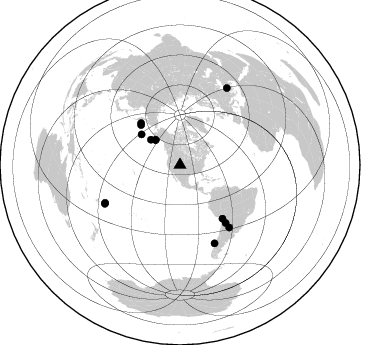
Azimuth Distribution of Events:
Prior Results for this Station
| Study | Thickness | Vp/Vs | Vp | Vs | Poissons Ratio | Extra |
| EARS | 43 km | 2.06 | 6.159 km/s | 2.997 km/s | 0.34 | |
| Crust2.0 | 46 km | 1.76 | 6.159 km/s | 3.507 km/s | 0.26 | P1,orogen/46km, Urals, Tethian Orogen, 2 km seds. |
| Global Maxima | 43 km | 2.06 | 6.159 km/s | 2.997 km/s | 0.34 | amp=0.015036375 |
| Local Maxima 1 | 50 km | 1.85 | 6.159 km/s | 3.338 km/s | 0.29 | amp=0.012287588 |
| Local Maxima 2 | 25 km | 1.62 | 6.159 km/s | 3.796 km/s | 0.19 | amp=0.010268837 |
| Local Maxima 3 | 51 km | 1.60 | 6.159 km/s | 3.849 km/s | 0.18 | amp=0.008176441 |
| Local Maxima 4 | 27 km | 1.66 | 6.159 km/s | 3.704 km/s | 0.22 | amp=0.0076554534 |
| Predicted Arrivals for vertical incidence (zero ray parameter) | |
| Ps | 7.32 SECOND |
| PpPs | 21.21 SECOND |
| PsPs/PpSs | 28.53 SECOND |
Events Processed for this Station
Download zip of receiver functions as SAC
Plot maxima for each earthquake.
Events Used in the Stack
(13 events)| Radial Match | Distance | Baz | FERegion | Time | Lat/Lon | Depth | Magnitude |
| 95.47767 | 73.6 deg | 141.83 deg | Jujuy Province, Argentina | 2000/05/12 18:43:18 GMT | (-23.5, -66.5) | 225 km | 6.2 MB, 7.2 MW, 7.1 MW |
| 95.03879 | 84.6 deg | 242.705 deg | Tonga Islands | 2000/01/08 16:47:20 GMT | (-16.9, -174.2) | 183 km | 6.5 MB, 6.6 MS, 7.2 MW, 7.0 ME |
| 94.01503 | 85.4 deg | 156.127 deg | Off Coast Of Southern Chile | 1999/08/22 09:35:39 GMT | (-40.5, -74.8) | 33 km | 6.2 MB, 5.8 MS, 6.4 MW, 6.2 MW |
| 92.12908 | 57.2 deg | 316.954 deg | Komandorskiye Ostrova Region | 1999/11/26 00:29:00 GMT | (55.1, 165.4) | 33 km | 5.6 MB, 5.8 MS |
| 90.19852 | 35.1 deg | 315.743 deg | Kodiak Island Region, Alaska | 1999/12/06 23:12:33 GMT | (57.4, -154.5) | 66 km | 6.8 MB, 7.0 MW, 7.0 ML |
| 88.24991 | 79.3 deg | 141.678 deg | Santiago Del Estero Prov., Arg. | 2000/04/23 09:27:23 GMT | (-28.3, -63.0) | 608 km | 6.6 MB, 7.0 MW, 7.0 MW |
| 87.59113 | 38.6 deg | 310.736 deg | Alaska Peninsula | 1999/10/13 01:33:40 GMT | (54.7, -161.2) | 30 km | 6.0 MB, 6.2 MS, 6.5 MW, 6.0 ML |
| 86.635765 | 55.9 deg | 315.555 deg | Komandorskiye Ostrova Region | 1999/09/28 05:00:42 GMT | (54.6, 168.3) | 33 km | 5.4 MB, 6.1 MS, 6.1 MW, 6.1 MW |
| 86.23812 | 90.3 deg | 31.492 deg | Turkey | 1999/08/17 00:01:39 GMT | (40.7, 29.9) | 17 km | 6.3 MB, 7.8 MS, 7.7 ME, 7.6 MW |
| 85.808945 | 68.3 deg | 141.649 deg | Northern Chile | 1999/11/30 04:01:53 GMT | (-18.9, -69.2) | 128 km | 6.2 MB, 6.6 MW, 6.5 MW |
| 85.10664 | 35.1 deg | 315.652 deg | Kodiak Island Region, Alaska | 1999/12/07 00:19:49 GMT | (57.4, -154.5) | 41 km | 6.5 MB, 6.1 MS, 6.4 MW, 6.3 ML |
| 82.115616 | 83.7 deg | 243.248 deg | Tonga Islands | 1999/12/07 21:29:49 GMT | (-15.9, -174.0) | 138 km | 6.2 MB, 6.4 MW, 6.4 MW |
| 81.27695 | 49.2 deg | 308.365 deg | Andreanof Islands, Aleutian Is. | 2000/04/21 04:35:17 GMT | (51.4, -178.1) | 33 km | 6.0 MB, 5.7 MS, 6.2 ML, 6.0 MW |
Losers
(0 events)| Radial Match | Distance | Baz | FERegion | Time | Lat/Lon | Depth | Magnitude | Reason |
