You are here: Home > Network List > XK99 - CDROM (Colorado) Stations List
> Station N25 North 25 > Earthquake Result Viewer
N25 North 25 - Earthquake Result Viewer
| Earthquake location: |
Kodiak Island Region, Alaska |
| Earthquake latitude/longitude: |
57.4/-154.5 |
| Earthquake time(UTC): |
1999/12/06 (340) 23:12:33 GMT |
| Earthquake Depth: |
66 km |
| Earthquake Magnitude: |
6.8 MB, 7.0 MW, 7.0 ML |
| Earthquake Catalog/Contributor: |
WHDF/NEIC |
|
| Network: |
XK CDROM (Colorado) |
| Station: |
N25 North 25 |
| Lat/Lon: |
40.13 N/106.70 W |
| Elevation: |
2554 m |
|
| Distance: |
35.1 deg |
| Az: |
98.589 deg |
| Baz: |
315.743 deg |
| Ray Param: |
0.07724173 |
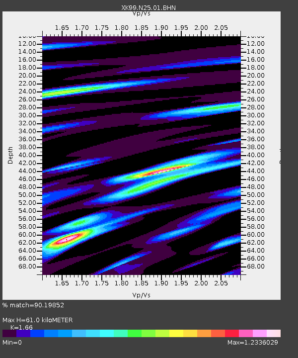
| Estimated Moho Depth: |
61.0 km |
| Estimated Crust Vp/Vs: |
1.66 |
| Assumed Crust Vp: |
6.159 km/s |
| Estimated Crust Vs: |
3.71 km/s |
| Estimated Crust Poisson's Ratio: |
0.22 |
|
| Radial Match: |
90.19852 % |
| Radial Bump: |
368 |
| Transverse Match: |
79.53363 % |
| Transverse Bump: |
400 |
| SOD ConfigId: |
287362 |
| Insert Time: |
2010-03-09 22:43:40.163 +0000 |
| GWidth: |
2.5 |
| Max Bumps: |
400 |
| Tol: |
0.001 |
|

Signal To Noise
| Channel | StoN | STA | LTA |
| XK:N25:01:BHN:19991206T23:18:50.185015Z | 5.7466483 | 1.1121382E-6 | 1.9352815E-7 |
| XK:N25:01:BHE:19991206T23:18:50.185015Z | 7.2087784 | 1.176302E-6 | 1.6317634E-7 |
| XK:N25:01:BHZ:19991206T23:18:50.185015Z | 20.194141 | 2.3391437E-6 | 1.1583278E-7 |
| Arrivals |
| Ps | 7.0 SECOND |
| PpPs | 24 SECOND |
| PsPs/PpSs | 32 SECOND |


