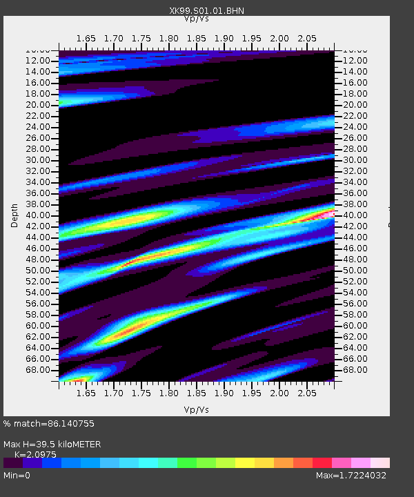
S01 South 01 - Earthquake Result Viewer

Earthquake location: Kodiak Island Region, Alaska
Earthquake latitude/longitude: 56.4/-152.9
Earthquake time(UTC): 1999/05/07 (127) 14:13:52 GMT
Earthquake Depth: 20 km
Earthquake Magnitude: 5.7 MB, 6.1 MS, 6.4 MW, 5.7 ME
Earthquake Catalog/Contributor: WHDF/NEIC
Network: XK CDROM (Colorado)
Station: S01 South 01
Lat/Lon: 37.24 N/105.46 W
Elevation: 2405 m
Distance: 36.8 deg
Az: 100.923 deg
Baz: 316.859 deg
Ray Param: 0.07646086
Estimated Moho Depth: 39.5 km
Estimated Crust Vp/Vs: 2.10
Assumed Crust Vp: 6.316 km/s
Estimated Crust Vs: 3.011 km/s
Estimated Crust Poisson's Ratio: 0.35
Radial Match: 86.140755 %
Radial Bump: 400
Transverse Match: 77.75274 %
Transverse Bump: 400
SOD ConfigId: 287362
Insert Time: 2010-03-09 22:44:19.900 +0000
GWidth: 2.5
Max Bumps: 400
Tol: 0.001

Signal To Noise

ChannelStoNSTALTA
XK:S01:01:BHN:19990507T14:20:28.081008Z1.60986882.2296011E-71.3849584E-7
XK:S01:01:BHE:19990507T14:20:28.081008Z2.76421883.4524152E-71.2489659E-7
XK:S01:01:BHZ:19990507T14:20:28.081008Z4.65789653.4621226E-77.432803E-8
Arrivals
Ps7.3 SECOND
PpPs18 SECOND
PsPs/PpSs26 SECOND