
Station XK S01 - South 01
Network: XK99 - CDROM (Colorado)
Nearby stations (2 deg radius)
| Station | Name | (Lat, Lon) | Start / End | Elevation |
| S01 | South 01 | (37.24, -105.46) | 1999-04-22 / 2000-12-31 | 2405 m |
| Crust2 Type: | PC,orogen/45km, Orogen, 1 km seds. |
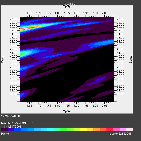
| Thickness Estimate: | 31 km |
| Thickness StdDev: | 7.9 km |
| Vp/Vs Estimate: | 1.62 |
| Vp/Vs StdDev: | 0.14 |
| Vs Estimate: | 3.905 km/s |
| Poisson's Ratio: | 0.19 |
| Peak Value: | 0.22 |
| Assumed Vp: | 6.316 km/s |
| Ps Weight: | 0.33333334 |
| PpPs Weight: | 0.33333334 |
| PsPs Weight: | 0.33333328 |
| Residual Complexity: | 0.561 |
| Nearby stations H: | +- |
| (2.0 deg) Vp/Vs: | +- |
2 with match > 90% ( 12.5 %) and 16 with match > 80% ( 100.0 %) out of 16.
Download stack as xyz text file.
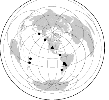
Azimuth Distribution of Events:
Prior Results for this Station
| Study | Thickness | Vp/Vs | Vp | Vs | Poissons Ratio | Extra |
| EARS | 31 km | 1.62 | 6.316 km/s | 3.905 km/s | 0.19 | |
| Crust2.0 | 45 km | 1.76 | 6.316 km/s | 3.587 km/s | 0.26 | PC,orogen/45km, Orogen, 1 km seds. |
| Global Maxima | 31 km | 1.62 | 6.316 km/s | 3.905 km/s | 0.19 | amp=0.22132906 |
| Local Maxima 1 | 44 km | 1.60 | 6.316 km/s | 3.947 km/s | 0.18 | amp=0.11561499 |
| Local Maxima 2 | 46 km | 1.60 | 6.316 km/s | 3.947 km/s | 0.18 | amp=0.04879442 |
| Local Maxima 3 | 52 km | 1.61 | 6.316 km/s | 3.935 km/s | 0.18 | amp=0.038651083 |
| Local Maxima 4 | 30 km | 1.67 | 6.316 km/s | 3.782 km/s | 0.22 | amp=0.034306765 |
| Predicted Arrivals for vertical incidence (zero ray parameter) | |
| Ps | 3.06 SECOND |
| PpPs | 12.95 SECOND |
| PsPs/PpSs | 16.01 SECOND |
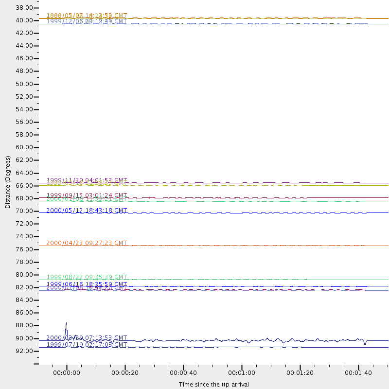
Events Processed for this Station
Download zip of receiver functions as SAC
Plot maxima for each earthquake.
Events Used in the Stack
(16 events)| Radial Match | Distance | Baz | FERegion | Time | Lat/Lon | Depth | Magnitude |
| 93.632454 | 70.8 deg | 142.276 deg | Jujuy Province, Argentina | 2000/05/12 18:43:18 GMT | (-23.5, -66.5) | 225 km | 6.2 MB, 7.2 MW, 7.1 MW |
| 90.99999 | 37.8 deg | 318.216 deg | Kodiak Island Region, Alaska | 1999/12/06 23:12:33 GMT | (57.4, -154.5) | 66 km | 6.8 MB, 7.0 MW, 7.0 ML |
| 89.867874 | 82.3 deg | 156.868 deg | Off Coast Of Southern Chile | 1999/08/22 09:35:39 GMT | (-40.5, -74.8) | 33 km | 6.2 MB, 5.8 MS, 6.4 MW, 6.2 MW |
| 89.60421 | 37.8 deg | 318.13 deg | Kodiak Island Region, Alaska | 1999/12/07 00:19:49 GMT | (57.4, -154.5) | 41 km | 6.5 MB, 6.1 MS, 6.4 MW, 6.3 ML |
| 88.600746 | 84.1 deg | 243.772 deg | Tonga Islands | 2000/01/08 16:47:20 GMT | (-16.9, -174.2) | 183 km | 6.5 MB, 6.6 MS, 7.2 MW, 7.0 ME |
| 87.36075 | 68.1 deg | 141.488 deg | Southern Bolivia | 1999/09/15 03:01:24 GMT | (-20.9, -67.3) | 218 km | 6.0 MB, 6.4 MW, 6.4 MW |
| 87.17199 | 65.5 deg | 141.983 deg | Northern Chile | 1999/11/30 04:01:53 GMT | (-18.9, -69.2) | 128 km | 6.2 MB, 6.6 MW, 6.5 MW |
| 86.140755 | 36.8 deg | 316.859 deg | Kodiak Island Region, Alaska | 1999/05/07 14:13:52 GMT | (56.4, -152.9) | 20 km | 5.7 MB, 6.1 MS, 6.4 MW, 5.7 ME |
| 85.36533 | 76.4 deg | 142.229 deg | Santiago Del Estero Prov., Arg. | 2000/04/23 09:27:23 GMT | (-28.3, -63.0) | 608 km | 6.6 MB, 7.0 MW, 7.0 MW |
| 83.30918 | 92.9 deg | 236.66 deg | Kermadec Islands Region | 2000/03/29 07:13:53 GMT | (-28.1, -176.3) | 10 km | 5.1 MB, 5.9 MS, 6.1 MW, 5.7 MW |
| 83.06076 | 84.2 deg | 243.355 deg | Tonga Islands | 2000/01/26 13:26:50 GMT | (-17.3, -174.0) | 33 km | 5.9 MB, 6.0 MS, 6.4 MW, 6.3 MW |
| 82.46055 | 66.0 deg | 316.864 deg | Near East Coast Of Kamchatka | 1999/09/18 21:28:33 GMT | (51.2, 157.6) | 60 km | 5.9 MB, 5.6 MS, 6.2 MW, 6.0 MW |
| 82.14447 | 68.7 deg | 145.153 deg | Near Coast Of Northern Chile | 2000/01/08 11:59:21 GMT | (-23.2, -70.1) | 36 km | 5.8 MB, 5.9 MS, 6.4 MW, 6.1 ME |
| 81.5084 | 83.6 deg | 243.12 deg | Tonga Islands | 1999/06/16 18:35:59 GMT | (-17.0, -173.4) | 75 km | 5.6 MB, 5.2 MS, 5.9 MW, 5.8 MW |
| 81.321686 | 36.9 deg | 131.872 deg | Panama | 2000/02/26 18:24:39 GMT | (9.4, -78.5) | 65 km | 5.8 MB, 5.4 MS, 6.2 MW, 6.1 MW |
| 81.06942 | 94.1 deg | 237.028 deg | Kermadec Islands Region | 1999/07/19 02:17:03 GMT | (-28.6, -177.6) | 39 km | 6.3 MB, 6.2 MS, 6.4 MW, 6.3 ME |
Losers
(0 events)| Radial Match | Distance | Baz | FERegion | Time | Lat/Lon | Depth | Magnitude | Reason |
