You are here: Home > Network List > XM99 - Rio Grande Seismic Transect Stations List
> Station TX04 Texas04 > Earthquake Result Viewer
TX04 Texas04 - Earthquake Result Viewer
| Earthquake location: |
Alaska Peninsula |
| Earthquake latitude/longitude: |
54.7/-161.2 |
| Earthquake time(UTC): |
1999/10/13 (286) 01:33:40 GMT |
| Earthquake Depth: |
30 km |
| Earthquake Magnitude: |
6.0 MB, 6.2 MS, 6.5 MW, 6.0 ML |
| Earthquake Catalog/Contributor: |
WHDF/NEIC |
|
| Network: |
XM Rio Grande Seismic Transect |
| Station: |
TX04 Texas04 |
| Lat/Lon: |
31.73 N/103.45 W |
| Elevation: |
833 m |
|
| Distance: |
46.4 deg |
| Az: |
95.232 deg |
| Baz: |
317.228 deg |
| Ray Param: |
0.07064374 |
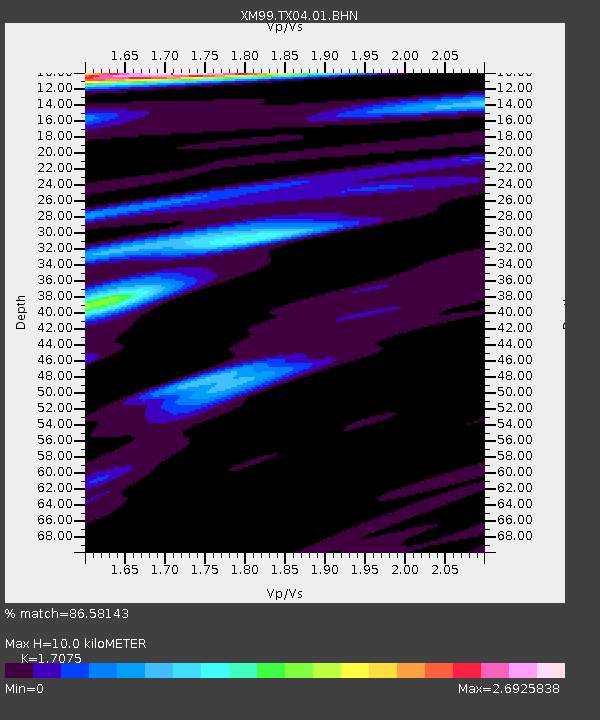
| Estimated Moho Depth: |
10.0 km |
| Estimated Crust Vp/Vs: |
1.71 |
| Assumed Crust Vp: |
6.121 km/s |
| Estimated Crust Vs: |
3.584 km/s |
| Estimated Crust Poisson's Ratio: |
0.24 |
|
| Radial Match: |
86.58143 % |
| Radial Bump: |
400 |
| Transverse Match: |
67.79004 % |
| Transverse Bump: |
400 |
| SOD ConfigId: |
27569 |
| Insert Time: |
2010-02-26 17:35:22.460 +0000 |
| GWidth: |
2.5 |
| Max Bumps: |
400 |
| Tol: |
0.001 |
|

Signal To Noise
| Channel | StoN | STA | LTA |
| XM:TX04:01:BHN:19991013T01:41:32.826014Z | 0.48256654 | 1.03222405E-7 | 2.1390296E-7 |
| XM:TX04:01:BHE:19991013T01:41:32.826014Z | 0.63444483 | 1.0584548E-7 | 1.6683165E-7 |
| XM:TX04:01:BHZ:19991013T01:41:32.826014Z | 1.0194088 | 2.624828E-7 | 2.5748534E-7 |
| Arrivals |
| Ps | 1.2 SECOND |
| PpPs | 4.2 SECOND |
| PsPs/PpSs | 5.4 SECOND |


