
Station XM TX04 - Texas04
Network: XM99 - Rio Grande Seismic Transect
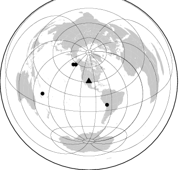
Nearby stations (2 deg radius)
| Station | Name | (Lat, Lon) | Start / End | Elevation |
| TX04 | Texas04 | (31.73, -103.45) | 1999-09-11 / 2001-12-31 | 833 m |
| Crust2 Type: | Q1,orogen/39km no ice, Appalachians, North Andes |
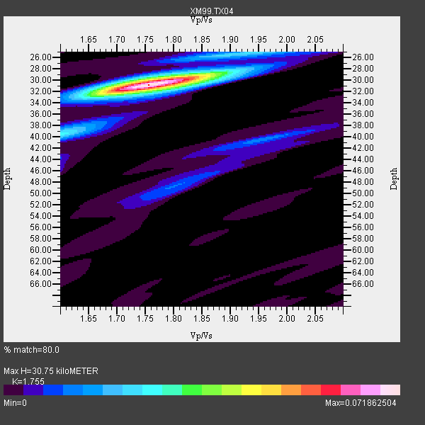
| Thickness Estimate: | 31 km |
| Thickness StdDev: | 1.7 km |
| Vp/Vs Estimate: | 1.75 |
| Vp/Vs StdDev: | 0.04 |
| Vs Estimate: | 3.487 km/s |
| Poisson's Ratio: | 0.26 |
| Peak Value: | 0.07 |
| Assumed Vp: | 6.121 km/s |
| Ps Weight: | 0.33333334 |
| PpPs Weight: | 0.33333334 |
| PsPs Weight: | 0.33333328 |
| Residual Complexity: | 0.315 |
| Nearby stations H: | +- |
| (2.0 deg) Vp/Vs: | +- |
2 with match > 90% ( 40.0 %) and 4 with match > 80% ( 80.0 %) out of 5.
Download stack as xyz text file.
Azimuth Distribution of Events:
Prior Results for this Station
| Study | Thickness | Vp/Vs | Vp | Vs | Poissons Ratio | Extra |
| EARS | 31 km | 1.75 | 6.121 km/s | 3.487 km/s | 0.26 | |
| Crust2.0 | 39 km | 1.76 | 6.121 km/s | 3.485 km/s | 0.26 | Q1,orogen/39km no ice, Appalachians, North Andes |
| Wilson | 45 km | 1.75 | 6.29 km/s | 3.594 km/s | 0.26 | |
| Global Maxima | 31 km | 1.75 | 6.121 km/s | 3.487 km/s | 0.26 | amp=0.071862504 |
| Local Maxima 1 | 40 km | 1.60 | 6.121 km/s | 3.825 km/s | 0.18 | amp=0.024907771 |
| Local Maxima 2 | 30 km | 1.76 | 6.121 km/s | 3.483 km/s | 0.26 | amp=0.018568704 |
| Local Maxima 3 | 31 km | 1.81 | 6.121 km/s | 3.386 km/s | 0.28 | amp=0.012325709 |
| Local Maxima 4 | 40 km | 1.96 | 6.121 km/s | 3.127 km/s | 0.32 | amp=0.011913189 |
| Predicted Arrivals for vertical incidence (zero ray parameter) | |
| Ps | 3.79 SECOND |
| PpPs | 13.84 SECOND |
| PsPs/PpSs | 17.63 SECOND |
Events Processed for this Station
Download zip of receiver functions as SAC
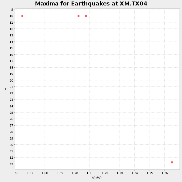
Plot maxima for each earthquake.
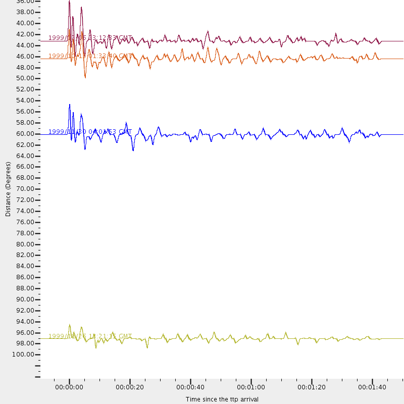
Events Used in the Stack
(4 events)| Radial Match | Distance | Baz | FERegion | Time | Lat/Lon | Depth | Magnitude |
| 95.68053 | 97.1 deg | 255.172 deg | Vanuatu Islands | 1999/11/26 13:21:15 GMT | (-16.4, 168.2) | 33 km | 6.4 MB, 7.3 MS, 7.5 MW, 7.3 MW |
| 95.04836 | 43.1 deg | 321.991 deg | Kodiak Island Region, Alaska | 1999/12/06 23:12:33 GMT | (57.4, -154.5) | 66 km | 6.8 MB, 7.0 MW, 7.0 ML |
| 89.647484 | 60.1 deg | 142.058 deg | Northern Chile | 1999/11/30 04:01:53 GMT | (-18.9, -69.2) | 128 km | 6.2 MB, 6.6 MW, 6.5 MW |
| 86.58143 | 46.4 deg | 317.228 deg | Alaska Peninsula | 1999/10/13 01:33:40 GMT | (54.7, -161.2) | 30 km | 6.0 MB, 6.2 MS, 6.5 MW, 6.0 ML |
Losers
(1 events)| Radial Match | Distance | Baz | FERegion | Time | Lat/Lon | Depth | Magnitude | Reason |
| 81.36553 | 83.3 deg | 245.116 deg | Tonga Islands | 2000/01/26 13:26:50 GMT | (-17.3, -174.0) | 33 km | 5.9 MB, 6.0 MS, 6.4 MW, 6.3 MW |
