You are here: Home > Network List > XM99 - Rio Grande Seismic Transect Stations List
> Station TX04 Texas04 > Earthquake Result Viewer
TX04 Texas04 - Earthquake Result Viewer
| Earthquake location: |
Kodiak Island Region, Alaska |
| Earthquake latitude/longitude: |
57.4/-154.5 |
| Earthquake time(UTC): |
1999/12/06 (340) 23:12:33 GMT |
| Earthquake Depth: |
66 km |
| Earthquake Magnitude: |
6.8 MB, 7.0 MW, 7.0 ML |
| Earthquake Catalog/Contributor: |
WHDF/NEIC |
|
| Network: |
XM Rio Grande Seismic Transect |
| Station: |
TX04 Texas04 |
| Lat/Lon: |
31.73 N/103.45 W |
| Elevation: |
833 m |
|
| Distance: |
43.1 deg |
| Az: |
104.167 deg |
| Baz: |
321.991 deg |
| Ray Param: |
0.07255941 |
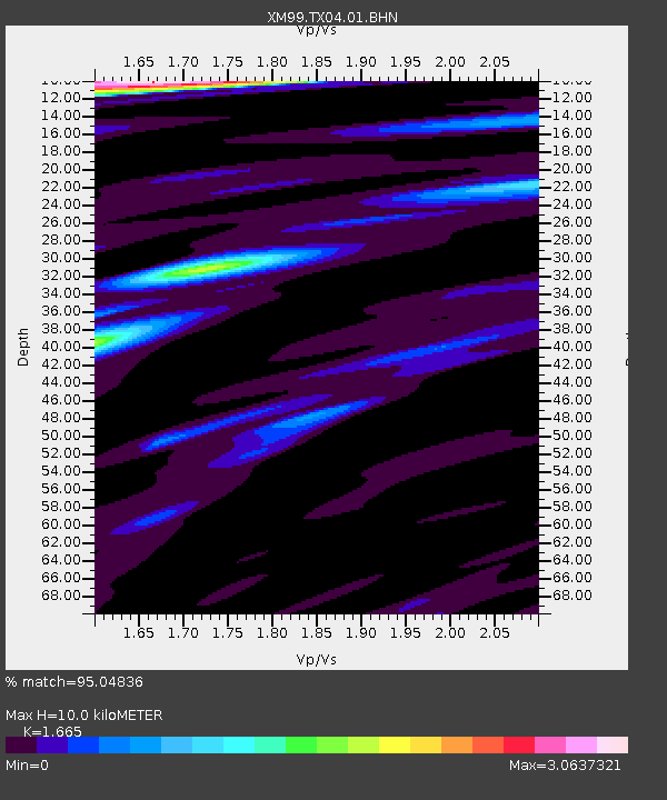
| Estimated Moho Depth: |
10.0 km |
| Estimated Crust Vp/Vs: |
1.66 |
| Assumed Crust Vp: |
6.121 km/s |
| Estimated Crust Vs: |
3.676 km/s |
| Estimated Crust Poisson's Ratio: |
0.22 |
|
| Radial Match: |
95.04836 % |
| Radial Bump: |
400 |
| Transverse Match: |
86.70139 % |
| Transverse Bump: |
400 |
| SOD ConfigId: |
27569 |
| Insert Time: |
2010-02-26 17:35:24.864 +0000 |
| GWidth: |
2.5 |
| Max Bumps: |
400 |
| Tol: |
0.001 |
|

Signal To Noise
| Channel | StoN | STA | LTA |
| XM:TX04:01:BHN:19991206T23:19:57.222002Z | 5.99404 | 1.0417749E-6 | 1.738018E-7 |
| XM:TX04:01:BHE:19991206T23:19:57.222002Z | 3.7349477 | 9.208035E-7 | 2.4653718E-7 |
| XM:TX04:01:BHZ:19991206T23:19:57.222002Z | 10.052988 | 3.0984631E-6 | 3.0821317E-7 |
| Arrivals |
| Ps | 1.2 SECOND |
| PpPs | 4.1 SECOND |
| PsPs/PpSs | 5.2 SECOND |


