You are here: Home > Network List > XK99 - CDROM (Colorado) Stations List
> Station S05 South 05 > Earthquake Result Viewer
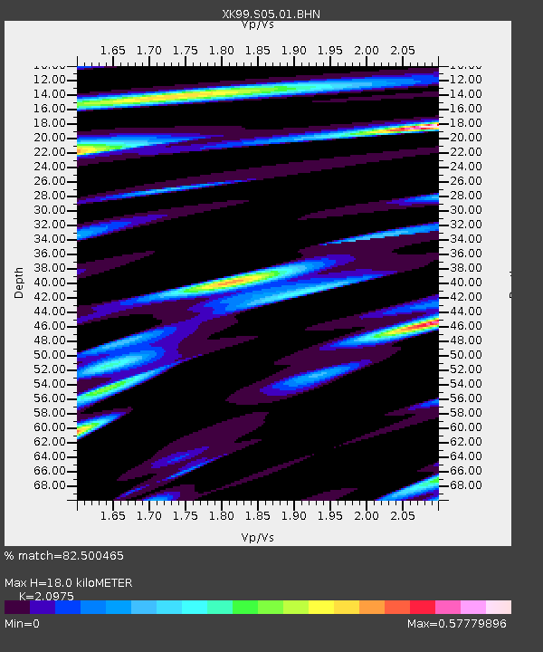
S05 South 05 - Earthquake Result Viewer
| Earthquake location: |
Kenai Peninsula, Alaska |
| Earthquake latitude/longitude: |
59.3/-151.5 |
| Earthquake time(UTC): |
1999/05/05 (125) 10:30:03 GMT |
| Earthquake Depth: |
71 km |
| Earthquake Magnitude: |
5.4 MB, 5.8 MW, 5.8 MW |
| Earthquake Catalog/Contributor: |
WHDF/NEIC |
|
| Network: |
XK CDROM (Colorado) |
| Station: |
S05 South 05 |
| Lat/Lon: |
36.88 N/105.40 W |
| Elevation: |
2566 m |
|
| Distance: |
37.1 deg |
| Az: |
106.42 deg |
| Baz: |
322.125 deg |
| Ray Param: |
0.076139115 |
| Estimated Moho Depth: |
18.0 km |
| Estimated Crust Vp/Vs: |
2.10 |
| Assumed Crust Vp: |
6.316 km/s |
| Estimated Crust Vs: |
3.011 km/s |
| Estimated Crust Poisson's Ratio: |
0.35 |
|
| Radial Match: |
82.500465 % |
| Radial Bump: |
400 |
| Transverse Match: |
66.13454 % |
| Transverse Bump: |
400 |
| SOD ConfigId: |
287362 |
| Insert Time: |
2010-03-09 22:45:42.723 +0000 |
| GWidth: |
2.5 |
| Max Bumps: |
400 |
| Tol: |
0.001 |
|

Signal To Noise
| Channel | StoN | STA | LTA |
| XK:S05:01:BHN:19990505T10:36:35.882013Z | 3.704987 | 3.0248276E-7 | 8.164206E-8 |
| XK:S05:01:BHE:19990505T10:36:35.882013Z | 3.477526 | 3.1269795E-7 | 8.991966E-8 |
| XK:S05:01:BHZ:19990505T10:36:35.882013Z | 9.609153 | 7.617561E-7 | 7.927401E-8 |
| Arrivals |
| Ps | 3.3 SECOND |
| PpPs | 8.3 SECOND |
| PsPs/PpSs | 12 SECOND |


