
Station XK S05 - South 05
Network: XK99 - CDROM (Colorado)
Nearby stations (2 deg radius)
| Station | Name | (Lat, Lon) | Start / End | Elevation |
| S05 | South 05 | (36.88, -105.40) | 1999-04-23 / 2000-12-31 | 2.6 km |
| Crust2 Type: | PC,orogen/45km, Orogen, 1 km seds. |
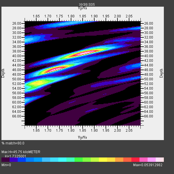
| Thickness Estimate: | 46 km |
| Thickness StdDev: | 3.9 km |
| Vp/Vs Estimate: | 1.73 |
| Vp/Vs StdDev: | 0.07 |
| Vs Estimate: | 3.645 km/s |
| Poisson's Ratio: | 0.25 |
| Peak Value: | 0.05 |
| Assumed Vp: | 6.316 km/s |
| Ps Weight: | 0.33333334 |
| PpPs Weight: | 0.33333334 |
| PsPs Weight: | 0.33333328 |
| Residual Complexity: | 0.659 |
| Nearby stations H: | +- |
| (2.0 deg) Vp/Vs: | +- |
2 with match > 90% ( 33.333332 %) and 6 with match > 80% ( 100.0 %) out of 6.
Download stack as xyz text file.
Azimuth Distribution of Events:

Prior Results for this Station
| Study | Thickness | Vp/Vs | Vp | Vs | Poissons Ratio | Extra |
| EARS | 46 km | 1.73 | 6.316 km/s | 3.645 km/s | 0.25 | |
| Crust2.0 | 45 km | 1.76 | 6.316 km/s | 3.587 km/s | 0.26 | PC,orogen/45km, Orogen, 1 km seds. |
| Global Maxima | 46 km | 1.73 | 6.316 km/s | 3.645 km/s | 0.25 | amp=0.053912982 |
| Local Maxima 1 | 38 km | 1.87 | 6.316 km/s | 3.382 km/s | 0.30 | amp=0.044616044 |
| Local Maxima 2 | 52 km | 1.64 | 6.316 km/s | 3.857 km/s | 0.20 | amp=0.025320169 |
| Local Maxima 3 | 33 km | 1.60 | 6.316 km/s | 3.947 km/s | 0.18 | amp=0.020171024 |
| Local Maxima 4 | 52 km | 1.69 | 6.316 km/s | 3.731 km/s | 0.23 | amp=0.017347146 |
| Predicted Arrivals for vertical incidence (zero ray parameter) | |
| Ps | 5.31 SECOND |
| PpPs | 19.79 SECOND |
| PsPs/PpSs | 25.10 SECOND |
Events Processed for this Station
Download zip of receiver functions as SAC
Plot maxima for each earthquake.
Events Used in the Stack
(6 events)| Radial Match | Distance | Baz | FERegion | Time | Lat/Lon | Depth | Magnitude |
| 94.12144 | 37.1 deg | 317.18 deg | Kodiak Island Region, Alaska | 1999/05/07 14:13:52 GMT | (56.4, -152.9) | 20 km | 5.7 MB, 6.1 MS, 6.4 MW, 5.7 ME |
| 92.97125 | 94.0 deg | 237.042 deg | Kermadec Islands Region | 1999/07/19 02:17:03 GMT | (-28.6, -177.6) | 39 km | 6.3 MB, 6.2 MS, 6.4 MW, 6.3 ME |
| 86.401924 | 68.4 deg | 315.861 deg | Kuril Islands | 1999/07/07 18:52:57 GMT | (49.2, 155.6) | 33 km | 6.0 MB, 5.6 MS, 6.1 MW, 5.8 ME |
| 84.415184 | 78.6 deg | 315.617 deg | Hokkaido, Japan Region | 1999/05/12 17:59:22 GMT | (43.0, 143.8) | 103 km | 5.9 MB, 6.2 MW, 6.1 MW |
| 82.58808 | 72.7 deg | 314.065 deg | Kuril Islands | 1999/05/08 19:44:35 GMT | (45.4, 151.6) | 63 km | 6.2 MB, 5.3 MS, 5.9 MW, 5.9 MW |
| 82.500465 | 37.1 deg | 322.125 deg | Kenai Peninsula, Alaska | 1999/05/05 10:30:03 GMT | (59.3, -151.5) | 71 km | 5.4 MB, 5.8 MW, 5.8 MW |
Losers
(0 events)| Radial Match | Distance | Baz | FERegion | Time | Lat/Lon | Depth | Magnitude | Reason |
