You are here: Home > Network List > XK99 - CDROM (Colorado) Stations List
> Station S11 South 11 > Earthquake Result Viewer
S11 South 11 - Earthquake Result Viewer
| Earthquake location: |
Tonga Islands |
| Earthquake latitude/longitude: |
-15.9/-174.0 |
| Earthquake time(UTC): |
1999/12/07 (341) 21:29:49 GMT |
| Earthquake Depth: |
138 km |
| Earthquake Magnitude: |
6.2 MB, 6.4 MW, 6.4 MW |
| Earthquake Catalog/Contributor: |
WHDF/NEIC |
|
| Network: |
XK CDROM (Colorado) |
| Station: |
S11 South 11 |
| Lat/Lon: |
36.34 N/105.28 W |
| Elevation: |
2663 m |
|
| Distance: |
83.0 deg |
| Az: |
49.278 deg |
| Baz: |
244.574 deg |
| Ray Param: |
0.04616295 |
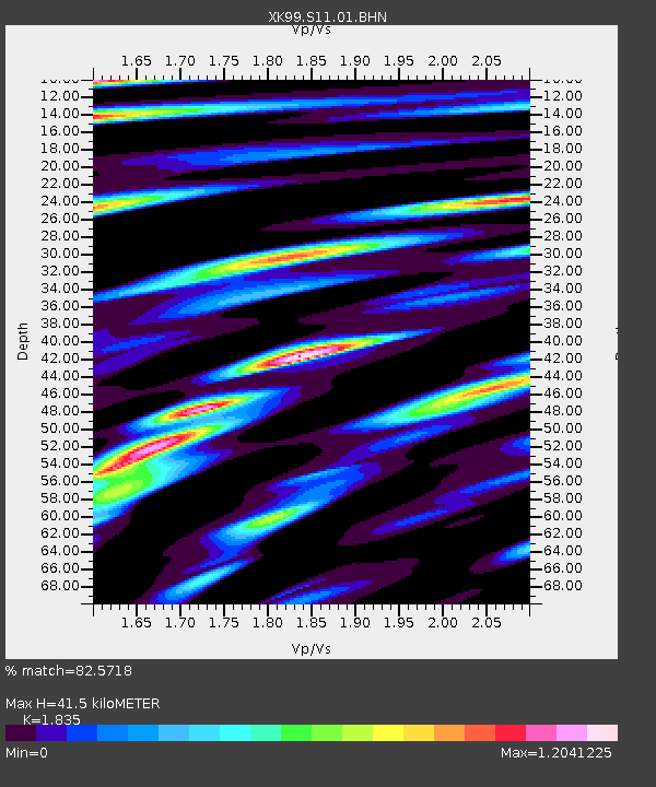
| Estimated Moho Depth: |
41.5 km |
| Estimated Crust Vp/Vs: |
1.84 |
| Assumed Crust Vp: |
6.316 km/s |
| Estimated Crust Vs: |
3.442 km/s |
| Estimated Crust Poisson's Ratio: |
0.29 |
|
| Radial Match: |
82.5718 % |
| Radial Bump: |
400 |
| Transverse Match: |
78.07859 % |
| Transverse Bump: |
400 |
| SOD ConfigId: |
287362 |
| Insert Time: |
2010-03-09 22:48:07.772 +0000 |
| GWidth: |
2.5 |
| Max Bumps: |
400 |
| Tol: |
0.001 |
|

Signal To Noise
| Channel | StoN | STA | LTA |
| XK:S11:01:BHN:19991207T21:41:28.142009Z | 2.3684099 | 3.0570922E-7 | 1.2907783E-7 |
| XK:S11:01:BHE:19991207T21:41:28.142009Z | 2.2813802 | 4.7113275E-7 | 2.0651217E-7 |
| XK:S11:01:BHZ:19991207T21:41:28.142009Z | 7.1685705 | 1.4619574E-6 | 2.0393988E-7 |
| Arrivals |
| Ps | 5.6 SECOND |
| PpPs | 18 SECOND |
| PsPs/PpSs | 24 SECOND |


