
Station XK S11 - South 11
Network: XK99 - CDROM (Colorado)
Nearby stations (2 deg radius)
| Station | Name | (Lat, Lon) | Start / End | Elevation |
| S11 | South 11 | (36.34, -105.28) | 1999-04-20 / 2000-12-31 | 2663 m |
| Crust2 Type: | PC,orogen/45km, Orogen, 1 km seds. |
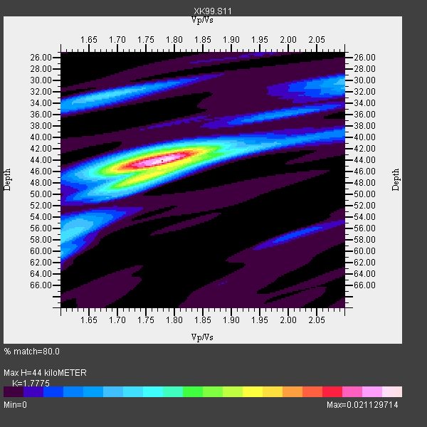
| Thickness Estimate: | 44 km |
| Thickness StdDev: | 2.4 km |
| Vp/Vs Estimate: | 1.78 |
| Vp/Vs StdDev: | 0.05 |
| Vs Estimate: | 3.553 km/s |
| Poisson's Ratio: | 0.27 |
| Peak Value: | 0.02 |
| Assumed Vp: | 6.316 km/s |
| Ps Weight: | 0.33333334 |
| PpPs Weight: | 0.33333334 |
| PsPs Weight: | 0.33333328 |
| Residual Complexity: | 0.523 |
| Nearby stations H: | +- |
| (2.0 deg) Vp/Vs: | +- |
4 with match > 90% ( 26.666666 %) and 15 with match > 80% ( 100.0 %) out of 15.
Download stack as xyz text file.
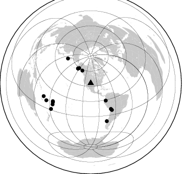
Azimuth Distribution of Events:
Prior Results for this Station
| Study | Thickness | Vp/Vs | Vp | Vs | Poissons Ratio | Extra |
| EARS | 44 km | 1.78 | 6.316 km/s | 3.553 km/s | 0.27 | |
| Crust2.0 | 45 km | 1.76 | 6.316 km/s | 3.587 km/s | 0.26 | PC,orogen/45km, Orogen, 1 km seds. |
| Global Maxima | 44 km | 1.78 | 6.316 km/s | 3.553 km/s | 0.27 | amp=0.021129714 |
| Local Maxima 1 | 46 km | 1.77 | 6.316 km/s | 3.563 km/s | 0.27 | amp=0.009292971 |
| Local Maxima 2 | 44 km | 1.75 | 6.316 km/s | 3.614 km/s | 0.26 | amp=0.00848904 |
| Local Maxima 3 | 32 km | 1.68 | 6.316 km/s | 3.754 km/s | 0.23 | amp=0.007404382 |
| Local Maxima 4 | 58 km | 1.60 | 6.316 km/s | 3.947 km/s | 0.18 | amp=0.0056124954 |
| Predicted Arrivals for vertical incidence (zero ray parameter) | |
| Ps | 5.42 SECOND |
| PpPs | 19.35 SECOND |
| PsPs/PpSs | 24.77 SECOND |
Events Processed for this Station
Download zip of receiver functions as SAC
Plot maxima for each earthquake.
Events Used in the Stack
(15 events)| Radial Match | Distance | Baz | FERegion | Time | Lat/Lon | Depth | Magnitude |
| 94.833145 | 38.6 deg | 318.946 deg | Kodiak Island Region, Alaska | 1999/12/06 23:12:33 GMT | (57.4, -154.5) | 66 km | 6.8 MB, 7.0 MW, 7.0 ML |
| 93.41404 | 81.5 deg | 156.945 deg | Off Coast Of Southern Chile | 1999/08/22 09:35:39 GMT | (-40.5, -74.8) | 33 km | 6.2 MB, 5.8 MS, 6.4 MW, 6.2 MW |
| 93.18129 | 96.8 deg | 254.737 deg | Vanuatu Islands | 1999/11/26 13:21:15 GMT | (-16.4, 168.2) | 33 km | 6.4 MB, 7.3 MS, 7.5 MW, 7.3 MW |
| 92.52155 | 94.3 deg | 249.065 deg | Vanuatu Islands Region | 2000/02/25 01:43:58 GMT | (-19.5, 173.8) | 33 km | 6.1 MB, 7.1 MS, 7.1 MW, 7.0 MW |
| 87.4382 | 66.7 deg | 317.196 deg | Near East Coast Of Kamchatka | 1999/09/18 21:28:33 GMT | (51.2, 157.6) | 60 km | 5.9 MB, 5.6 MS, 6.2 MW, 6.0 MW |
| 86.847786 | 83.9 deg | 243.554 deg | Tonga Islands | 2000/01/26 13:26:50 GMT | (-17.3, -174.0) | 33 km | 5.9 MB, 6.0 MS, 6.4 MW, 6.3 MW |
| 86.39027 | 93.8 deg | 237.078 deg | Kermadec Islands Region | 1999/07/19 02:17:03 GMT | (-28.6, -177.6) | 39 km | 6.3 MB, 6.2 MS, 6.4 MW, 6.3 ME |
| 85.645164 | 38.6 deg | 318.861 deg | Kodiak Island Region, Alaska | 1999/12/07 00:19:49 GMT | (57.4, -154.5) | 41 km | 6.5 MB, 6.1 MS, 6.4 MW, 6.3 ML |
| 84.99151 | 67.3 deg | 141.412 deg | Southern Bolivia | 1999/09/15 03:01:24 GMT | (-20.9, -67.3) | 218 km | 6.0 MB, 6.4 MW, 6.4 MW |
| 82.85593 | 86.4 deg | 241.06 deg | Tonga Islands | 2000/01/02 15:16:32 GMT | (-20.8, -174.2) | 33 km | 5.5 MB, 5.8 MS, 5.8 MW, 5.8 MW |
| 82.751724 | 37.5 deg | 322.528 deg | Kenai Peninsula, Alaska | 1999/05/05 10:30:03 GMT | (59.3, -151.5) | 71 km | 5.4 MB, 5.8 MW, 5.8 MW |
| 82.5718 | 83.0 deg | 244.574 deg | Tonga Islands | 1999/12/07 21:29:49 GMT | (-15.9, -174.0) | 138 km | 6.2 MB, 6.4 MW, 6.4 MW |
| 82.32771 | 30.1 deg | 326.216 deg | Southeastern Alaska | 2000/01/06 10:42:25 GMT | (58.0, -136.9) | 1.0 km | 5.5 MB, 5.9 MS, 6.1 MW, 6.1 ML |
| 82.22465 | 64.7 deg | 141.886 deg | Northern Chile | 1999/11/30 04:01:53 GMT | (-18.9, -69.2) | 128 km | 6.2 MB, 6.6 MW, 6.5 MW |
| 80.71413 | 45.5 deg | 139.258 deg | Ecuador | 1999/08/28 12:40:06 GMT | (-1.3, -77.5) | 196 km | 5.9 MB, 6.3 MW, 6.2 MW |
Losers
(0 events)| Radial Match | Distance | Baz | FERegion | Time | Lat/Lon | Depth | Magnitude | Reason |
