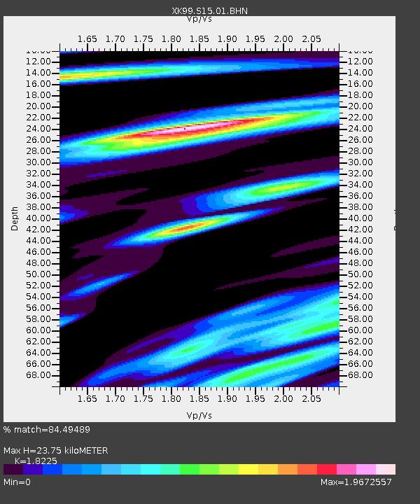
S15 South 15 - Earthquake Result Viewer

Earthquake location: Andreanof Islands, Aleutian Is.
Earthquake latitude/longitude: 51.4/-178.1
Earthquake time(UTC): 2000/04/21 (112) 04:35:17 GMT
Earthquake Depth: 33 km
Earthquake Magnitude: 6.0 MB, 5.7 MS, 6.2 ML, 6.0 MW
Earthquake Catalog/Contributor: WHDF/NEIC
Network: XK CDROM (Colorado)
Station: S15 South 15
Lat/Lon: 35.97 N/105.22 W
Elevation: 2152 m
Distance: 52.8 deg
Az: 76.907 deg
Baz: 311.254 deg
Ray Param: 0.06649111
Estimated Moho Depth: 23.75 km
Estimated Crust Vp/Vs: 1.82
Assumed Crust Vp: 6.419 km/s
Estimated Crust Vs: 3.522 km/s
Estimated Crust Poisson's Ratio: 0.28
Radial Match: 84.49489 %
Radial Bump: 400
Transverse Match: 74.67076 %
Transverse Bump: 400
SOD ConfigId: 287362
Insert Time: 2010-03-09 22:49:45.327 +0000
GWidth: 2.5
Max Bumps: 400
Tol: 0.001

Signal To Noise

ChannelStoNSTALTA
XK:S15:01:BHN:20000421T04:43:58.827024Z2.2722682.669353E-71.1747526E-7
XK:S15:01:BHE:20000421T04:43:58.827024Z2.04787923.2271612E-71.5758552E-7
XK:S15:01:BHZ:20000421T04:43:58.827024Z5.514736.372722E-71.1555818E-7
Arrivals
Ps3.2 SECOND
PpPs9.9 SECOND
PsPs/PpSs13 SECOND