
Station XK S15 - South 15
Network: XK99 - CDROM (Colorado)
Nearby stations (2 deg radius)

| Station | Name | (Lat, Lon) | Start / End | Elevation |
| S15 | South 15 | (35.97, -105.22) | 1999-04-18 / 2000-12-31 | 2152 m |
| Crust2 Type: | Q2,orogen/39km no ice, Appalachians, North Andes, 0.5 km seds. |
| Thickness Estimate: | 32 km |
| Thickness StdDev: | 6.4 km |
| Vp/Vs Estimate: | 2.09 |
| Vp/Vs StdDev: | 0.15 |
| Vs Estimate: | 3.079 km/s |
| Poisson's Ratio: | 0.35 |
| Peak Value: | 0.03 |
| Assumed Vp: | 6.419 km/s |
| Ps Weight: | 0.33333334 |
| PpPs Weight: | 0.33333334 |
| PsPs Weight: | 0.33333328 |
| Residual Complexity: | 0.748 |
| Nearby stations H: | +- |
| (2.0 deg) Vp/Vs: | +- |
3 with match > 90% ( 50.0 %) and 6 with match > 80% ( 100.0 %) out of 6.
Download stack as xyz text file.
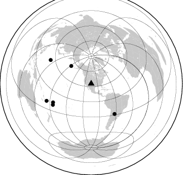
Azimuth Distribution of Events:
Prior Results for this Station
| Study | Thickness | Vp/Vs | Vp | Vs | Poissons Ratio | Extra |
| EARS | 32 km | 2.09 | 6.419 km/s | 3.079 km/s | 0.35 | |
| Crust2.0 | 39 km | 1.75 | 6.419 km/s | 3.659 km/s | 0.26 | Q2,orogen/39km no ice, Appalachians, North Andes, 0.5 km seds. |
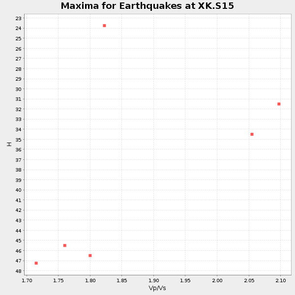
| Global Maxima | 32 km | 2.09 | 6.419 km/s | 3.079 km/s | 0.35 | amp=0.028907992 |
| Local Maxima 1 | 43 km | 1.79 | 6.419 km/s | 3.581 km/s | 0.27 | amp=0.019835183 |
| Local Maxima 2 | 33 km | 2.07 | 6.419 km/s | 3.109 km/s | 0.35 | amp=0.013705403 |
| Local Maxima 3 | 47 km | 1.73 | 6.419 km/s | 3.721 km/s | 0.25 | amp=0.012436563 |
| Local Maxima 4 | 58 km | 1.63 | 6.419 km/s | 3.938 km/s | 0.20 | amp=0.01044633 |
| Predicted Arrivals for vertical incidence (zero ray parameter) | |
| Ps | 5.32 SECOND |
| PpPs | 15.14 SECOND |
| PsPs/PpSs | 20.46 SECOND |
Events Processed for this Station
Download zip of receiver functions as SAC
Plot maxima for each earthquake.
Events Used in the Stack
(6 events)| Radial Match | Distance | Baz | FERegion | Time | Lat/Lon | Depth | Magnitude |
| 96.82026 | 92.8 deg | 300.106 deg | Volcano Islands, Japan Region | 2000/03/28 11:00:22 GMT | (22.3, 143.7) | 126 km | 6.8 MB, 7.6 MS, 7.6 MW, 7.6 MW |
| 96.309555 | 83.8 deg | 244.046 deg | Tonga Islands | 2000/01/08 16:47:20 GMT | (-16.9, -174.2) | 183 km | 6.5 MB, 6.6 MS, 7.2 MW, 7.0 ME |
| 91.672356 | 94.3 deg | 249.074 deg | Vanuatu Islands Region | 2000/02/25 01:43:58 GMT | (-19.5, 173.8) | 33 km | 6.1 MB, 7.1 MS, 7.1 MW, 7.0 MW |
| 89.22118 | 75.3 deg | 142.216 deg | Santiago Del Estero Prov., Arg. | 2000/04/23 09:27:23 GMT | (-28.3, -63.0) | 608 km | 6.6 MB, 7.0 MW, 7.0 MW |
| 85.368576 | 86.2 deg | 241.119 deg | Tonga Islands | 2000/01/02 15:16:32 GMT | (-20.8, -174.2) | 33 km | 5.5 MB, 5.8 MS, 5.8 MW, 5.8 MW |
| 84.49489 | 52.8 deg | 311.254 deg | Andreanof Islands, Aleutian Is. | 2000/04/21 04:35:17 GMT | (51.4, -178.1) | 33 km | 6.0 MB, 5.7 MS, 6.2 ML, 6.0 MW |
Losers
(0 events)| Radial Match | Distance | Baz | FERegion | Time | Lat/Lon | Depth | Magnitude | Reason |
