You are here: Home > Network List > XK99 - CDROM (Colorado) Stations List
> Station S15 South 15 > Earthquake Result Viewer
S15 South 15 - Earthquake Result Viewer
| Earthquake location: |
Tonga Islands |
| Earthquake latitude/longitude: |
-20.8/-174.2 |
| Earthquake time(UTC): |
2000/01/02 (002) 15:16:32 GMT |
| Earthquake Depth: |
33 km |
| Earthquake Magnitude: |
5.5 MB, 5.8 MS, 5.8 MW, 5.8 MW |
| Earthquake Catalog/Contributor: |
WHDF/NEIC |
|
| Network: |
XK CDROM (Colorado) |
| Station: |
S15 South 15 |
| Lat/Lon: |
35.97 N/105.22 W |
| Elevation: |
2152 m |
|
| Distance: |
86.2 deg |
| Az: |
49.38 deg |
| Baz: |
241.119 deg |
| Ray Param: |
0.044154767 |
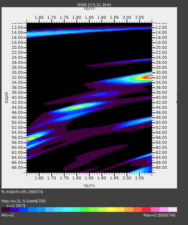
| Estimated Moho Depth: |
31.5 km |
| Estimated Crust Vp/Vs: |
2.10 |
| Assumed Crust Vp: |
6.419 km/s |
| Estimated Crust Vs: |
3.06 km/s |
| Estimated Crust Poisson's Ratio: |
0.35 |
|
| Radial Match: |
85.368576 % |
| Radial Bump: |
400 |
| Transverse Match: |
76.77019 % |
| Transverse Bump: |
378 |
| SOD ConfigId: |
16820 |
| Insert Time: |
2010-03-09 22:49:55.093 +0000 |
| GWidth: |
2.5 |
| Max Bumps: |
400 |
| Tol: |
0.001 |
|

Signal To Noise
| Channel | StoN | STA | LTA |
| XK:S15:01:BHN:20000102T15:28:39.261018Z | 1.7940282 | 3.2169274E-7 | 1.7931308E-7 |
| XK:S15:01:BHE:20000102T15:28:39.261018Z | 1.5255636 | 3.6937783E-7 | 2.4212548E-7 |
| XK:S15:01:BHZ:20000102T15:28:39.261018Z | 0.3168082 | 5.002745E-7 | 1.5791085E-6 |
| Arrivals |
| Ps | 5.5 SECOND |
| PpPs | 15 SECOND |
| PsPs/PpSs | 20 SECOND |


