You are here: Home > Network List > XK99 - CDROM (Colorado) Stations List
> Station S19 South 19 > Earthquake Result Viewer
S19 South 19 - Earthquake Result Viewer
| Earthquake location: |
Tonga Islands |
| Earthquake latitude/longitude: |
-20.8/-174.2 |
| Earthquake time(UTC): |
2000/01/02 (002) 15:16:32 GMT |
| Earthquake Depth: |
33 km |
| Earthquake Magnitude: |
5.5 MB, 5.8 MS, 5.8 MW, 5.8 MW |
| Earthquake Catalog/Contributor: |
WHDF/NEIC |
|
| Network: |
XK CDROM (Colorado) |
| Station: |
S19 South 19 |
| Lat/Lon: |
35.60 N/105.18 W |
| Elevation: |
1977 m |
|
| Distance: |
86.1 deg |
| Az: |
49.722 deg |
| Baz: |
241.163 deg |
| Ray Param: |
0.04426345 |
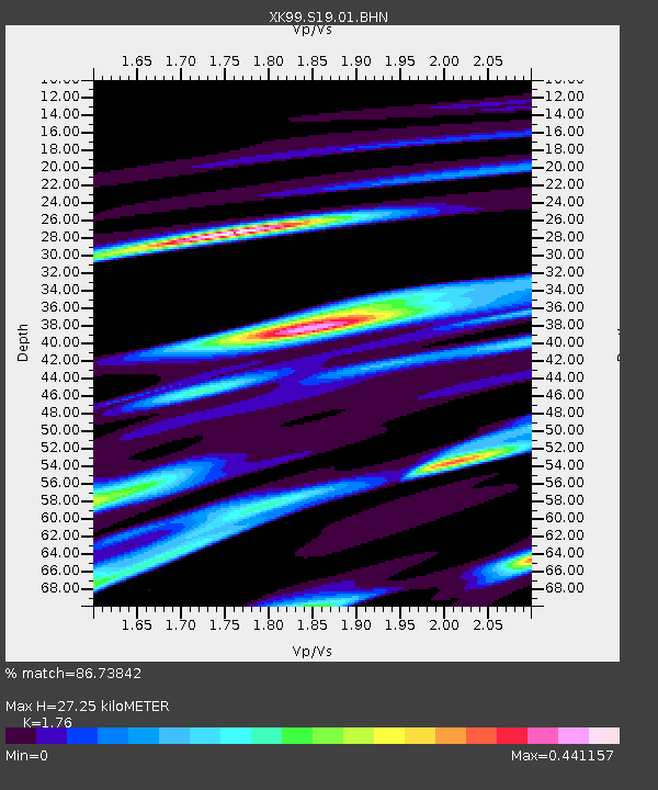
| Estimated Moho Depth: |
27.25 km |
| Estimated Crust Vp/Vs: |
1.76 |
| Assumed Crust Vp: |
6.419 km/s |
| Estimated Crust Vs: |
3.647 km/s |
| Estimated Crust Poisson's Ratio: |
0.26 |
|
| Radial Match: |
86.73842 % |
| Radial Bump: |
379 |
| Transverse Match: |
75.70466 % |
| Transverse Bump: |
400 |
| SOD ConfigId: |
287362 |
| Insert Time: |
2010-03-09 22:51:21.156 +0000 |
| GWidth: |
2.5 |
| Max Bumps: |
400 |
| Tol: |
0.001 |
|

Signal To Noise
| Channel | StoN | STA | LTA |
| XK:S19:01:BHN:20000102T15:28:38.555024Z | 0.4625602 | 4.6618567E-8 | 1.0078379E-7 |
| XK:S19:01:BHE:20000102T15:28:38.555024Z | 1.1840428 | 1.4932219E-7 | 1.2611216E-7 |
| XK:S19:01:BHZ:20000102T15:28:38.555024Z | 3.544819 | 2.3654992E-7 | 6.673117E-8 |
| Arrivals |
| Ps | 3.3 SECOND |
| PpPs | 11 SECOND |
| PsPs/PpSs | 15 SECOND |


